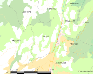
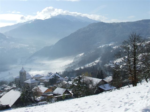
Césarches (Césarches)

- коммуна во Франции
 Hiking in Césarches
Césarches is a lesser-known area for hiking, but it can offer beautiful views and a peaceful experience in nature, particularly if you're looking for a more secluded adventure. While detailed information might be sparse, the region generally features scenic landscapes, including forests, valleys, and streams.
When planning a hike in Césarches, consider the following tips:
-
Trail Maps: Since Césarches isn't a well-documented hiking destination, it's essential to have a reliable trail map or a GPS device. Check local resources or hiking apps for any available routes.
-
Difficulty Levels: Assess your fitness levels and the difficulty of the trails you might find. It's advisable to start with easier hikes if you're unfamiliar with the area.
-
Weather Conditions: Before heading out, check the weather forecast. Mountain weather can change quickly, so be prepared for varying conditions.
-
Safety: Make sure to inform someone of your hiking plans, especially if you’re venturing into less-traveled areas. Always carry a first aid kit, plenty of water, and snacks.
-
Leave No Trace: Follow the principles of Leave No Trace to preserve the natural beauty of the area. Pack out any trash, stay on designated trails, and respect wildlife.
-
Local Regulations: Familiarize yourself with any local rules or regulations regarding hiking in Césarches, including permits if required.
While Césarches may not have the most extensive hiking resources, the tranquility and beauty of the surroundings can provide a wonderful outdoor experience. Enjoy your adventure!
- Страна:

- Почтовый код: 73200
- Координаты: 45° 42' 4" N, 6° 24' 43" E


- GPS треки (wikiloc): [Ссылка]
- Площадь: 2.9 кв.км
- Население: 425
- Википедия английская: wiki(en)
- Википедия национальная: wiki(fr)
- Хранилище Wikidata: Wikidata: Q568425
- Катеория в википедии: [Ссылка]
- код Freebase: [/m/03npgcl]
- код GeoNames: Альт: [6450989]
- номер SIREN: [217300615]
- код муниципалитета INSEE: 73061
Граничит с регионами:


Queige
- коммуна во Франции
Hiking in Queige
Queige is a picturesque village located in the French Alps, close to the Beaufortain massif. It offers beautiful landscapes, charming scenery, and a variety of hiking opportunities suitable for different skill levels....
- Страна:
- Почтовый код: 73720
- Координаты: 45° 43' 11" N, 6° 27' 33" E
- GPS треки (wikiloc): [Ссылка]
- Площадь: 32.61 кв.км
- Население: 825
- Веб сайт: [Ссылка]


Thénésol
- коммуна во Франции
Hiking in Thénésol
Thénésol is a picturesque village located in the French Alps, known for its stunning landscapes and proximity to a variety of hiking trails. Here are some highlights and tips for hiking in the Thénésol area:...
- Страна:
- Почтовый код: 73200
- Координаты: 45° 42' 44" N, 6° 23' 49" E
- GPS треки (wikiloc): [Ссылка]
- Площадь: 5.49 кв.км
- Население: 293
Вантон
- коммуна во Франции
Hiking in Вантон
Venthon is a beautiful destination for hiking enthusiasts, located in the Savoie region of the French Alps. The area offers a variety of hiking trails that cater to different skill levels, ranging from gentle walks to more challenging hikes....
- Страна:
- Почтовый код: 73200
- Координаты: 45° 41' 16" N, 6° 24' 49" E
- GPS треки (wikiloc): [Ссылка]
- Площадь: 2.5 кв.км
- Население: 635

Паллю
- коммуна во Франции
Hiking in Паллю
It seems like you might be referring to a specific location that might not be widely recognized or documented in hiking resources. If "Pallud" is a less-known area, it could also be a local or regional term....
- Страна:
- Почтовый код: 73200
- Координаты: 45° 41' 12" N, 6° 23' 40" E
- GPS треки (wikiloc): [Ссылка]
- Площадь: 5.2 кв.км
- Население: 756

Marthod
- коммуна во Франции
Hiking in Marthod
Marthod is a charming village located in the Savoie region of France, nestled in the Alps. It is a great base for hiking enthusiasts looking to explore the stunning mountainous terrain and enjoy breathtaking views of the surrounding landscapes. Here are some key points to consider when hiking in Marthod:...
- Страна:
- Почтовый код: 73400
- Координаты: 45° 43' 33" N, 6° 24' 13" E
- GPS треки (wikiloc): [Ссылка]
- Площадь: 14.78 кв.км
- Население: 1382