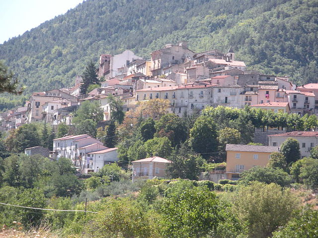
Кансано (Cansano, Cansano)
.svg)
- коммуна Италии
 Hiking in Кансано
Cansano is a quaint village situated in the Abruzzo region of Italy, known for its picturesque landscapes and access to a variety of hiking trails. The area is characterized by rolling hills, lush forests, and stunning mountain views, making it a fantastic destination for outdoor enthusiasts.
Popular Hiking Trails in Cansano:
-
Path of the Ancient Traces: This trail takes you through historical sites and offers insights into the local culture and history. The route is marked by scenic views and provides a gentle hike suitable for families.
-
The Val Reverperosa Loop: A moderately challenging hike that offers breathtaking views of the surrounding mountains. This trail is perfect for those looking to connect with nature and enjoy a quiet day away from the hustle and bustle.
-
Cansano to Lago di Scanno: A more challenging route leading to the beautiful Scanno Lake. This hike features a combination of steep ascents and descents, rewarding hikers with stunning lake views and natural surroundings.
Tips for Hiking in Cansano:
- Local Weather: Always check the weather conditions before heading out, as the weather can change rapidly in mountainous areas.
- Prepare Adequately: Ensure to bring sufficient water, snacks, and possibly a picnic to eat at scenic viewpoints.
- Footwear: Wear sturdy, comfortable hiking boots to navigate the terrain safely.
- Respect Nature: Follow Leave No Trace principles to preserve the beauty of the area for future hikers.
- Wildlife: Keep an eye out for local wildlife, but remember to maintain a safe distance.
Getting There:
Cansano is accessible by car, and there are public transport options from larger towns nearby. The best time to hike in the area is during spring and fall when temperatures are mild.
Whether you're a seasoned hiker or a beginner, Cansano offers diverse trails that highlight the natural beauty of the Abruzzo region, making it an excellent destination for all hiking enthusiasts. Enjoy your hiking adventure!
- Страна:

- Почтовый код: 67030
- Телефонный код: 0864
- Код автомобильного номера: AQ
- Координаты: 42° 0' 19" N, 14° 0' 46" E


- GPS треки (wikiloc): [Ссылка]
- Высота над уровнем моря: 835 м m
- Площадь: 37.7 кв.км
- Население: 244
- Веб сайт: https://www.bracontece.com.br/cansancao/
- Википедия русская: wiki(ru)
- Википедия английская: wiki(en)
- Википедия национальная: wiki(it)
- Хранилище Wikidata: Wikidata: Q50062
- Катеория в википедии: [Ссылка]
- код Freebase: [/m/0fg4fn]
- код GeoNames: Альт: [6541200]
- код VIAF: Альт: [237473956]
- ID отношения в OpenStreetMap: [41665]
- Google Maps Customer ID: [12319510293705373757]
- код ISTAT: 066018
- кадастровый код Италии: B624
Граничит с регионами:


Кампо-ди-Джове
- коммуна Италии
Hiking in Кампо-ди-Джове
Campo di Giove is a beautiful destination located in the Abruzzo region of Italy, nestled in the Apennine Mountains. This area is known for its natural beauty, rich history, and a variety of hiking trails that cater to different skill levels. Here are some key points about hiking in Campo di Giove:...
- Страна:
- Почтовый код: 67030
- Телефонный код: 0864
- Код автомобильного номера: AQ
- Координаты: 42° 0' 40" N, 14° 2' 25" E
- GPS треки (wikiloc): [Ссылка]
- Высота над уровнем моря: 1064 м m
- Площадь: 28.9 кв.км
- Население: 795
- Веб сайт: [Ссылка]

Пачентро
- коммуна Италии
Hiking in Пачентро
Pacentro, located in the Abruzzo region of Italy, is a charming hilltop village known for its stunning views, ancient architecture, and access to beautiful natural landscapes. Hiking in and around Pacentro offers a unique experience, blending culture, history, and nature....
- Страна:
- Почтовый код: 67030
- Телефонный код: 0864
- Код автомобильного номера: AQ
- Координаты: 42° 3' 2" N, 13° 59' 29" E
- GPS треки (wikiloc): [Ссылка]
- Высота над уровнем моря: 653 м m
- Площадь: 72.59 кв.км
- Население: 1140
- Веб сайт: [Ссылка]


Пескокостанцо
- коммуна Италии
Hiking in Пескокостанцо
Pescocostanzo is a charming village located in the Abruzzo region of Italy, nestled in the Apennine Mountains. It is a fantastic destination for hikers, offering a mix of stunning landscapes, historical sites, and a range of trails suitable for different skill levels....
- Страна:
- Почтовый код: 67033
- Телефонный код: 0864
- Код автомобильного номера: AQ
- Координаты: 41° 53' 14" N, 14° 3' 59" E
- GPS треки (wikiloc): [Ссылка]
- Высота над уровнем моря: 1395 м m
- Площадь: 55.06 кв.км
- Население: 1090
- Веб сайт: [Ссылка]

Петторано-суль-Джицио
- коммуна Италии
Hiking in Петторано-суль-Джицио
Pettorano sul Gizio is a charming village located in the province of L'Aquila in the Abruzzo region of Italy. Surrounded by the beautiful Apennine mountains, it offers numerous hiking opportunities, showcasing stunning landscapes, rich biodiversity, and fascinating historical sites....
- Страна:
- Почтовый код: 67034
- Телефонный код: 0864
- Код автомобильного номера: AQ
- Координаты: 41° 58' 32" N, 13° 57' 35" E
- GPS треки (wikiloc): [Ссылка]
- Высота над уровнем моря: 625 м m
- Площадь: 62.85 кв.км
- Население: 1414
- Веб сайт: [Ссылка]


Сульмона
- коммуна Италии
Hiking in Сульмона
Sulmona, located in the Abruzzo region of Italy, is renowned for its stunning landscapes and rich cultural heritage, making it a fantastic destination for hiking enthusiasts. The surrounding area offers a diverse range of trails, from gentle walks to challenging hikes, many of which provide breathtaking views of the Apennine Mountains and the beautiful countryside....
- Страна:
- Почтовый код: 67039
- Телефонный код: 0864
- Код автомобильного номера: AQ
- Координаты: 42° 2' 53" N, 13° 55' 34" E
- GPS треки (wikiloc): [Ссылка]
- Высота над уровнем моря: 405 м m
- Площадь: 58.33 кв.км
- Население: 24173
- Веб сайт: [Ссылка]


Палена
- коммуна Италии
Hiking in Палена
Palena, located in the Abruzzo region of Italy, is a hidden gem for hikers and nature enthusiasts. Nestled in the Majella National Park, it offers stunning landscapes, diverse flora and fauna, and a range of hiking trails suitable for all skill levels....
- Страна:
- Почтовый код: 66017
- Телефонный код: 0872
- Код автомобильного номера: CH
- Координаты: 41° 58' 54" N, 14° 8' 3" E
- GPS треки (wikiloc): [Ссылка]
- Высота над уровнем моря: 767 м m
- Площадь: 93.63 кв.км
- Население: 1332
- Веб сайт: [Ссылка]