
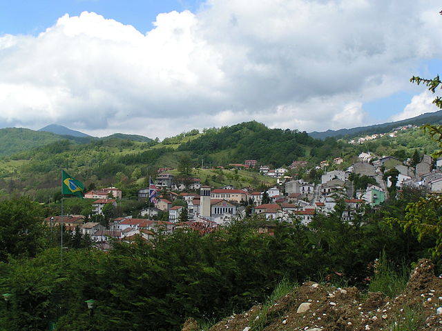
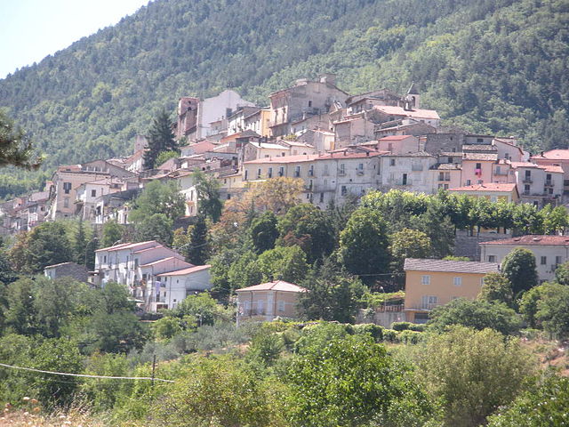
Пескокостанцо (Pescocostanzo, Pescocostanzo)
.svg)
- коммуна Италии
 Hiking in Пескокостанцо
Pescocostanzo is a charming village located in the Abruzzo region of Italy, nestled in the Apennine Mountains. It is a fantastic destination for hikers, offering a mix of stunning landscapes, historical sites, and a range of trails suitable for different skill levels.
Hiking Highlights in Pescocostanzo
-
Scenic Trails: The area is surrounded by beautiful natural parks, including the Majella National Park and the Abruzzo, Lazio and Molise National Park. You'll find a variety of trails that offer panoramic views of the mountains, valleys, and, in spring, vibrant wildflower meadows.
-
Historical Significance: Pescocostanzo itself is rich in history, with well-preserved medieval architecture. Some hiking routes take you through or near historical sites, allowing you to combine nature walks with cultural exploration.
-
Difficulty Levels: Trails vary from easy walks suitable for families to more challenging hikes for experienced trekkers. You can choose paths that are relatively flat, or tackle steeper climbs that reward you with breathtaking views.
-
Wildlife and Flora: As you hike, keep an eye out for local wildlife such as deer, foxes, and a variety of bird species. The flora includes unique species that thrive in this mountainous region.
-
Guided Tours: If you're unfamiliar with the area, consider joining a guided hiking tour. Local guides can provide valuable insights into the region's ecology and history.
-
Best Times to Visit: The ideal seasons for hiking in Pescocostanzo are late spring (May to June) and early autumn (September to October), when temperatures are mild, and the scenery is particularly beautiful.
-
Essential Preparation: Always check weather conditions before embarking on a hike, wear appropriate hiking boots, carry enough water, and bring a map or GPS device. It's also wise to inform someone of your hiking plans for safety.
Overall, Pescocostanzo offers a peaceful retreat for hiking enthusiasts, combining natural beauty with cultural richness.
- Страна:

- Почтовый код: 67033
- Телефонный код: 0864
- Код автомобильного номера: AQ
- Координаты: 41° 53' 14" N, 14° 3' 59" E


- GPS треки (wikiloc): [Ссылка]
- Высота над уровнем моря: 1395 м m
- Площадь: 55.06 кв.км
- Население: 1090
- Веб сайт: http://www.comune.pescocostanzo.aq.it/
- Википедия русская: wiki(ru)
- Википедия английская: wiki(en)
- Википедия национальная: wiki(it)
- Хранилище Wikidata: Wikidata: Q50123
- Катеория в википедии: [Ссылка]
- код Freebase: [/m/0fg7fm]
- код GeoNames: Альт: [6537437]
- код VIAF: Альт: [152522529]
- ID отношения в OpenStreetMap: [41608]
- идентификатор местоположения ArchINFORM: [6997]
- dmoz: Альт: [Regional/Europe/Italy/Abruzzo/Localities/Pescocostanzo/]
- Google Maps Customer ID: [17877745435828276093]
- код ISTAT: 066070
- кадастровый код Италии: G493
Граничит с регионами:

Ателета
- коммуна Италии
Hiking in Ателета
Ateleta, a charming town in the Abruzzo region of Italy, offers beautiful hiking opportunities characterized by stunning landscapes, picturesque views, and diverse trails. The surrounding area is part of the larger Maiella National Park, which is known for its rich biodiversity, rugged mountain terrain, and scenic vistas....
- Страна:
- Почтовый код: 67030
- Телефонный код: 0864
- Код автомобильного номера: AQ
- Координаты: 41° 51' 16" N, 14° 11' 56" E
- GPS треки (wikiloc): [Ссылка]
- Высота над уровнем моря: 760 м m
- Площадь: 41.93 кв.км
- Население: 1156
- Веб сайт: [Ссылка]


Кансано
- коммуна Италии
Hiking in Кансано
Cansano is a quaint village situated in the Abruzzo region of Italy, known for its picturesque landscapes and access to a variety of hiking trails. The area is characterized by rolling hills, lush forests, and stunning mountain views, making it a fantastic destination for outdoor enthusiasts....
- Страна:
- Почтовый код: 67030
- Телефонный код: 0864
- Код автомобильного номера: AQ
- Координаты: 42° 0' 19" N, 14° 0' 46" E
- GPS треки (wikiloc): [Ссылка]
- Высота над уровнем моря: 835 м m
- Площадь: 37.7 кв.км
- Население: 244
- Веб сайт: [Ссылка]

Петторано-суль-Джицио
- коммуна Италии
Hiking in Петторано-суль-Джицио
Pettorano sul Gizio is a charming village located in the province of L'Aquila in the Abruzzo region of Italy. Surrounded by the beautiful Apennine mountains, it offers numerous hiking opportunities, showcasing stunning landscapes, rich biodiversity, and fascinating historical sites....
- Страна:
- Почтовый код: 67034
- Телефонный код: 0864
- Код автомобильного номера: AQ
- Координаты: 41° 58' 32" N, 13° 57' 35" E
- GPS треки (wikiloc): [Ссылка]
- Высота над уровнем моря: 625 м m
- Площадь: 62.85 кв.км
- Население: 1414
- Веб сайт: [Ссылка]

Ривизондоли
- коммуна Италии
Hiking in Ривизондоли
Rivisondoli is a picturesque village located in the Abruzzo region of Italy, nestled in the stunning Apennine mountains. It's known for its natural beauty, making it an excellent destination for hiking enthusiasts. Here’s what you need to know about hiking in Rivisondoli:...
- Страна:
- Почтовый код: 67036
- Телефонный код: 0864
- Код автомобильного номера: AQ
- Координаты: 41° 52' 16" N, 14° 4' 3" E
- GPS треки (wikiloc): [Ссылка]
- Высота над уровнем моря: 1320 м m
- Площадь: 32 кв.км
- Население: 688
- Веб сайт: [Ссылка]


Рокка-Пия
- коммуна Италии
Hiking in Рокка-Пия
Rocca Pia is a picturesque village located in the Abruzzo region of Italy, surrounded by beautiful landscapes, mountains, and natural parks. It's a great destination for hiking enthusiasts, offering a variety of trails that cater to different skill levels....
- Страна:
- Почтовый код: 67030
- Телефонный код: 0864
- Код автомобильного номера: AQ
- Координаты: 41° 56' 4" N, 13° 58' 40" E
- GPS треки (wikiloc): [Ссылка]
- Высота над уровнем моря: 1181 м m
- Площадь: 44.96 кв.км
- Население: 176
- Веб сайт: [Ссылка]


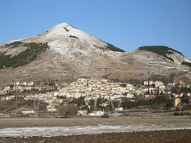
Роккаразо
- коммуна Италии
Hiking in Роккаразо
Roccaraso is a charming destination in the Apennine Mountains, located in the Abruzzo region of central Italy. Famous for its ski resorts in winter, it's also a fantastic location for hiking during the warmer months. Here are some key points to consider if you’re planning a hiking adventure in Roccaraso:...
- Страна:
- Почтовый код: 67037
- Телефонный код: 0864
- Код автомобильного номера: AQ
- Координаты: 41° 50' 48" N, 14° 4' 43" E
- GPS треки (wikiloc): [Ссылка]
- Высота над уровнем моря: 1236 м m
- Площадь: 49.91 кв.км
- Население: 1702
- Веб сайт: [Ссылка]


Палена
- коммуна Италии
Hiking in Палена
Palena, located in the Abruzzo region of Italy, is a hidden gem for hikers and nature enthusiasts. Nestled in the Majella National Park, it offers stunning landscapes, diverse flora and fauna, and a range of hiking trails suitable for all skill levels....
- Страна:
- Почтовый код: 66017
- Телефонный код: 0872
- Код автомобильного номера: CH
- Координаты: 41° 58' 54" N, 14° 8' 3" E
- GPS треки (wikiloc): [Ссылка]
- Высота над уровнем моря: 767 м m
- Площадь: 93.63 кв.км
- Население: 1332
- Веб сайт: [Ссылка]