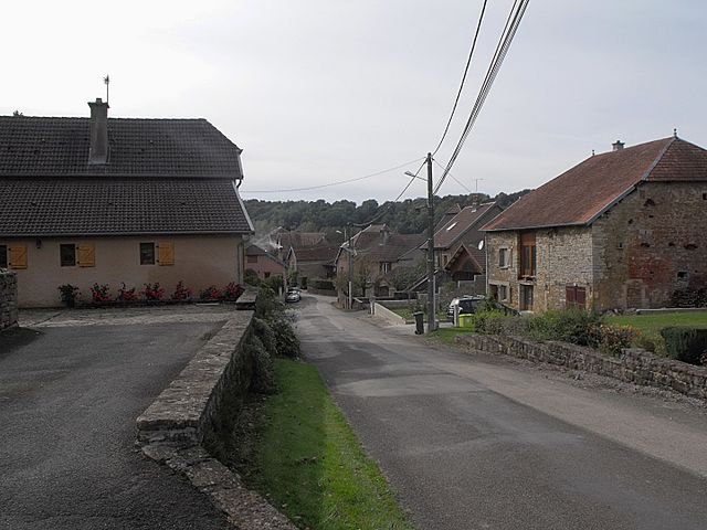
canton of Rougemont (canton de Rougemont)
 Hiking in canton of Rougemont
Canton de Rougemont is a picturesque region in Switzerland, known for its stunning landscapes, lush forests, and beautiful mountain vistas. This area provides an excellent backdrop for hiking enthusiasts of all levels, from beginners to experienced trekkers. Here’s what you need to know about hiking in this region:
Hiking Trails
-
Variety of Trails: The Canton de Rougemont offers a range of hiking trails, varying in difficulty and length. You can find leisurely walks through meadows and forests, as well as challenging hikes that go deep into the mountains.
-
Scenic Routes: Many trails provide breathtaking views of the surrounding Alps. Look out for paths that lead to vantage points where you can admire the iconic peaks.
-
Local Attractions: Certain hikes may take you to local attractions, such as charming villages, historic sites, and natural landmarks, allowing you to experience the culture and history of the area while hiking.
Best Times to Hike
- Summer: The best time for hiking is during the summer months (June to September) when the weather is generally mild, and the trails are well-maintained.
- Autumn: Early autumn (late September to October) offers beautiful fall colors, making hikes particularly scenic.
- Winter: If you enjoy snowshoeing or winter hiking, some trails may be accessible in winter, but be sure to check local conditions and prepare accordingly.
Preparation
- Maps and Guides: It's advisable to carry a detailed map or use a hiking app to navigate trails. Local tourism offices often provide brochures or advice on the best routes.
- Footwear and Gear: Proper hiking boots are essential, along with clothing suitable for changing mountain weather. Layering is key.
- Hydration and Snacks: Bring plenty of water and snacks to keep your energy up during the hike.
Safety
- Weather Conditions: Always check the weather forecast before heading out, as conditions can change rapidly in mountainous areas.
- Emergency Preparedness: Know the basics of first aid and carry a small emergency kit just in case.
Community and Events
- Local Hiking Clubs: Consider joining a local hiking group or tour, which can enhance your experience by providing guided walks and the opportunity to meet other hiking enthusiasts.
Conclusion
Hiking in Canton de Rougemont offers an unforgettable experience for those who love nature and the outdoors. With its diverse trails and breathtaking scenery, this region is a fantastic destination for both short day hikes and longer backpacking adventures. Always respect nature, stay on marked trails, and enjoy the beauty of the Alps!
- Страна:

- Столица: Rougemont
- Координаты: 47° 27' 11" N, 6° 21' 51" E


- GPS треки (wikiloc): [Ссылка]
- Хранилище Wikidata: Wikidata: Q1475849
- код кантона INSEE: [2523]
Включает регионы:


Uzelle
- коммуна во Франции
Hiking in Uzelle
Uzelle is a picturesque destination well-suited for hiking enthusiasts. Nestled in a natural environment that often boasts serene landscapes and diverse ecosystems, it presents various trails that cater to different skill levels. Here are some highlights to consider when hiking in Uzelle:...
- Страна:
- Почтовый код: 25340
- Координаты: 47° 27' 58" N, 6° 26' 10" E
- GPS треки (wikiloc): [Ссылка]
- Площадь: 11.75 кв.км
- Население: 171

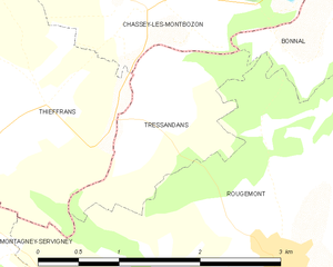
Tressandans
- коммуна во Франции
- Страна:
- Почтовый код: 25680
- Координаты: 47° 29' 53" N, 6° 20' 4" E
- GPS треки (wikiloc): [Ссылка]
- Площадь: 2.34 кв.км
- Население: 25

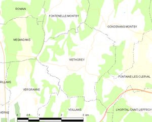
Viéthorey
- коммуна во Франции
Hiking in Viéthorey
Viéthorey is a picturesque village located in the Vosges region of France. This area is characterized by its stunning natural landscapes, making it a wonderful destination for hiking enthusiasts. Here are some key points to consider when planning a hiking trip in Viéthorey:...
- Страна:
- Почтовый код: 25340
- Координаты: 47° 25' 32" N, 6° 25' 46" E
- GPS треки (wikiloc): [Ссылка]
- Площадь: 7.92 кв.км
- Население: 95

Trouvans
- коммуна во Франции
Hiking in Trouvans
Trouvans, located in the beautiful French region of Bourgogne-Franche-Comté, offers a quaint and picturesque setting for hiking enthusiasts. While not as widely known as some other hiking destinations in France, it boasts scenic trails that are ideal for both beginners and more experienced hikers....
- Страна:
- Почтовый код: 25680
- Координаты: 47° 25' 24" N, 6° 20' 54" E
- GPS треки (wikiloc): [Ссылка]
- Площадь: 2.69 кв.км
- Население: 103


Tournans
- коммуна во Франции
Hiking in Tournans
Tournans is a beautiful area that offers a variety of hiking opportunities, showcasing its natural beauty and diverse landscapes. The region typically features scenic trails that can accommodate different skill levels, from beginner-friendly paths to more challenging routes for seasoned hikers....
- Страна:
- Почтовый код: 25680
- Координаты: 47° 24' 49" N, 6° 19' 39" E
- GPS треки (wikiloc): [Ссылка]
- Площадь: 9.14 кв.км
- Население: 132


Tallans
Hiking in Tallans
It seems you might be referring to a specific area or region, but I'm not familiar with "Tallans" as a recognized hiking destination. It's possible it could be a local name or a smaller area not widely known....
- Страна:
- Почтовый код: 25680
- Координаты: 47° 25' 13" N, 6° 17' 17" E
- GPS треки (wikiloc): [Ссылка]
- Площадь: 4.05 кв.км
- Население: 52