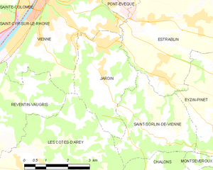
canton of Vienne-Sud (canton de Vienne-Sud)
 Hiking in canton of Vienne-Sud
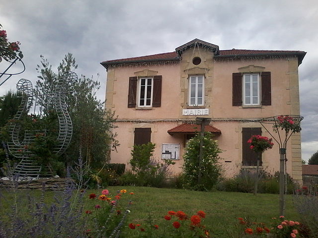
Canton de Vienne-Sud, located in the department of Isère in the Auvergne-Rhône-Alpes region of France, offers diverse landscapes and a range of hiking opportunities for outdoor enthusiasts. Here are some highlights you can expect when hiking in this area:
Scenic Trails
-
Varied Terrain: The region features a mix of rolling hills, valleys, and mountainous terrain. This variety allows for hikes suitable for different skill levels, from gentle walks to more challenging climbs.
-
Natural Parks: Close to the Canton de Vienne-Sud, you’ll find access to protected areas like the Parc naturel régional du Pilat, where you can enjoy numerous marked trails with breathtaking views of the surrounding landscape.
-
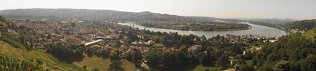
Rhône River Trails: The hiking trails along the Rhône River offer scenic views and opportunities to spot local wildlife. Strolling along the riverbanks is a relaxing way to experience the area's natural beauty.
Points of Interest
- Historical Sites: The region is rich in history, with opportunities to explore ancient ruins, Roman architecture, and charming villages.
- Château de La Roche: This historic castle offers a glimpse into the region's past and provides a beautiful backdrop for hikes in the area.
Local Tips
- Best Time to Hike: Spring and autumn are ideal for hiking in Canton de Vienne-Sud due to mild weather and stunning foliage.
- Trail Maps: Always carry a detailed map or use a reliable hiking app, as some trails may not be well-marked.
- Safety: Familiarize yourself with the terrain, carry plenty of water, wear appropriate footwear, and inform someone about your hiking plans.
Community and Resources
- Regional Hiking Clubs: Consider joining local hiking groups or clubs to meet fellow enthusiasts, discover new trails, and participate in organized hikes.
- Visitor Information Centers: Be sure to stop by local tourist offices for updated trail conditions, maps, and recommendations for the best hikes based on current weather and trail status.
Hiking in Canton de Vienne-Sud can be a rewarding experience filled with nature, culture, and adventure. Whether you’re an experienced hiker or a casual walker, this region has something for everyone to enjoy.
- Страна:

- Столица: Вьен
- Координаты: 45° 29' 2" N, 4° 53' 52" E


- GPS треки (wikiloc): [Ссылка]
- Хранилище Wikidata: Wikidata: Q787541
- код кантона INSEE: [3839]
Включает регионы:


Шонас-л'Амбаллан
- коммуна во Франции
- Страна:
- Почтовый код: 38121
- Координаты: 45° 27' 39" N, 4° 48' 42" E
- GPS треки (wikiloc): [Ссылка]
- Площадь: 7.41 кв.км
- Население: 1659
- Веб сайт: [Ссылка]


Ле-Кот-д'Аре
- коммуна во Франции
- Страна:
- Почтовый код: 38138
- Координаты: 45° 27' 21" N, 4° 52' 1" E
- GPS треки (wikiloc): [Ссылка]
- Площадь: 24.31 кв.км
- Население: 1983

Ле-Рош-де-Кондриё
- коммуна во Франции
- Страна:
- Почтовый код: 38370
- Координаты: 45° 27' 11" N, 4° 46' 4" E
- GPS треки (wikiloc): [Ссылка]
- Площадь: 1.03 кв.км
- Население: 2030
- Веб сайт: [Ссылка]


Сен-Сорлен-де-Вьенн
- коммуна во Франции
Hiking in Сен-Сорлен-де-Вьенн
Saint-Sorlin-de-Vienne is a charming commune located in the Auvergne-Rhône-Alpes region of France, offering a variety of hiking opportunities in a picturesque setting. Here are some highlights about hiking in this area:...
- Страна:
- Почтовый код: 38200
- Координаты: 45° 28' 4" N, 4° 56' 34" E
- GPS треки (wikiloc): [Ссылка]
- Высота над уровнем моря: 362 м m
- Площадь: 9.94 кв.км
- Население: 863

Ревантен-Вогри
- коммуна во Франции
- Страна:
- Почтовый код: 38121
- Координаты: 45° 28' 5" N, 4° 50' 27" E
- GPS треки (wikiloc): [Ссылка]
- Площадь: 18.4 кв.км
- Население: 1785
- Веб сайт: [Ссылка]


Эстраблен
- коммуна во Франции
Hiking in Эстраблен
Estrablin, located in the Auvergne-Rhône-Alpes region of southeastern France, offers a charming landscape for hiking enthusiasts. Whether you are looking for a leisurely stroll or a more challenging trek, the area provides various trails that allow hikers to explore the natural beauty around....
- Страна:
- Почтовый код: 38780
- Координаты: 45° 31' 1" N, 4° 57' 53" E
- GPS треки (wikiloc): [Ссылка]
- Площадь: 20.69 кв.км
- Население: 3296


Муадьё-Детурб
- коммуна во Франции
Hiking in Муадьё-Детурб
Moidieu-Détourbe is a scenic municipality located in the Auvergne-Rhône-Alpes region of France, near the Rhône River. While it might not be as widely known as some other hiking destinations, it offers a beautiful landscape perfect for exploration....
- Страна:
- Почтовый код: 38440
- Координаты: 45° 30' 43" N, 5° 0' 58" E
- GPS треки (wikiloc): [Ссылка]
- Площадь: 18.04 кв.км
- Население: 1832
- Веб сайт: [Ссылка]
Вьен
- коммуна во Франции
- Страна:
- Почтовый код: 38200
- Координаты: 45° 31' 32" N, 4° 52' 29" E
- GPS треки (wikiloc): [Ссылка]
- Высота над уровнем моря: 169 м m
- Площадь: 22.65 кв.км
- Население: 29162
- Веб сайт: [Ссылка]
Жарден
- коммуна во Франции
Hiking in Жарден
Jardin, located in the Isère department of the Auvergne-Rhône-Alpes region in southeastern France, is a lesser-known gem for hiking enthusiasts. The area is characterized by its picturesque landscapes, lush forests, and stunning mountain vistas, making it ideal for outdoor activities....
- Страна:
- Почтовый код: 38200
- Координаты: 45° 29' 47" N, 4° 54' 30" E
- GPS треки (wikiloc): [Ссылка]
- Площадь: 9.25 кв.км
- Население: 2211
- Веб сайт: [Ссылка]


Эзен-Пинет
- коммуна во Франции
Hiking in Эзен-Пинет
Eyzin-Pinet is a charming commune in the Isère department of France, located near the picturesque Rhône-Alpes region. While it may not be as famous as some other hiking destinations in the area, it offers beautiful landscapes and a chance to experience the natural beauty of the surrounding countryside....
- Страна:
- Почтовый код: 38780
- Координаты: 45° 28' 23" N, 4° 59' 56" E
- GPS треки (wikiloc): [Ссылка]
- Площадь: 28.44 кв.км
- Население: 2204
- Веб сайт: [Ссылка]