canton of Bouchoux (canton des Bouchoux)
 Hiking in canton of Bouchoux
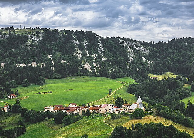
Canton des Bouchoux is a picturesque area in France, located in the Jura region, known for its lush landscapes, rolling hills, and beautiful natural scenery. Here’s what you can expect when hiking in this region:
Trails and Routes
- Diverse Terrain: The trails vary from easy walks to more challenging hikes, accommodating all levels of hikers.
- Signposted Paths: Many trails are well-marked, allowing for easy navigation. It's advisable to carry a map or use a GPS to stay on track.
- Scenic Views: Hikes often offer panoramic views of the Jura Mountains and the surrounding countryside, particularly rewarding during sunrise or sunset.
Flora and Fauna
- Rich Biodiversity: The area is home to diverse plant species and wildlife, including deer, various birds, and unique wildflowers.
- Seasonal Changes: Each season brings different colors and landscapes, making it worthwhile to hike at various times of the year.
Cultural and Historical Aspects
- Rural Charm: You might encounter quaint villages and local farms along the way, providing insight into the region's culture and traditions.
- Historic Points of Interest: Some trails might lead to historical sites or natural landmarks that reflect the rich heritage of the Jura region.
Safety and Preparation
- Weather Awareness: The weather can change rapidly, so it's essential to check forecasts and be prepared for sudden changes.
- Footwear and Gear: Sturdy hiking boots and appropriate clothing for the weather are crucial. Ensure you are equipped with water, snacks, and a first aid kit.
- Local Regulations: Familiarize yourself with any local regulations regarding hiking and nature conservation before your trek.
Best Times to Hike
- Spring and Autumn: These seasons are particularly beautiful for hiking, with mild temperatures and stunning foliage.
- Summer: While great for long hikes, be prepared for warmer weather and ensure proper hydration.
Accessibility
Canton des Bouchoux is accessible by public transport and has parking facilities for those driving. Be sure to check local resources for trail maps and starting points.
Overall, hiking in the Canton des Bouchoux offers a wonderful opportunity to connect with nature, experience beautiful landscapes, and enjoy the tranquility that this serene region has to offer.
- Страна:

- Столица: Les Bouchoux
- Координаты: 46° 19' 10" N, 5° 49' 1" E


- GPS треки (wikiloc): [Ссылка]
- Хранилище Wikidata: Wikidata: Q1472751
- код кантона INSEE: [3905]
Включает регионы:


Rogna
- коммуна во Франции
Hiking in Rogna
I believe you might be referring to "Rognan," which is a village in Norway, located in the municipality of Råde. If that's correct, hiking in the region can offer a variety of landscapes, including forests, lakes, and coastal areas. Here are some details you might find useful:...
- Страна:
- Почтовый код: 39360
- Координаты: 46° 19' 36" N, 5° 44' 54" E
- GPS треки (wikiloc): [Ссылка]
- Площадь: 10.46 кв.км
- Население: 225


Viry
Hiking in Viry
Viry, located in the Jura region of France, offers stunning landscapes and diverse hiking opportunities. The Jura is characterized by its rolling hills, forests, and picturesque valleys, making it an excellent destination for nature lovers and outdoor enthusiasts....
- Страна:
- Почтовый код: 39360
- Координаты: 46° 18' 0" N, 5° 44' 18" E
- GPS треки (wikiloc): [Ссылка]
- Высота над уровнем моря: 750 м m
- Площадь: 25.4 кв.км
- Население: 948
- Веб сайт: [Ссылка]

Les Bouchoux
- коммуна во Франции
Hiking in Les Bouchoux
Les Bouchoux, a picturesque village located in the Jura region of France, offers a unique hiking experience marked by stunning landscapes, rich biodiversity, and a charming rural atmosphere. Here are some key points to know about hiking in this area:...
- Страна:
- Почтовый код: 39370
- Координаты: 46° 17' 49" N, 5° 49' 9" E
- GPS треки (wikiloc): [Ссылка]
- Площадь: 21.71 кв.км
- Население: 316


Choux
- коммуна во Франции
Hiking in Choux
It seems like there might be a typo or misunderstanding in your question regarding "Choux." If you're referring to a specific location or region for hiking, could you provide a little more detail?...
- Страна:
- Почтовый код: 39370
- Координаты: 46° 18' 18" N, 5° 46' 6" E
- GPS треки (wikiloc): [Ссылка]
- Площадь: 8.27 кв.км
- Население: 119


La Pesse
- коммуна во Франции
Hiking in La Pesse
La Pesse is a charming village located in the Jura Mountains of France, known for its scenic landscapes and natural beauty, making it a great destination for hiking enthusiasts. Here are some details you might find helpful if you're considering hiking in this area:...
- Страна:
- Почтовый код: 39370
- Координаты: 46° 17' 8" N, 5° 50' 52" E
- GPS треки (wikiloc): [Ссылка]
- Площадь: 24.26 кв.км
- Население: 356
- Веб сайт: [Ссылка]


Bellecombe
- коммуна во Франции
Hiking in Bellecombe
Bellecombe is a picturesque area in the Alps, offering a range of hiking opportunities for all levels of experience. Nestled in stunning natural scenery, it provides a great backdrop for outdoor activities. Here are some key details about hiking in Bellecombe:...
- Страна:
- Почтовый код: 39310
- Координаты: 46° 19' 27" N, 5° 55' 20" E
- GPS треки (wikiloc): [Ссылка]
- Высота над уровнем моря: 1200 м m
- Площадь: 12.17 кв.км
- Население: 65
- Веб сайт: [Ссылка]


Coyrière
- коммуна во Франции
Hiking in Coyrière
Coyrière is a lesser-known hiking destination that typically offers beautiful landscapes and a chance to connect with nature. While I don't have specifics on Coyrière, I can provide you with general information that often applies to hiking in similar regions....
- Страна:
- Почтовый код: 39200
- Координаты: 46° 20' 34" N, 5° 50' 37" E
- GPS треки (wikiloc): [Ссылка]
- Площадь: 4.11 кв.км
- Население: 66


Coiserette
- коммуна во Франции
Hiking in Coiserette
Coiserette is not a widely recognized hiking destination, and it could refer to a specific local area or park that is not extensively documented in popular hiking resources. It's possible it's a small village or area, potentially in France, as similar names hint toward that....
- Страна:
- Почтовый код: 39200
- Координаты: 46° 20' 31" N, 5° 50' 2" E
- GPS треки (wikiloc): [Ссылка]
- Площадь: 5.91 кв.км
- Население: 53


Vulvoz
- коммуна во Франции
Hiking in Vulvoz
It seems there may be a typo or misunderstanding in your request, as "Vulvoz" does not appear to correspond to any well-known hiking destination or location. If you're referring to a specific hiking area, perhaps you meant "Vulcan" or "Val d'Ossola" or another similar sounding name?...
- Страна:
- Почтовый код: 39360
- Координаты: 46° 19' 39" N, 5° 47' 22" E
- GPS треки (wikiloc): [Ссылка]
- Площадь: 4.49 кв.км
- Население: 18


Les Moussières
- коммуна во Франции
Hiking in Les Moussières
Les Moussières is a beautiful hiking destination situated in the French Jura Mountains, renowned for its stunning landscapes, rich biodiversity, and charming rural atmosphere. Here are some key points to consider if you're planning to hike in the area:...
- Страна:
- Почтовый код: 39310
- Координаты: 46° 19' 33" N, 5° 53' 24" E
- GPS треки (wikiloc): [Ссылка]
- Площадь: 16.95 кв.км
- Население: 168


Larrivoire
- коммуна во Франции
Hiking in Larrivoire
Larrivoire, often referred to as a picturesque region in the French Alps, offers a range of hiking opportunities for enthusiasts of all experience levels. The scenic beauty, featuring stunning mountain vistas, lush valleys, and flowing streams, makes it an attractive destination for nature lovers....
- Страна:
- Почтовый код: 39360
- Координаты: 46° 20' 37" N, 5° 47' 16" E
- GPS треки (wikiloc): [Ссылка]
- Площадь: 6.5 кв.км
- Население: 116