La Pesse (La Pesse)

- коммуна во Франции
 Hiking in La Pesse
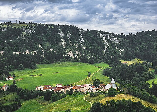
La Pesse is a charming village located in the Jura Mountains of France, known for its scenic landscapes and natural beauty, making it a great destination for hiking enthusiasts. Here are some details you might find helpful if you're considering hiking in this area:
Trails and Routes
- Variety of Trails: La Pesse offers a variety of hiking trails suitable for different skill levels, from easy walks ideal for families to more challenging routes for experienced hikers.
- Scenic Views: Hikes in the region typically provide stunning vistas of the Jura peaks and lush valleys. Be prepared to see beautiful forests, meadows, and possibly some local wildlife.
- Marked Paths: Many trails are well-marked, making navigation straightforward. It’s advisable to carry a map of the area or use a GPS device, as conditions can change.
Tips for Hiking in La Pesse
- Seasonal Considerations: The best time for hiking is generally between late spring and early autumn, when the weather is mild. Winter can bring snow, making certain trails less accessible but also providing opportunities for snowshoeing.
- Proper Gear: Make sure to wear appropriate footwear and clothing suitable for both the terrain and weather conditions. Layering is encouraged due to the possibility of changing conditions.
- Local Regulations: Always respect local wildlife and plant life. Following local guidelines helps preserve the natural beauty of the area.
- Hydration and Nutrition: Carry enough water and snacks, especially for longer hikes. There may be limited opportunities to refill water or buy food along the trails.
Points of Interest
- Cultural Stops: Explore the local culture and perhaps visit nearby farms or artisan shops known for producing local products, which can enhance your hiking experience.
- Wildlife Spotting: Keep an eye out for the diverse fauna in the area, including deer, various bird species, and other local wildlife during your hike.
Safety Considerations
- Weather Awareness: Always check the weather forecast before heading out. Sudden changes can occur in mountainous areas.
- Hike with a Buddy: It’s generally safer to hike with a companion, and it can also enhance the experience.
Hiking in La Pesse provides a wonderful opportunity to immerse yourself in nature while enjoying the unique beauty and peacefulness of the Jura region. Enjoy your hike!
- Страна:

- Почтовый код: 39370
- Координаты: 46° 17' 8" N, 5° 50' 52" E


- GPS треки (wikiloc): [Ссылка]
- Площадь: 24.26 кв.км
- Население: 356
- Веб сайт: http://www.mairie-la-pesse.com
- Википедия английская: wiki(en)
- Википедия национальная: wiki(fr)
- Хранилище Wikidata: Wikidata: Q629501
- Катеория в википедии: [Ссылка]
- код Freebase: [/m/03npvyz]
- код GeoNames: Альт: [6455985]
- номер SIREN: [213904139]
- код BNF: [15258776b]
- код LCNAF: Альт: [n96011273]
- WOEID: [599357]
- код муниципалитета INSEE: 39413
Граничит с регионами:


Шанфромье
- коммуна во Франции
Hiking in Шанфромье
Champfromier is a charming village located in the Ain department of the Auvergne-Rhône-Alpes region in eastern France. It's a fantastic base for hikers looking to explore the beautiful landscapes of the Jura Mountains, which offer a variety of trails suited for different skill levels....
- Страна:
- Почтовый код: 01410
- Координаты: 46° 11' 38" N, 5° 49' 0" E
- GPS треки (wikiloc): [Ссылка]
- Площадь: 32.4 кв.км
- Население: 735

Белледу
- коммуна во Франции
Hiking in Белледу
Belleydoux is a picturesque village located in the Jura region of France, known for its stunning natural landscapes and outdoor recreational opportunities. Hiking in this area can be a fantastic experience, offering a combination of beautiful scenery, diverse terrains, and rich biodiversity....
- Страна:
- Почтовый код: 01130
- Координаты: 46° 15' 9" N, 5° 46' 39" E
- GPS треки (wikiloc): [Ссылка]
- Площадь: 17.63 кв.км
- Население: 315
- Веб сайт: [Ссылка]

Шезери-Форан
- коммуна во Франции
Hiking in Шезери-Форан
Chézery-Forens is a charming commune located in the Ain department in the Auvergne-Rhône-Alpes region of southeastern France. Known for its beautiful natural landscapes, it is a fantastic spot for hiking and exploring the great outdoors. Here are some key highlights about hiking in and around Chézery-Forens:...
- Страна:
- Почтовый код: 01200
- Координаты: 46° 13' 18" N, 5° 51' 59" E
- GPS треки (wikiloc): [Ссылка]
- Площадь: 46.57 кв.км
- Население: 460
- Веб сайт: [Ссылка]

Les Bouchoux
- коммуна во Франции
Hiking in Les Bouchoux
Les Bouchoux, a picturesque village located in the Jura region of France, offers a unique hiking experience marked by stunning landscapes, rich biodiversity, and a charming rural atmosphere. Here are some key points to know about hiking in this area:...
- Страна:
- Почтовый код: 39370
- Координаты: 46° 17' 49" N, 5° 49' 9" E
- GPS треки (wikiloc): [Ссылка]
- Площадь: 21.71 кв.км
- Население: 316


Bellecombe
- коммуна во Франции
Hiking in Bellecombe
Bellecombe is a picturesque area in the Alps, offering a range of hiking opportunities for all levels of experience. Nestled in stunning natural scenery, it provides a great backdrop for outdoor activities. Here are some key details about hiking in Bellecombe:...
- Страна:
- Почтовый код: 39310
- Координаты: 46° 19' 27" N, 5° 55' 20" E
- GPS треки (wikiloc): [Ссылка]
- Высота над уровнем моря: 1200 м m
- Площадь: 12.17 кв.км
- Население: 65
- Веб сайт: [Ссылка]


Coiserette
- коммуна во Франции
Hiking in Coiserette
Coiserette is not a widely recognized hiking destination, and it could refer to a specific local area or park that is not extensively documented in popular hiking resources. It's possible it's a small village or area, potentially in France, as similar names hint toward that....
- Страна:
- Почтовый код: 39200
- Координаты: 46° 20' 31" N, 5° 50' 2" E
- GPS треки (wikiloc): [Ссылка]
- Площадь: 5.91 кв.км
- Население: 53


Les Moussières
- коммуна во Франции
Hiking in Les Moussières
Les Moussières is a beautiful hiking destination situated in the French Jura Mountains, renowned for its stunning landscapes, rich biodiversity, and charming rural atmosphere. Here are some key points to consider if you're planning to hike in the area:...
- Страна:
- Почтовый код: 39310
- Координаты: 46° 19' 33" N, 5° 53' 24" E
- GPS треки (wikiloc): [Ссылка]
- Площадь: 16.95 кв.км
- Население: 168