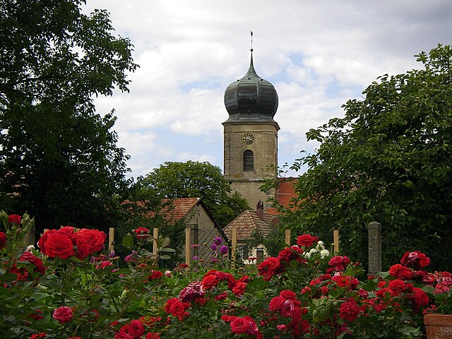
Серне (canton of Cernay, canton de Cernay)

 Hiking in Серне
The Canton of Cernay, located in the Alsace region of France, is a fantastic destination for hiking enthusiasts. The area's diverse terrain features lush forests, gentle hills, and stunning views of the Vosges Mountains. Here are some highlights and tips for hiking in this picturesque region:
Trails and Routes
-
Local Trails: There are numerous marked trails suitable for different skill levels. These include easy walks for families and more challenging hikes for experienced trekkers. The trails can often be found by local tourist offices or through hiking apps.
-
Sentier des Moulins: This trail takes you through beautiful and serene landscapes, showcasing the traditional watermills that were once key to the local economy.
-
Vosges Mountains: For those looking for more rugged experiences, head to the nearby Vosges Mountains, which offer more challenging hikes with breathtaking panoramas.
-
Circuit des 3 Châteaux: A popular hike that leads to the ruins of three historic castles and provides captivating views of the surrounding landscape.
Nature and Scenery
The Canton of Cernay is rich in biodiversity, with many opportunities to see wildlife, particularly in the forested areas. The scenery varies from lush green valleys to rocky outcrops and peaceful streams, making it visually rewarding throughout the year.
Best Times to Hike
- Spring and Fall: Mild temperatures and blooming nature make these seasons ideal for hiking.
- Summer: Great for long hikes but be sure to hydrate and protect yourself from the sun.
- Winter: Some trails in the Vosges may be suitable for snowshoeing or winter hiking, but always check trail conditions and be prepared.
Preparation and Safety
- Gear: Wear appropriate hiking shoes and clothing, and bring enough water and snacks.
- Map and Navigation: While trails are often well-marked, having a map or using a hiking app can help you stay oriented.
- Weather: Check the weather forecast before heading out, as conditions can change quickly in mountainous regions.
Local Recommendations
- Accommodations: Consider staying in a local bed and breakfast or a gîte (holiday home) to fully immerse yourself in the Alsatian culture.
- Local Cuisine: Don’t miss trying out traditional Alsatian dishes in nearby towns after a day of hiking.
Exploring the Canton of Cernay through hiking can offer a wonderful way to connect with nature, experience local culture, and enjoy spectacular landscapes. Happy hiking!
- Страна:

- Столица: Серне
- Координаты: 47° 49' 0" N, 7° 10' 0" E


- GPS треки (wikiloc): [Ссылка]
- Население: 50392
- Википедия русская: wiki(ru)
- Википедия английская: wiki(en)
- Википедия национальная: wiki(fr)
- Хранилище Wikidata: Wikidata: Q953478
- код LCNAF: Альт: [n2007043733]
- код кантона INSEE: [6803]
Включает регионы:


Серне
- Страна:
- Почтовый код: 68700
- Координаты: 47° 48' 24" N, 7° 10' 33" E
- GPS треки (wikiloc): [Ссылка]
- Площадь: 18.04 кв.км
- Население: 11608
- Веб сайт: [Ссылка]


Аспак-ле-Ба
- коммуна во Франции
- Страна:
- Почтовый код: 68700
- Координаты: 47° 45' 42" N, 7° 9' 2" E
- GPS треки (wikiloc): [Ссылка]
- Площадь: 8.01 кв.км
- Население: 1323

Бернвиллер
- коммуна во Франции
Hiking in Бернвиллер
Bernwiller is a charming village located in the Alsace region of France, near Mulhouse. The surrounding area is known for its picturesque landscapes, rolling hills, and vineyards, making it an appealing destination for hiking enthusiasts....
- Страна:
- Почтовый код: 68210
- Координаты: 47° 41' 29" N, 7° 11' 27" E
- GPS треки (wikiloc): [Ссылка]
- Площадь: 10.65 кв.км
- Население: 687

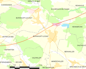
Бюрно-ле-Ба
- коммуна во Франции
Hiking in Бюрно-ле-Ба
Burnhaupt-le-Bas is a charming village located in the Alsace region of northeastern France, known for its rich natural scenery and beautiful hiking opportunities. While it may not be as widely recognized as some of the larger hiking destinations in the region, it offers several attractive trails and is a great starting point for outdoor activities....
- Страна:
- Почтовый код: 68520
- Координаты: 47° 43' 4" N, 7° 9' 42" E
- GPS треки (wikiloc): [Ссылка]
- Площадь: 11.77 кв.км
- Население: 1849
- Веб сайт: [Ссылка]


Бюрно-ле-О
- коммуна во Франции
Hiking in Бюрно-ле-О
Burnhaupt-le-Haut is a small commune located in the Alsace region of northeastern France. It offers picturesque landscapes and opportunities for hiking enthusiasts to explore the surrounding natural beauty....
- Страна:
- Почтовый код: 68520
- Координаты: 47° 43' 49" N, 7° 8' 43" E
- GPS треки (wikiloc): [Ссылка]
- Площадь: 12.49 кв.км
- Население: 1807


Уффольтс
- коммуна во Франции
- Страна:
- Почтовый код: 68700
- Координаты: 47° 49' 13" N, 7° 10' 44" E
- GPS треки (wikiloc): [Ссылка]
- Площадь: 11.91 кв.км
- Население: 1701


Ваттвиллер
- коммуна во Франции
- Страна:
- Почтовый код: 68700
- Координаты: 47° 50' 11" N, 7° 10' 48" E
- GPS треки (wikiloc): [Ссылка]
- Площадь: 13.61 кв.км
- Население: 1656
- Веб сайт: [Ссылка]

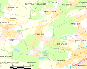
Виттельсайм
- коммуна во Франции
- Страна:
- Почтовый код: 68310
- Координаты: 47° 48' 19" N, 7° 14' 15" E
- GPS треки (wikiloc): [Ссылка]
- Площадь: 23.63 кв.км
- Население: 10384
- Веб сайт: [Ссылка]


Швегуз-Тан
- коммуна во Франции
Hiking in Швегуз-Тан
Schweighouse-Thann is located in the Alsace region of France, near the Vosges Mountains. It's a beautiful area that offers a variety of hiking opportunities catering to different skill levels, from leisurely walks to more challenging hikes....
- Страна:
- Почтовый код: 68520
- Координаты: 47° 45' 10" N, 7° 10' 15" E
- GPS треки (wikiloc): [Ссылка]
- Высота над уровнем моря: 380 м m
- Площадь: 10.78 кв.км
- Население: 778

Стаффельфельден
- коммуна во Франции
- Страна:
- Почтовый код: 68850
- Координаты: 47° 49' 36" N, 7° 15' 11" E
- GPS треки (wikiloc): [Ссылка]
- Площадь: 7.42 кв.км
- Население: 3911


Стенбак
- коммуна во Франции
- Страна:
- Почтовый код: 68700
- Координаты: 47° 49' 14" N, 7° 9' 8" E
- GPS треки (wikiloc): [Ссылка]
- Площадь: 6.09 кв.км
- Население: 1362
- Веб сайт: [Ссылка]