canton of Châtenois-les-Forges (canton de Châtenois-les-Forges)

 Hiking in canton of Châtenois-les-Forges
Canton of Châtenois-les-Forges, located in the Vosges department in the Grand Est region of France, offers beautiful hiking opportunities with a mix of natural beauty and cultural heritage. Here are some key highlights for hiking in this area:
Scenic Trails
-
Voges Mountain Trails: Explore the picturesque trails in the nearby Vosges mountains. The elevation provides stunning views and varied landscapes, including forests, pastures, and panoramic vistas.
-
GR 5 Trail: This long-distance hiking trail runs through the region, offering hikers a chance to experience the diverse environments of the Vosges. The western part of the trail features several itineraries that can be explored during day hikes.
Important Tips
- Local Maps: It’s wise to obtain a local hiking map from tourist information centers or online resources to navigate the trails effectively.
- Weather Check: Always check the weather forecast before heading out, as conditions can change rapidly in mountainous areas.
- Proper Gear: Ensure you have appropriate hiking gear, including sturdy boots, layers of clothing, and enough water and snacks.
Nearby Attractions
-
Château de Châtenois: While hiking, consider visiting local historical sites, such as the ruins of the Château de Châtenois, which offers a glimpse into the region's history and adds a cultural dimension to your hike.
-
Natural Reserves: Look for nearby natural reserves or parks, where you can see local wildlife and participate in guided hikes, which can enhance your experience.
-
Local Cuisine: After a rewarding hike, enjoy local cuisine in the small towns, featuring specialties from the Vosges region, like tarte flambée or local cheeses.
Trail Markings
Trails are generally well-marked with colored blaze signs. Familiarize yourself with these markers to ensure you stay on the right path.
Hiking in the Canton of Châtenois-les-Forges can be a delightful experience, combining nature with local culture and history. Always remember to respect the environment and local wildlife during your hikes. Happy hiking!
- Страна:

- Столица: Châtenois-les-Forges
- Координаты: 47° 35' 33" N, 6° 49' 57" E


- GPS треки (wikiloc): [Ссылка]
- Население: 14550
- Википедия английская: wiki(en)
- Википедия национальная: wiki(fr)
- Хранилище Wikidata: Wikidata: Q1398301
- код кантона INSEE: [9005]
Включает регионы:


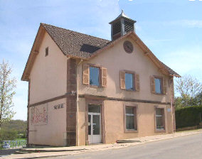
Dorans
- коммуна во Франции
Hiking in Dorans
Dorans is not a well-known hiking destination, and there may be limited information readily available. However, I can provide some general tips and advice for hiking in lesser-known areas, which could be useful if you're considering hiking in a location named Dorans or a similar locality....
- Страна:
- Почтовый код: 90400
- Координаты: 47° 35' 16" N, 6° 50' 19" E
- GPS треки (wikiloc): [Ссылка]
- Площадь: 3.77 кв.км
- Население: 718
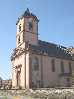

Châtenois-les-Forges
- коммуна во Франции
Hiking in Châtenois-les-Forges
Châtenois-les-Forges is a charming village located in the Vosges department of northeastern France. It's surrounded by beautiful natural landscapes, making it a great spot for hiking enthusiasts. Here are some key points about hiking in this area:...
- Страна:
- Почтовый код: 90700
- Координаты: 47° 33' 33" N, 6° 50' 54" E
- GPS треки (wikiloc): [Ссылка]
- Площадь: 8.67 кв.км
- Население: 2757

Argiésans
- коммуна во Франции
Hiking in Argiésans
Argiésans is a picturesque region known for its stunning natural landscapes, making it an excellent destination for hiking enthusiasts. Nestled in the heart of the Pyrenees, this area offers a variety of trails that cater to different skill levels, from gentle walks to challenging climbs....
- Страна:
- Почтовый код: 90800
- Координаты: 47° 36' 14" N, 6° 49' 22" E
- GPS треки (wikiloc): [Ссылка]
- Площадь: 2.73 кв.км
- Население: 433


Banvillars
- коммуна во Франции
Hiking in Banvillars
Banvillars is a small village located in the Bourgogne-Franche-Comté region of France, known for its picturesque countryside and natural beauty. While it may not be as famous as some of the larger hiking destinations, it offers a unique and charming experience for hikers looking to explore the serene landscapes of eastern France....
- Страна:
- Почтовый код: 90800
- Координаты: 47° 35' 32" N, 6° 48' 53" E
- GPS треки (wikiloc): [Ссылка]
- Площадь: 4.67 кв.км
- Население: 283
- Веб сайт: [Ссылка]


Botans
- коммуна во Франции
Hiking in Botans
It looks like you might be referring to a specific location or region, but "Botans" doesn’t seem to align with any widely recognized hiking area or trail system as of my last knowledge update in October 2023. It’s possible that it could be a misspelling or a less-known local name....
- Страна:
- Почтовый код: 90400
- Координаты: 47° 35' 48" N, 6° 51' 1" E
- GPS треки (wikiloc): [Ссылка]
- Площадь: 2.29 кв.км
- Население: 263

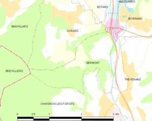
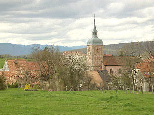
Bermont
- коммуна во Франции
Hiking in Bermont
Bermont, located in the state of Florida, offers a variety of hiking opportunities that are perfect for both beginner and experienced hikers. While it may not be as well-known for its hiking trails as some other destinations, there are several nearby areas worth exploring, particularly if you enjoy more rural and natural settings....
- Страна:
- Почтовый код: 90400
- Координаты: 47° 34' 48" N, 6° 51' 12" E
- GPS треки (wikiloc): [Ссылка]
- Площадь: 2.74 кв.км
- Население: 391


Bavilliers
- коммуна во Франции
Hiking in Bavilliers
Bavilliers, a small commune located in the Bourgogne-Franche-Comté region of France, offers a charming backdrop for those interested in hiking. While it may not be as renowned as some larger hiking locales, it provides a unique opportunity to explore the surrounding natural landscapes....
- Страна:
- Почтовый код: 90800
- Координаты: 47° 37' 10" N, 6° 49' 50" E
- GPS треки (wikiloc): [Ссылка]
- Площадь: 4.8 кв.км
- Население: 4826
- Веб сайт: [Ссылка]

Buc
- коммуна во Франции
Hiking in Buc
Buc, located in the Territoire de Belfort department in the Bourgogne-Franche-Comté region of France, offers varying hiking opportunities that showcase the beautiful natural landscapes of the area. While Buc itself may not be a well-known hiking destination, its proximity to the Vosges Mountains and the Ballons des Vosges Regional Natural Park provides many trails ideal for hiking enthusiasts....
- Страна:
- Почтовый код: 90800
- Координаты: 47° 36' 53" N, 6° 47' 7" E
- GPS треки (wikiloc): [Ссылка]
- Площадь: 2.44 кв.км
- Население: 294


Trévenans
- коммуна во Франции
Hiking in Trévenans
Trévenans is a small commune located in the Bourgogne-Franche-Comté region of France, near Montbéliard. While it may not be as widely recognized as other hiking destinations, it offers some beautiful natural scenery and opportunities for outdoor exploration....
- Страна:
- Почтовый код: 90400
- Координаты: 47° 34' 15" N, 6° 51' 43" E
- GPS треки (wikiloc): [Ссылка]
- Площадь: 5.96 кв.км
- Население: 1207


Urcerey
- коммуна во Франции
Hiking in Urcerey
Urcerey is not a widely recognized hiking destination, so it might refer to a specific area with local interest or a less-known name. However, if you meant a popular hiking area or trail with a name similar to Urcerey, please clarify....
- Страна:
- Почтовый код: 90800
- Координаты: 47° 36' 29" N, 6° 48' 33" E
- GPS треки (wikiloc): [Ссылка]
- Площадь: 3.39 кв.км
- Население: 215