Турнон-сюр-Рон (canton of Tournon-sur-Rhône, canton de Tournon-sur-Rhône)

 Hiking in Турнон-сюр-Рон
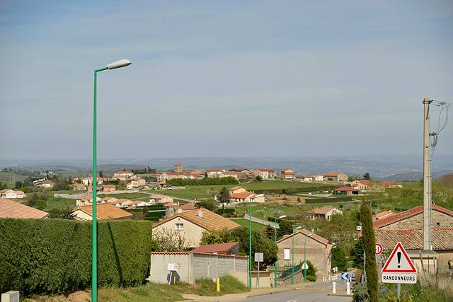
The Canton of Tournon-sur-Rhône, located in the Auvergne-Rhône-Alpes region of France, offers a variety of hiking opportunities that cater to different skill levels and preferences. This picturesque area is characterized by its beautiful landscapes, vineyards, and proximity to the Rhône River, making it an ideal destination for outdoor enthusiasts.
Key Features of Hiking in Tournon-sur-Rhône:
-
Scenic Trails: The region is known for its diverse hiking trails that wind through vineyards, forests, and along riverbanks, offering stunning views of the Rhône Valley and the surrounding hills.
-
Varied Terrain: Hikers can experience different terrains, from gentle, rolling hills suited for families and casual walkers to more challenging routes for experienced hikers looking for a workout and adventure.
-
Cultural Attractions: Along many trails, you can discover historical sites, such as ancient chateaux, traditional villages, and the charming town of Tournon-sur-Rhône itself, with its rich heritage and wine culture.
-
Wine Trails: The region is renowned for its vineyards, particularly the wines of the Northern Rhône. Some hiking routes may lead through the vineyards, allowing hikers to explore the local viticulture and perhaps stop for tastings.
-
Wildlife Observation: The diverse ecosystems in the area provide opportunities for birdwatching and observing local wildlife, particularly in the natural reserves nearby.
-
Regional Parks: Nearby protected areas and regional parks offer organized trails and guided hikes, providing a chance to learn about flora and fauna.
Recommended Hiking Routes:
-
Les Côtes de Tournon: A popular option for experiencing the vineyards directly, this route often includes wine-tasting stops and great views of the Rhône River.
-
Sentier du Dolmen: A family-friendly trail that is easy to navigate and leads to historical sites, including dolmens, showcasing the area's ancient past.
-
Monts d'Ardèche: For more adventurous hikers, routes in the nearby Monts d'Ardèche offer challenging ascents, rugged landscapes, and breathtaking panoramic views.
Tips for Hiking in Tournon-sur-Rhône:
-
Check Trail Conditions: Before heading out, check local trail maps and conditions, as weather can affect accessibility.
-
Hydration and Snacks: Bring plenty of water and snacks, especially on longer hikes where facilities may be limited.
-
Respect Nature: Follow the Leave No Trace principles to preserve the beauty of the natural environment.
-
Local Guides: Consider hiring a local guide if you want a more enriching experience with insights into the region's history, flora, and fauna.
Overall, hiking in the Canton of Tournon-sur-Rhône provides a unique combination of natural beauty, cultural richness, and adventure, ensuring an enjoyable experience for all who visit.
- Страна:

- Столица: Турнон-сюр-Рон
- Координаты: 45° 4' 0" N, 4° 50' 0" E


- GPS треки (wikiloc): [Ссылка]
- Население: 20641
- Википедия русская: wiki(ru)
- Википедия английская: wiki(en)
- Википедия национальная: wiki(fr)
- Хранилище Wikidata: Wikidata: Q613559
- код кантона INSEE: [0714]
Включает регионы:
Сен-Бартелеми-ле-Плен
- коммуна во Франции
- Страна:
- Почтовый код: 07300
- Координаты: 45° 3' 16" N, 4° 44' 48" E
- GPS треки (wikiloc): [Ссылка]
- Площадь: 19.08 кв.км
- Население: 822

Пла
- коммуна во Франции
- Страна:
- Почтовый код: 07300
- Координаты: 45° 0' 36" N, 4° 46' 56" E
- GPS треки (wikiloc): [Ссылка]
- Площадь: 16.25 кв.км
- Население: 843
- Веб сайт: [Ссылка]
Этабль
- коммуна во Франции
- Страна:
- Почтовый код: 07300
- Координаты: 45° 6' 4" N, 4° 43' 31" E
- GPS треки (wikiloc): [Ссылка]
- Площадь: 15.7 кв.км
- Население: 881

Сешра
- коммуна во Франции
- Страна:
- Почтовый код: 07610
- Координаты: 45° 7' 48" N, 4° 46' 13" E
- GPS треки (wikiloc): [Ссылка]
- Площадь: 7.26 кв.км
- Население: 543

Бусьё-ле-Руа
- коммуна во Франции
- Страна:
- Почтовый код: 07270
- Координаты: 45° 2' 10" N, 4° 40' 55" E
- GPS треки (wikiloc): [Ссылка]
- Высота над уровнем моря: 276 м m
- Площадь: 8.94 кв.км
- Население: 279
- Веб сайт: [Ссылка]

Глён
- коммуна во Франции
Hiking in Глён
It seems there might be a small misunderstanding or a typo regarding "Glun." If you're referring to a specific hiking destination, could you please provide the correct name or a bit more information? However, if you're looking for hiking recommendations or information on a location that sounds similar, I’d be happy to help with that!...
- Страна:
- Почтовый код: 07300
- Координаты: 45° 0' 57" N, 4° 50' 19" E
- GPS треки (wikiloc): [Ссылка]
- Площадь: 7.56 кв.км
- Население: 692
- Веб сайт: [Ссылка]

Эклассан
- коммуна во Франции
- Страна:
- Почтовый код: 07370
- Координаты: 45° 9' 29" N, 4° 45' 40" E
- GPS треки (wikiloc): [Ссылка]
- Площадь: 15.93 кв.км
- Население: 992

Коломбье-ле-Жён
- коммуна во Франции
- Страна:
- Почтовый код: 07270
- Координаты: 45° 0' 36" N, 4° 42' 10" E
- GPS треки (wikiloc): [Ссылка]
- Площадь: 15.14 кв.км
- Население: 567

Шемина
- коммуна во Франции
- Страна:
- Почтовый код: 07300
- Координаты: 45° 7' 28" N, 4° 45' 5" E
- GPS треки (wikiloc): [Ссылка]
- Площадь: 9.39 кв.км
- Население: 394
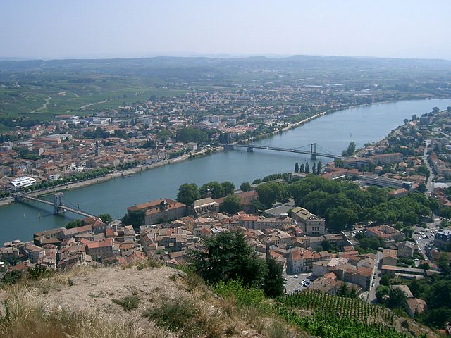
Турнон-сюр-Рон
- коммуна во Франции
Hiking in Турнон-сюр-Рон
Tournon-sur-Rhône, located in the Auvergne-Rhône-Alpes region of France, is an excellent starting point for hikers interested in exploring the stunning landscapes of the Rhône Valley and the surrounding area. Here’s a guide to hiking in this picturesque town and its surroundings:...
- Страна:
- Почтовый код: 07300
- Координаты: 45° 4' 2" N, 4° 49' 58" E
- GPS треки (wikiloc): [Ссылка]
- Высота над уровнем моря: 123 м m
- Площадь: 21.01 кв.км
- Население: 10326
- Веб сайт: [Ссылка]

Мов
- коммуна во Франции
Hiking in Мов
Mauves is a picturesque village located in the Rhône-Alpes region of France, surrounded by stunning landscapes and natural beauty, making it a great destination for hiking enthusiasts. Here are some highlights of hiking in and around Mauves:...
- Страна:
- Почтовый код: 07300
- Координаты: 45° 2' 18" N, 4° 49' 46" E
- GPS треки (wikiloc): [Ссылка]
- Площадь: 7.05 кв.км
- Население: 1171

Лан
- коммуна - Рона — Альпы, Ардеш, Турнон-сюр-Рон
- Страна:
- Почтовый код: 07300
- Координаты: 45° 6' 33" N, 4° 45' 53" E
- GPS треки (wikiloc): [Ссылка]
- Площадь: 12.18 кв.км
- Население: 793


Озон
- Страна:
- Почтовый код: 07370
- Координаты: 45° 9' 57" N, 4° 48' 10" E
- GPS треки (wikiloc): [Ссылка]
- Площадь: 8.32 кв.км
- Население: 403

Вьон
- Страна:
- Почтовый код: 07610
- Координаты: 45° 6' 37" N, 4° 48' 24" E
- GPS треки (wikiloc): [Ссылка]
- Площадь: 6.21 кв.км
- Население: 939

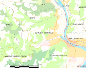
Сен-Жан-де-Мюзоль
- коммуна во Франции
- Страна:
- Почтовый код: 07300
- Координаты: 45° 4' 54" N, 4° 48' 50" E
- GPS треки (wikiloc): [Ссылка]
- Площадь: 10.68 кв.км
- Население: 2391

Сарра
- коммуна во Франции
- Страна:
- Почтовый код: 07370
- Координаты: 45° 11' 13" N, 4° 47' 54" E
- GPS треки (wikiloc): [Ссылка]
- Площадь: 11.65 кв.км
- Население: 2107
- Веб сайт: [Ссылка]