
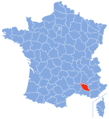
Ардеш (Ardèche, Ardèche)


- департамент Франции
 Hiking in Ардеш
Hiking in the Ardèche region of France offers a remarkable experience for outdoor enthusiasts, with diverse landscapes ranging from dramatic gorges to tranquil forests. Here are some key aspects to consider when hiking in Ardèche:
1.
- Gorges de l'Ardèche: This is one of the most iconic hiking areas, featuring stunning views, unique rock formations, and the famous Pont d'Arc.
- Sentier des Gorges: A popular route along the river, offering breathtaking views and access to swimming spots.
- Mont Gerbier-de-Jonc: Known for its volcanic landscape, this area offers challenging trails with rewarding panoramas.
2.
- The Ardèche region is rich in biodiversity. Hikers may encounter various species of birds, butterflies, and native plants, particularly in the the regional natural parks like Parc Naturel Régional des Monts d'Ardèche.
3.
- Trails in Ardèche cater to all levels, from easy walks suitable for families to challenging treks for experienced hikers. Always check the trail markers and maps, as some paths can be steep or rocky.
4.
- Many trails pass through charming villages and historical sites. Look out for ancient ruins, traditional stone houses, and local markets that reflect the region's rich history.
5.
- Spring (April to June) and autumn (September to October) are ideal for hiking, with mild temperatures and fewer tourists. Summer can be quite hot, so plan for early starts or late afternoon hikes.
6.
- Gear: Ensure you have appropriate footwear, water, and sun protection, especially during warm months.
- Maps and Guides: It’s advisable to carry a map or use a hiking app, as some areas may not have good mobile reception.
- Safety: Always inform someone about your hiking plans, and consider the local wildlife and weather conditions.
7.
- Be respectful of nature and follow local regulations regarding wildlife, vegetation, and campsite practices. Some areas may have restrictions to protect the environment.
Summary
Hiking in the Ardèche combines natural beauty with cultural richness, making it a must-visit destination for those who enjoy the outdoors. Whether you're seeking solitude in the wilderness or social experiences in quaint villages, Ardèche has something to offer every hiker.
- Страна:

- Столица: Прива
- Координаты: 44° 40' 0" N, 4° 25' 0" E


- GPS треки (wikiloc): [Ссылка]
- Площадь: 5529 кв.км
- Население: 324209
- Веб сайт: http://www.ardeche.pref.gouv.fr/
- Википедия русская: wiki(ru)
- Википедия английская: wiki(en)
- Википедия национальная: wiki(fr)
- Хранилище Wikidata: Wikidata: Q3148
- Галерея изображений в википедии: [Ссылка]
- Катеория в википедии: [Ссылка]
- Карты в википедии: [Ссылка]
- код Freebase: [/m/0mgvr]
- код GeoNames: Альт: [3037147]
- номер SIREN: [220700017]
- код BNF: [11862277j]
- код VIAF: Альт: [149812508]
- ID отношения в OpenStreetMap: [7430]
- код GND: Альт: [4079817-3]
- идентификатор местоположения ArchINFORM: [228]
- код тезауруса PACTOLS: [pcrtJlOy6OeKRi]
- место в MusicBrainz: [c541e0a5-3352-48e0-84dc-58ca9fc1bcfc]
- код SUDOC: [026359472]
- код в Большой каталанской энциклопедии: [0004899]
- код ISNI: Альт: [0000 0001 1527 2111]
- dmoz: Альт: [Regional/Europe/France/Regions/Rhone-Alpes/Ardeche/]
- код NLI: [000981359]
- код NUTS: [FR712]
- код департамента Франции INSEE: [07]
- ISO 3166-2: FR-07
Включает регионы:

Монреаль
- коммуна во Франции
- Страна:
- Почтовый код: 07110
- Координаты: 44° 31' 43" N, 4° 17' 34" E
- GPS треки (wikiloc): [Ссылка]
- Площадь: 6.15 кв.км
- Население: 574


Ларжантьер
- округ Франции
- Страна:
- Столица: Ларжантьер
- Координаты: 44° 35' 0" N, 4° 10' 0" E
- GPS треки (wikiloc): [Ссылка]
- Население: 101208


Прива (округ)
Hiking in Прива (округ)
The Arrondissement of Privas, located in the Ardèche department of France, offers a variety of hiking opportunities that cater to different skill levels and preferences. The region is characterized by its stunning landscapes, including rolling hills, rocky gorges, and lush valleys, making it an attractive destination for outdoor enthusiasts....
- Страна:
- Столица: Прива
- Координаты: 44° 38' 17" N, 4° 36' 49" E
- GPS треки (wikiloc): [Ссылка]
- Население: 84795


Турнон-сюр-Рон (округ)
Hiking in Турнон-сюр-Рон (округ)
The Arrondissement of Tournon-sur-Rhône, located in the Auvergne-Rhône-Alpes region of southeastern France, offers some fantastic hiking opportunities, showcasing the beautiful landscapes of the Rhone Valley, vineyards, and the surrounding mountains....
- Страна:
- Столица: Турнон-сюр-Рон
- Координаты: 45° 5' 0" N, 4° 35' 0" E
- GPS треки (wikiloc): [Ссылка]
- Площадь: 1858 кв.км
- Население: 138206
Граничит с регионами:


Гар
- департамент Франции
- Страна:
- Столица: Ним
- Координаты: 44° 7' 41" N, 4° 4' 54" E
- GPS треки (wikiloc): [Ссылка]
- Площадь: 5853 кв.км
- Население: 738189
- Веб сайт: [Ссылка]


Изер
- департамент Франции
Hiking in Изер
Isère, located in the Auvergne-Rhône-Alpes region of France, offers some of the most beautiful and diverse hiking opportunities in the French Alps. Known for its stunning mountain scenery, charming villages, and rich cultural heritage, Isère is a fantastic destination for hikers of all levels. Here are some highlights of hiking in Isère:...
- Страна:
- Столица: Гренобль
- Координаты: 45° 20' 0" N, 5° 30' 0" E
- GPS треки (wikiloc): [Ссылка]
- Высота над уровнем моря: 846 м m
- Площадь: 7431 кв.км
- Население: 1251060
- Веб сайт: [Ссылка]


Луара
- департамент Франции
- Страна:
- Столица: Сент-Этьен
- Координаты: 45° 45' 14" N, 4° 13' 29" E
- GPS треки (wikiloc): [Ссылка]
- Площадь: 4781 кв.км
- Население: 759411
- Веб сайт: [Ссылка]


Верхняя Луара
- департамент Франции
- Страна:
- Столица: Ле-Пюи-ан-Веле
- Координаты: 45° 0' 0" N, 4° 0' 0" E
- GPS треки (wikiloc): [Ссылка]
- Площадь: 4977 кв.км
- Население: 227034
- Веб сайт: [Ссылка]


Лозер
- департамент Франции
- Страна:
- Столица: Манд
- Координаты: 44° 20' 0" N, 3° 36' 0" E
- GPS треки (wikiloc): [Ссылка]
- Площадь: 5166.9 кв.км
- Население: 76309
- Веб сайт: [Ссылка]
Воклюз
- департамент Франции
Hiking in Воклюз
Vaucluse, located in the Provence-Alpes-Côte d'Azur region of southeastern France, offers a diverse range of hiking opportunities, combining stunning landscapes, historical sites, and charming villages. Here are some highlights for hiking in Vaucluse:...
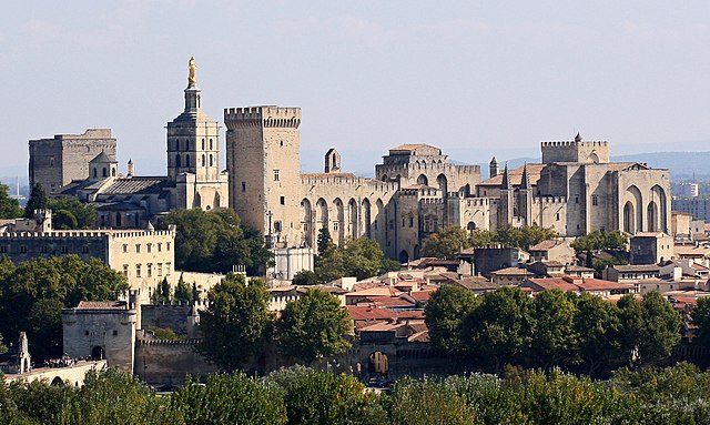
- Страна:
- Столица: Авиньон
- Код автомобильного номера: 84
- Координаты: 44° 0' 0" N, 5° 10' 0" E
- GPS треки (wikiloc): [Ссылка]
- Площадь: 3567 кв.км
- Население: 557548
- Веб сайт: [Ссылка]


Дром
- департамент во Франции
Hiking in Дром
Hiking in the Drôme department in southeastern France is a fantastic experience, known for its diverse landscapes, charming villages, and rich natural heritage. The area offers a variety of trails suitable for all levels of hikers, from beginners to advanced....
- Страна:
- Столица: Валанс
- Координаты: 44° 45' 0" N, 5° 10' 0" E
- GPS треки (wikiloc): [Ссылка]
- Площадь: 6530 кв.км
- Население: 504637
- Веб сайт: [Ссылка]