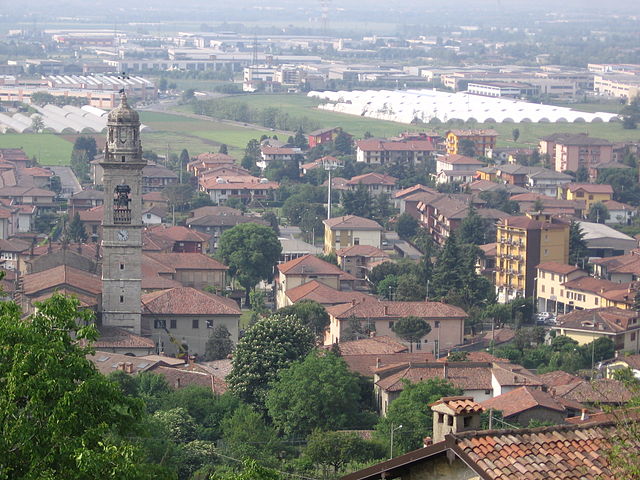
Кароббьо-дельи-Анджели (Carobbio degli Angeli, Carobbio degli Angeli)
.svg)
- коммуна Италии
 Hiking in Кароббьо-дельи-Анджели
Carobbio degli Angeli is a quaint municipality located in the province of Bergamo, in the Lombardy region of Italy. While it may not be as well-known for hiking as other areas in Italy, it offers some beautiful natural surroundings and trails that can appeal to outdoor enthusiasts.
Hiking Highlights in Carobbio degli Angeli:
-
Scenic Trails: The area is characterized by rolling hills, picturesque vineyards, and farmland. You can find various walking paths that allow you to appreciate the serene landscape while enjoying the fresh air.
-
Proximity to Natural Parks: Carobbio is close to the larger natural areas and parks in the Bergamo region, such as the Bergamo Alps. This region offers a wealth of trails for varying skill levels, which you can access for a more extensive hiking experience.
-
Cultural Sites: As you hike around Carobbio, you may come across historical sites, including charming churches and local architecture that can enrich your hiking experience.
-
Gastronomic Stops: Given the region's agricultural background, you can plan your hikes to end at local trattorias or wineries where you can savor traditional Lombardy cuisine and wines, enhancing your outdoor adventure with culinary experiences.
-
Accessibility: The area is easily accessible from Bergamo, making it a convenient option for a day hike or a quick escape into nature.
Tips for Hiking in Carobbio degli Angeli:
- Check Trail Maps: Before heading out, check local resources or hiking apps to find the best trails suited for your skill level.
- Bring Water and Snacks: As with any hike, ensure you have enough water and snacks, especially if you’re planning a longer trek.
- Dress Appropriately: Wear comfortable, weather-appropriate clothing and sturdy hiking shoes, as some trails might be uneven.
- Respect Nature: Follow the Leave No Trace principles to keep the environment clean and preserve the beauty of the landscape.
Conclusion
Though Carobbio degli Angeli may not be a prominent hiking destination, it offers a peaceful escape with beautiful scenery and opportunities for mild hiking experiences. If you're in the Bergamo area, consider exploring the local trails for a unique perspective on the Italian countryside!
- Страна:

- Почтовый код: 24060
- Телефонный код: 035
- Код автомобильного номера: BG
- Координаты: 45° 40' 0" N, 9° 50' 0" E


- GPS треки (wikiloc): [Ссылка]
- Высота над уровнем моря: 232 м m
- Площадь: 6.82 кв.км
- Население: 4700
- Веб сайт: http://www.comune.carobbio.bg.it/
- Википедия русская: wiki(ru)
- Википедия английская: wiki(en)
- Википедия национальная: wiki(it)
- Хранилище Wikidata: Wikidata: Q100149
- Галерея изображений в википедии: [Ссылка]
- Катеория в википедии: [Ссылка]
- код Freebase: [/m/0gj95w]
- код GeoNames: Альт: [6542554]
- код VIAF: Альт: [151433039]
- ID отношения в OpenStreetMap: [45633]
- UN/LOCODE: [ITCBX]
- код ISTAT: 016055
- кадастровый код Италии: B801
Граничит с регионами:

Кьюдуно
- коммуна Италии
Hiking in Кьюдуно
Chiuduno is a small town in the province of Bergamo in Lombardy, Italy. Surrounded by beautiful landscapes and located near the foothills of the Alps, it offers a variety of hiking opportunities for all levels of hikers. Here are some highlights and tips for hiking in and around Chiuduno:...
- Страна:
- Почтовый код: 24060
- Телефонный код: 035
- Код автомобильного номера: BG
- Координаты: 45° 39' 0" N, 9° 51' 0" E
- GPS треки (wikiloc): [Ссылка]
- Высота над уровнем моря: 218 м m
- Площадь: 6.88 кв.км
- Население: 6037
- Веб сайт: [Ссылка]


Гандоссо
- коммуна Италии
Hiking in Гандоссо
Gandosso is a charming village located in the province of Bergamo, in the Lombardy region of Italy. The area is known for its beautiful landscapes, making it a great destination for hiking enthusiasts....
- Страна:
- Почтовый код: 24060
- Телефонный код: 035
- Код автомобильного номера: BG
- Координаты: 45° 39' 0" N, 9° 54' 0" E
- GPS треки (wikiloc): [Ссылка]
- Высота над уровнем моря: 488 м m
- Площадь: 3.13 кв.км
- Население: 1478
- Веб сайт: [Ссылка]


Горлаго
- коммуна Италии
Hiking in Горлаго
Gorlago is a picturesque town located in the Lombardy region of northern Italy, near the city of Bergamo. The area around Gorlago offers a variety of hiking opportunities that showcase the stunning landscapes of the Italian countryside, including rolling hills, forests, and panoramic views of the surrounding mountains....
- Страна:
- Почтовый код: 24060
- Телефонный код: 035
- Код автомобильного номера: BG
- Координаты: 45° 40' 0" N, 9° 49' 0" E
- GPS треки (wikiloc): [Ссылка]
- Высота над уровнем моря: 233 м m
- Площадь: 5.7 кв.км
- Население: 5188
- Веб сайт: [Ссылка]


Грумелло-дель-Монте
- коммуна Италии
Hiking in Грумелло-дель-Монте
Grumello del Monte, located in Lombardy, Italy, is a great destination for hiking enthusiasts. Nestled between the city of Bergamo and the lush hills, it offers a mix of scenic trails, beautiful landscapes, and a chance to experience the local culture. Here’s what you need to know about hiking in the area:...
- Страна:
- Почтовый код: 24064
- Телефонный код: 035
- Код автомобильного номера: BG
- Координаты: 45° 38' 0" N, 9° 52' 0" E
- GPS треки (wikiloc): [Ссылка]
- Высота над уровнем моря: 208 м m
- Площадь: 9.94 кв.км
- Население: 7427
- Веб сайт: [Ссылка]


Трескоре-Бальнеарио
- коммуна Италии
Hiking in Трескоре-Бальнеарио
Trescore Balneario, located in the province of Bergamo in northern Italy, is a charming town known for its thermal baths and scenic landscapes. While it's not as widely recognized for hiking as some other areas in the Italian Alps, it can serve as a great base for exploring nearby trails and natural attractions....
- Страна:
- Почтовый код: 24069
- Телефонный код: 035
- Код автомобильного номера: BG
- Координаты: 45° 42' 0" N, 9° 51' 0" E
- GPS треки (wikiloc): [Ссылка]
- Высота над уровнем моря: 271 м m
- Площадь: 13.51 кв.км
- Население: 9814
- Веб сайт: [Ссылка]


Больгаре
- коммуна Италии
Hiking in Больгаре
Bolgare is a small town in the province of Bergamo, Lombardy, Italy. Nestled in a beautiful region that offers access to the stunning landscapes of the Italian Alps, Bolgare is a great starting point for various hiking adventures....
- Страна:
- Почтовый код: 24060
- Телефонный код: 035
- Код автомобильного номера: BG
- Координаты: 45° 38' 3" N, 9° 49' 1" E
- GPS треки (wikiloc): [Ссылка]
- Высота над уровнем моря: 199 м m
- Площадь: 8.59 кв.км
- Население: 6183
- Веб сайт: [Ссылка]