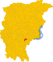
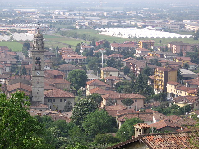
Грумелло-дель-Монте (Grumello del Monte, Grumello del Monte)
.svg)
- коммуна Италии
 Hiking in Грумелло-дель-Монте
Grumello del Monte, located in Lombardy, Italy, is a great destination for hiking enthusiasts. Nestled between the city of Bergamo and the lush hills, it offers a mix of scenic trails, beautiful landscapes, and a chance to experience the local culture. Here’s what you need to know about hiking in the area:
Trails and Routes
-
Sentiero dei Fiori: This trail is known for its beautiful vistas and diverse flora. It’s family-friendly and relatively easy, making it suitable for hikers of all levels.
-
Monte Misma: A moderate hike that leads you to the top of Monte Misma, offering panoramic views of the surrounding countryside. This trail can be more challenging, so prepare accordingly.
-
The Valle Seriana: Explore the trails that lead into the Valle Seriana, where you can experience the region's natural beauty, rivers, and mountains. There are various paths that cater to different skill levels.
-
Ciclovia dei Laghi: For those who enjoy biking as well as hiking, this route links lakes and trails around the area, perfect for a combined adventure.
Scenic Views
From various vantage points, hikers can enjoy stunning views of the surrounding mountains, vineyards, and small villages. The region is also known for its lush greenery in spring and vibrant colors in autumn.
Best Time to Hike
- Spring (April to June): This is an excellent time for hiking as the weather is pleasant, and the wildflowers are in bloom.
- Fall (September to November): Another great season for outdoor activities with mild weather and colorful foliage.
Preparation Tips
- Footwear: Make sure to wear sturdy hiking boots as some trails can be rocky or uneven.
- Water and Snacks: Always carry enough water and some snacks, especially for longer hikes.
- Map and Navigation: Though many trails are marked, it's a good idea to have a map or a hiking app for navigation.
Local Culture and Attractions
After hiking, you can explore Grumello del Monte’s quaint village atmosphere, where you can sample local cuisine, visit historical sites, and enjoy the hospitality of the region.
Safety Precautions
Always inform someone about your hiking plans, check the weather before you set out, and adhere to trail markers to avoid getting lost.
Overall, Grumello del Monte offers a unique and delightful hiking experience that combines the beauty of nature with cultural exploration. Happy hiking!
- Страна:

- Почтовый код: 24064
- Телефонный код: 035
- Код автомобильного номера: BG
- Координаты: 45° 38' 0" N, 9° 52' 0" E


- GPS треки (wikiloc): [Ссылка]
- Высота над уровнем моря: 208 м m
- Площадь: 9.94 кв.км
- Население: 7427
- Веб сайт: http://www.comune.grumellodelmonte.bg.it
- Википедия русская: wiki(ru)
- Википедия английская: wiki(en)
- Википедия национальная: wiki(it)
- Хранилище Wikidata: Wikidata: Q101161
- Галерея изображений в википедии: [Ссылка]
- Катеория в википедии: [Ссылка]
- код Freebase: [/m/0gjbrg]
- код GeoNames: Альт: [6536546]
- код VIAF: Альт: [296724344]
- ID отношения в OpenStreetMap: [45497]
- код TGN: [1044907]
- UN/LOCODE: [ITGMD]
- код ISTAT: 016120
- кадастровый код Италии: E219
Граничит с регионами:

Кароббьо-дельи-Анджели
- коммуна Италии
Hiking in Кароббьо-дельи-Анджели
Carobbio degli Angeli is a quaint municipality located in the province of Bergamo, in the Lombardy region of Italy. While it may not be as well-known for hiking as other areas in Italy, it offers some beautiful natural surroundings and trails that can appeal to outdoor enthusiasts....
- Страна:
- Почтовый код: 24060
- Телефонный код: 035
- Код автомобильного номера: BG
- Координаты: 45° 40' 0" N, 9° 50' 0" E
- GPS треки (wikiloc): [Ссылка]
- Высота над уровнем моря: 232 м m
- Площадь: 6.82 кв.км
- Население: 4700
- Веб сайт: [Ссылка]
Кастелли-Калепьо
- коммуна Италии
Hiking in Кастелли-Калепьо
Castelli Calepio is a charming area located in the province of Bergamo, Northern Italy, known for its beautiful landscapes that blend hills, vineyards, and natural reserves. Hiking in this region offers a great opportunity to experience the stunning scenery and the rich cultural heritage of the area....
- Страна:
- Почтовый код: 24060
- Телефонный код: 035
- Код автомобильного номера: BG
- Координаты: 45° 38' 0" N, 9° 54' 0" E
- GPS треки (wikiloc): [Ссылка]
- Высота над уровнем моря: 259 м m
- Площадь: 10.15 кв.км
- Население: 10453
- Веб сайт: [Ссылка]

Кьюдуно
- коммуна Италии
Hiking in Кьюдуно
Chiuduno is a small town in the province of Bergamo in Lombardy, Italy. Surrounded by beautiful landscapes and located near the foothills of the Alps, it offers a variety of hiking opportunities for all levels of hikers. Here are some highlights and tips for hiking in and around Chiuduno:...
- Страна:
- Почтовый код: 24060
- Телефонный код: 035
- Код автомобильного номера: BG
- Координаты: 45° 39' 0" N, 9° 51' 0" E
- GPS треки (wikiloc): [Ссылка]
- Высота над уровнем моря: 218 м m
- Площадь: 6.88 кв.км
- Население: 6037
- Веб сайт: [Ссылка]


Гандоссо
- коммуна Италии
Hiking in Гандоссо
Gandosso is a charming village located in the province of Bergamo, in the Lombardy region of Italy. The area is known for its beautiful landscapes, making it a great destination for hiking enthusiasts....
- Страна:
- Почтовый код: 24060
- Телефонный код: 035
- Код автомобильного номера: BG
- Координаты: 45° 39' 0" N, 9° 54' 0" E
- GPS треки (wikiloc): [Ссылка]
- Высота над уровнем моря: 488 м m
- Площадь: 3.13 кв.км
- Население: 1478
- Веб сайт: [Ссылка]


Тельгате
- коммуна Италии
Hiking in Тельгате
Telgate is a charming town located in the Lombardy region of Italy, nestled in the hills near Lake Iseo and the Orobian Alps. While it may not be as widely known as some larger hiking destinations, it offers a variety of outdoor activities, including hiking trails that cater to different skill levels....
- Страна:
- Почтовый код: 24060
- Телефонный код: 035
- Код автомобильного номера: BG
- Координаты: 45° 38' 0" N, 9° 51' 0" E
- GPS треки (wikiloc): [Ссылка]
- Высота над уровнем моря: 191 м m
- Площадь: 8.3 кв.км
- Население: 5040
- Веб сайт: [Ссылка]

Палаццоло-сулл'Ольо
- коммуна Италии
Hiking in Палаццоло-сулл'Ольо
Palazzolo sull'Oglio is a charming town in the Lombardy region of Italy, located along the Oglio River. While it may not be as widely recognized as a hiking destination compared to the nearby mountains and lakes, it offers some pleasant walking and hiking opportunities in the surrounding areas. Here are some things to consider for hiking in and around Palazzolo sull'Oglio:...
- Страна:
- Почтовый код: 25036
- Телефонный код: 030
- Код автомобильного номера: BS
- Координаты: 45° 36' 0" N, 9° 53' 0" E
- GPS треки (wikiloc): [Ссылка]
- Высота над уровнем моря: 170 м m
- Площадь: 23.04 кв.км
- Население: 20026
- Веб сайт: [Ссылка]