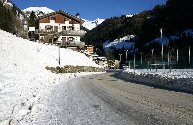
Карона (Carona, Lombardy, Carona)
.svg)
- коммуна Италии
 Hiking in Карона
Carona, located in the beautiful Lombardy region of Italy, is a fantastic destination for hiking enthusiasts. Nestled in the Bergamo Alps, Carona offers a range of trails suitable for various skill levels, marked by stunning landscapes, lush forests, and picturesque views of the surrounding mountains and valleys.
Key Hiking Trails in Carona
-
Sentiero degli alpeggi:
- This trail takes you through ancient alpine pastures, and you'll get to experience the region's traditional agricultural practices. The path is moderately challenging, suitable for hikers who enjoy a mix of nature and cultural history.
-
Sanctuario della Madonna della Cinta:
- A relatively easy hike leads you to this beautiful sanctuary, with charming views along the way. It's a great option for families or those looking for a less strenuous outing.
-
Laghi Gemelli (Twin Lakes):
- More suited for experienced hikers, this trail leads to the breathtaking Twin Lakes, surrounded by stunning mountain scenery. The hike can be challenging but rewards with spectacular views of the lakes and the high-altitude environment.
-
Monte Grem:
- This hike is fairly demanding but offers excellent panoramic views of the Bergamo Alps. The trail ascends to the summit, where you can enjoy vistas that stretch for miles on a clear day.
Practical Tips
-
Best Time to Hike: Spring to early fall (April to October) is the best time for hiking in Carona when the weather is generally favorable, and the trails are well-maintained.
-
Equipment: Proper hiking boots, weather-appropriate clothing, and plenty of water are essential. A map or GPS device can be handy for navigating the trails.
-
Local Wildlife: Keep an eye out for local wildlife, including deer and various bird species. Respect their habitat and maintain a safe distance.
-
Safety: Check weather conditions before heading out, and inform someone about your hiking plans for safety.
-
Accommodation and Amenities: Carona has various accommodation options, including guesthouses and hotels. Local eateries offer delicious Lombard cuisine, which is perfect for replenishing energy after a day of hiking.
Hiking in Carona provides a memorable experience, combining physical activity with the opportunity to appreciate the stunning natural beauty of the Italian Alps. Enjoy your hiking adventure!
- Страна:

- Почтовый код: 24010
- Телефонный код: 0345
- Код автомобильного номера: BG
- Координаты: 46° 1' 20" N, 9° 47' 2" E


- GPS треки (wikiloc): [Ссылка]
- Высота над уровнем моря: 1110 м m
- Площадь: 44.15 кв.км
- Население: 313
- Веб сайт: http://www.comune.carona.bg.it
- Википедия русская: wiki(ru)
- Википедия английская: wiki(en)
- Википедия национальная: wiki(it)
- Хранилище Wikidata: Wikidata: Q100151
- Галерея изображений в википедии: [Ссылка]
- Катеория в википедии: [Ссылка]
- код Freebase: [/m/0gj96l]
- код GeoNames: Альт: [6539621]
- код VIAF: Альт: [228145858168523022398]
- ID отношения в OpenStreetMap: [46712]
- код ISTAT: 016056
- кадастровый код Италии: B803
- LombardiaBeniCulturali toponym ID: 1000122
Граничит с регионами:


Фопполо
- коммуна Италии
Hiking in Фопполо
Foppolo, located in the Italian Alps in the Lombardy region, is a popular destination for hiking enthusiasts. Known for its stunning mountain scenery, lush valleys, and crystal-clear streams, Foppolo offers a variety of trails suitable for both novice and experienced hikers....
- Страна:
- Почтовый код: 24010
- Телефонный код: 0345
- Код автомобильного номера: BG
- Координаты: 46° 2' 34" N, 9° 45' 31" E
- GPS треки (wikiloc): [Ссылка]
- Высота над уровнем моря: 1615 м m
- Площадь: 16.14 кв.км
- Население: 185
- Веб сайт: [Ссылка]


Ганделлино
- коммуна Италии
Hiking in Ганделлино
Gandellino is a charming village located within the scenic Bergamo province in the northern part of Italy, specifically in the Lombardy region. It is situated in the impressive Val Seriana, known for its breathtaking landscapes, alpine scenery, and diverse hiking trails....
- Страна:
- Почтовый код: 24020
- Телефонный код: 0346
- Код автомобильного номера: BG
- Координаты: 45° 59' 24" N, 9° 56' 47" E
- GPS треки (wikiloc): [Ссылка]
- Высота над уровнем моря: 675 м m
- Площадь: 25.13 кв.км
- Население: 991
- Веб сайт: [Ссылка]


Вальбондионе
- коммуна Италии
Hiking in Вальбондионе
Valbondione is a stunning valley located in the Bergamo Alps of northern Italy, offering a wealth of hiking opportunities for all levels of outdoor enthusiasts. Here are some key highlights and practical tips for hiking in this beautiful area:...
- Страна:
- Почтовый код: 24020
- Телефонный код: 0346
- Код автомобильного номера: BG
- Координаты: 46° 2' 16" N, 10° 0' 47" E
- GPS треки (wikiloc): [Ссылка]
- Высота над уровнем моря: 900 м m
- Площадь: 96.89 кв.км
- Население: 1051
- Веб сайт: [Ссылка]


Вальгольо
- коммуна Италии
Hiking in Вальгольо
Valgoglio is a picturesque area located in the province of Bergamo, Lombardy, Italy, known for its stunning natural landscapes and rich hiking opportunities. The region is characterized by its rugged mountains, lush forests, and tranquil valleys, making it an excellent destination for outdoor enthusiasts and hikers of all skill levels....
- Страна:
- Почтовый код: 24020
- Телефонный код: 0346
- Код автомобильного номера: BG
- Координаты: 45° 58' 0" N, 9° 55' 0" E
- GPS треки (wikiloc): [Ссылка]
- Высота над уровнем моря: 929 м m
- Площадь: 31.89 кв.км
- Население: 596
- Веб сайт: [Ссылка]

Валлеве
- коммуна Италии
Hiking in Валлеве
Valleve, located in the Bergamo province of Italy, offers stunning landscapes and a variety of hiking opportunities for all levels of outdoor enthusiasts. Nestled in the Italian Alps, Valleve is characterized by its picturesque valleys, lush forests, and breathtaking mountain views....
- Страна:
- Почтовый код: 24010
- Телефонный код: 0345
- Код автомобильного номера: BG
- Координаты: 46° 2' 0" N, 9° 45' 0" E
- GPS треки (wikiloc): [Ссылка]
- Высота над уровнем моря: 1141 м m
- Площадь: 14.76 кв.км
- Население: 133
- Веб сайт: [Ссылка]
Кайоло
- коммуна Италии
Hiking in Кайоло
Caiolo is a charming village located in the Valtellina valley in northern Italy, known for its beautiful landscapes and rich outdoor activities, including hiking. Here are some highlights and tips for hiking in and around Caiolo:...
- Страна:
- Почтовый код: 23010
- Телефонный код: 0342
- Код автомобильного номера: SO
- Координаты: 46° 9' 0" N, 9° 48' 0" E
- GPS треки (wikiloc): [Ссылка]
- Высота над уровнем моря: 335 м m
- Площадь: 32.97 кв.км
- Население: 1085
- Веб сайт: [Ссылка]
Пьятеда
- коммуна Италии
Hiking in Пьятеда
Piateda is a charming village located in the Lombardy region of northern Italy, nestled in the picturesque Valtellina Valley. For hiking enthusiasts, the area offers a variety of trails that cater to different skill levels, allowing you to immerse yourself in stunning Alpine landscapes, lush forests, and panoramic views of the surrounding mountains....
- Страна:
- Почтовый код: 23020
- Телефонный код: 0342
- Код автомобильного номера: SO
- Координаты: 46° 9' 35" N, 9° 56' 6" E
- GPS треки (wikiloc): [Ссылка]
- Высота над уровнем моря: 304 м m
- Площадь: 70.8 кв.км
- Население: 2158
- Веб сайт: [Ссылка]


Бранци
- коммуна Италии
Hiking in Бранци
Branzi, a picturesque village located in the Italian Alps, is a fantastic destination for hiking enthusiasts. Situated in the Valle Brembana in Lombardy, it offers stunning landscapes, diverse trails, and a rich natural environment. Here are some highlights of hiking in Branzi:...
- Страна:
- Почтовый код: 24010
- Телефонный код: 0345
- Код автомобильного номера: BG
- Координаты: 46° 0' 0" N, 9° 46' 0" E
- GPS треки (wikiloc): [Ссылка]
- Высота над уровнем моря: 874 м m
- Площадь: 26.19 кв.км
- Население: 712
- Веб сайт: [Ссылка]