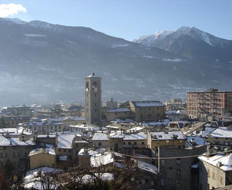
Кайоло (Caiolo, Caiolo)
.svg)
- коммуна Италии
 Hiking in Кайоло
Caiolo is a charming village located in the Valtellina valley in northern Italy, known for its beautiful landscapes and rich outdoor activities, including hiking. Here are some highlights and tips for hiking in and around Caiolo:
Trail Highlights:
-
Valtellina Trails: Caiolo is connected to a network of hiking trails that offer stunning views of the surrounding mountains and valleys. The area features both easy walks and more challenging hikes for various skill levels.
-
Monte Masuccio: One of the notable hikes is to Monte Masuccio, which provides panoramic views of the Valtellina valley. The trail can be steep, so be sure to wear appropriate footwear and bring plenty of water.
-
Caiolo to Dazio: A popular route is the hike from Caiolo to the nearby village of Dazio. This trail is relatively easy and offers scenic views, making it suitable for families and beginners.
-
Cinghiale Path: There's a beautiful trail called the Cinghiale Path that runs through the woods and showcases local flora and fauna. It’s an excellent option for nature lovers and photographers.
Practical Tips:
-
Weather: Check the weather conditions before heading out, as they can change rapidly in the mountains. Dress in layers and be prepared for cooler temperatures at higher elevations.
-
Trail Maps: It’s advisable to have a detailed trail map or a hiking app for navigation, as signage can vary.
-
Water and Snacks: Always carry enough water and snacks to keep your energy levels up, especially on longer hikes.
-
Leave No Trace: Keep the natural environment pristine by following Leave No Trace principles. Always pack out what you pack in.
-
Local Guides: If you're unfamiliar with the area or want a deeper understanding of the local ecology and history, consider hiring a local guide.
Best Times to Hike:
- Spring (April to June): Ideal for enjoying blooming wildflowers and moderate temperatures.
- Summer (July to August): Great for long hikes, though it can get quite busy.
- Autumn (September to October): Offers breathtaking fall foliage and cooler weather, making it an excellent time for hiking.
Caiolo's combination of scenic beauty and well-maintained trails makes it an excellent base for hiking enthusiasts exploring the Valtellina region.
- Страна:

- Почтовый код: 23010
- Телефонный код: 0342
- Код автомобильного номера: SO
- Координаты: 46° 9' 0" N, 9° 48' 0" E


- GPS треки (wikiloc): [Ссылка]
- Высота над уровнем моря: 335 м m
- Площадь: 32.97 кв.км
- Население: 1085
- Веб сайт: http://www.comune.caiolo.so.it
- Википедия русская: wiki(ru)
- Википедия английская: wiki(en)
- Википедия национальная: wiki(it)
- Хранилище Wikidata: Wikidata: Q40913
- Катеория в википедии: [Ссылка]
- код Freebase: [/m/0gj2n8]
- код GeoNames: Альт: [6543734]
- код VIAF: Альт: [235244262]
- ID отношения в OpenStreetMap: [46776]
- UN/LOCODE: [ITCO7]
- код ISTAT: 014011
- кадастровый код Италии: B366
Граничит с регионами:


Карона
- коммуна Италии
Hiking in Карона
Carona, located in the beautiful Lombardy region of Italy, is a fantastic destination for hiking enthusiasts. Nestled in the Bergamo Alps, Carona offers a range of trails suitable for various skill levels, marked by stunning landscapes, lush forests, and picturesque views of the surrounding mountains and valleys....
- Страна:
- Почтовый код: 24010
- Телефонный код: 0345
- Код автомобильного номера: BG
- Координаты: 46° 1' 20" N, 9° 47' 2" E
- GPS треки (wikiloc): [Ссылка]
- Высота над уровнем моря: 1110 м m
- Площадь: 44.15 кв.км
- Население: 313
- Веб сайт: [Ссылка]


Фопполо
- коммуна Италии
Hiking in Фопполо
Foppolo, located in the Italian Alps in the Lombardy region, is a popular destination for hiking enthusiasts. Known for its stunning mountain scenery, lush valleys, and crystal-clear streams, Foppolo offers a variety of trails suitable for both novice and experienced hikers....
- Страна:
- Почтовый код: 24010
- Телефонный код: 0345
- Код автомобильного номера: BG
- Координаты: 46° 2' 34" N, 9° 45' 31" E
- GPS треки (wikiloc): [Ссылка]
- Высота над уровнем моря: 1615 м m
- Площадь: 16.14 кв.км
- Население: 185
- Веб сайт: [Ссылка]
Посталезио
- коммуна Италии
Hiking in Посталезио
Postalesio is a charming destination for hikers, located in the Valtellina valley in northern Italy. It's surrounded by the stunning Alps, and offers a range of hiking trails that cater to different skill levels, from gentle walks to more challenging routes....
- Страна:
- Почтовый код: 23010
- Телефонный код: 0342
- Код автомобильного номера: SO
- Координаты: 46° 10' 0" N, 9° 47' 0" E
- GPS треки (wikiloc): [Ссылка]
- Высота над уровнем моря: 516 м m
- Площадь: 10.58 кв.км
- Население: 666
- Веб сайт: [Ссылка]
Чедраско
- коммуна Италии
Hiking in Чедраско
Cedrasco is a small municipality located in the Valtellina valley in the Lombardy region of Italy. It is surrounded by stunning natural scenery, making it a great destination for hiking enthusiasts. Here are some highlights about hiking in and around Cedrasco:...
- Страна:
- Почтовый код: 23010
- Телефонный код: 0342
- Код автомобильного номера: SO
- Координаты: 46° 9' 0" N, 9° 46' 0" E
- GPS треки (wikiloc): [Ссылка]
- Высота над уровнем моря: 287 м m
- Площадь: 14.42 кв.км
- Население: 442
- Веб сайт: [Ссылка]
Альбозагджа
- коммуна Италии
Hiking in Альбозагджа
Albosaggia, located in the Lombardy region of Italy, offers beautiful hiking opportunities with stunning views of the surrounding mountains and valleys. Here are some highlights and tips for hiking in this picturesque area:...
- Страна:
- Почтовый код: 23010
- Телефонный код: 0342
- Код автомобильного номера: SO
- Координаты: 46° 9' 0" N, 9° 51' 0" E
- GPS треки (wikiloc): [Ссылка]
- Высота над уровнем моря: 490 м m
- Площадь: 34.35 кв.км
- Население: 3020
- Веб сайт: [Ссылка]


Кастьоне-Андевенно
- коммуна Италии
Hiking in Кастьоне-Андевенно
Castione Andevenno is a charming village located in the Valtellina valley in the Lombardy region of Italy. It offers several hiking opportunities that appeal to various skill levels, providing breathtaking views of the surrounding mountains and countryside....
- Страна:
- Почтовый код: 23012
- Телефонный код: 0342
- Код автомобильного номера: SO
- Координаты: 46° 10' 0" N, 9° 48' 0" E
- GPS треки (wikiloc): [Ссылка]
- Высота над уровнем моря: 468 м m
- Площадь: 17.03 кв.км
- Население: 1575
- Веб сайт: [Ссылка]
Пьятеда
- коммуна Италии
Hiking in Пьятеда
Piateda is a charming village located in the Lombardy region of northern Italy, nestled in the picturesque Valtellina Valley. For hiking enthusiasts, the area offers a variety of trails that cater to different skill levels, allowing you to immerse yourself in stunning Alpine landscapes, lush forests, and panoramic views of the surrounding mountains....
- Страна:
- Почтовый код: 23020
- Телефонный код: 0342
- Код автомобильного номера: SO
- Координаты: 46° 9' 35" N, 9° 56' 6" E
- GPS треки (wikiloc): [Ссылка]
- Высота над уровнем моря: 304 м m
- Площадь: 70.8 кв.км
- Население: 2158
- Веб сайт: [Ссылка]

Сондрио
- коммуна Италии
Hiking in Сондрио
Sondrio, located in the Lombardy region of northern Italy, offers a variety of stunning hiking opportunities, particularly in the surrounding Valtellina Valley and the adjacent Stelvio National Park. Here are some highlights and essential information for hiking in the Sondrio area:...
- Страна:
- Почтовый код: 23100
- Телефонный код: 0342
- Код автомобильного номера: SO
- Координаты: 46° 10' 11" N, 9° 52' 12" E
- GPS треки (wikiloc): [Ссылка]
- Высота над уровнем моря: 360 м m
- Площадь: 20.88 кв.км
- Население: 21642
- Веб сайт: [Ссылка]