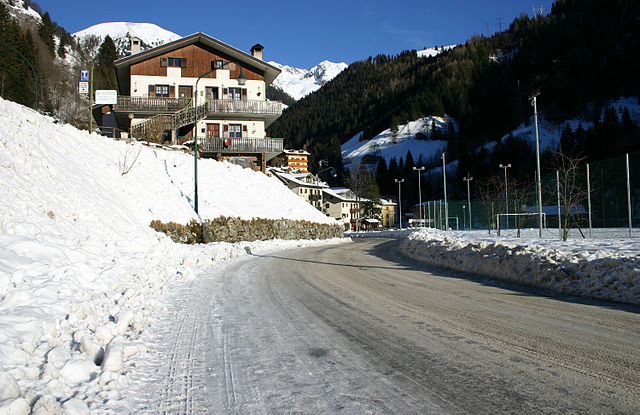
Фопполо (Foppolo, Foppolo)
.svg)
- коммуна Италии
 Hiking in Фопполо
Foppolo, located in the Italian Alps in the Lombardy region, is a popular destination for hiking enthusiasts. Known for its stunning mountain scenery, lush valleys, and crystal-clear streams, Foppolo offers a variety of trails suitable for both novice and experienced hikers.
Hiking Trails
-
Sentiero dei Mirtilli: This relatively easy trail takes you through fragrant blueberry bushes and offers breathtaking views of the surrounding hills and valleys. It's a great option for families and those looking for a leisurely hike.
-
Monte Baradello: A moderate hike that rewards trekkers with panoramic views once they reach the summit. The trail provides a good workout while allowing hikers to immerse themselves in the natural beauty of the area.
-
Valveggi Trail: This more challenging route takes you through dense forests and rugged terrains. As you hike, you can enjoy stunning views of the neighboring peaks and valleys. Ideal for seasoned hikers looking for an adventure.
Wildlife and Scenery
Hiking in Foppolo not only allows you to enjoy beautiful landscapes but also the chance to observe diverse wildlife. You might encounter deer, chamois, and various bird species along the trails. The region is also rich in alpine flora, especially during the spring and summer.
Best Time to Hike
The best time for hiking in Foppolo is from late spring to early autumn (May to September), when the weather is generally stable and trails are more accessible. However, check for local conditions, as snow can linger into early summer on higher altitudes.
Preparations
- Gear: Make sure to wear proper hiking boots and bring layers, as mountain weather can change quickly.
- Water & Snacks: Carry enough water and some energy-packed snacks to keep you fueled during your hike.
- Maps: It’s advisable to have a detailed map or GPS device, particularly if you're exploring more remote trails.
Local Services
Foppolo also has various services for hikers, including guided tours, huts for rest, and accommodation options. Local guides can provide valuable insights into the area’s history and wildlife.
Whether you're looking for a peaceful walk in nature or a rigorous trek, Foppolo has something to offer for every hiking enthusiast. Always prioritize safety, plan ahead, and respect the environment as you explore the beautiful landscapes of the Italian Alps!
- Страна:

- Почтовый код: 24010
- Телефонный код: 0345
- Код автомобильного номера: BG
- Координаты: 46° 2' 34" N, 9° 45' 31" E


- GPS треки (wikiloc): [Ссылка]
- Высота над уровнем моря: 1615 м m
- Площадь: 16.14 кв.км
- Население: 185
- Веб сайт: http://www.comune.foppolo.bg.it
- Википедия русская: wiki(ru)
- Википедия английская: wiki(en)
- Википедия национальная: wiki(it)
- Хранилище Wikidata: Wikidata: Q101067
- Галерея изображений в википедии: [Ссылка]
- Катеория в википедии: [Ссылка]
- код Freebase: [/m/0gjb80]
- код GeoNames: Альт: [6540346]
- код VIAF: Альт: [234764741]
- ID отношения в OpenStreetMap: [46775]
- WOEID: [715638]
- код ISTAT: 016103
- кадастровый код Италии: D688
Граничит с регионами:


Карона
- коммуна Италии
Hiking in Карона
Carona, located in the beautiful Lombardy region of Italy, is a fantastic destination for hiking enthusiasts. Nestled in the Bergamo Alps, Carona offers a range of trails suitable for various skill levels, marked by stunning landscapes, lush forests, and picturesque views of the surrounding mountains and valleys....
- Страна:
- Почтовый код: 24010
- Телефонный код: 0345
- Код автомобильного номера: BG
- Координаты: 46° 1' 20" N, 9° 47' 2" E
- GPS треки (wikiloc): [Ссылка]
- Высота над уровнем моря: 1110 м m
- Площадь: 44.15 кв.км
- Население: 313
- Веб сайт: [Ссылка]

Валлеве
- коммуна Италии
Hiking in Валлеве
Valleve, located in the Bergamo province of Italy, offers stunning landscapes and a variety of hiking opportunities for all levels of outdoor enthusiasts. Nestled in the Italian Alps, Valleve is characterized by its picturesque valleys, lush forests, and breathtaking mountain views....
- Страна:
- Почтовый код: 24010
- Телефонный код: 0345
- Код автомобильного номера: BG
- Координаты: 46° 2' 0" N, 9° 45' 0" E
- GPS треки (wikiloc): [Ссылка]
- Высота над уровнем моря: 1141 м m
- Площадь: 14.76 кв.км
- Население: 133
- Веб сайт: [Ссылка]
Чедраско
- коммуна Италии
Hiking in Чедраско
Cedrasco is a small municipality located in the Valtellina valley in the Lombardy region of Italy. It is surrounded by stunning natural scenery, making it a great destination for hiking enthusiasts. Here are some highlights about hiking in and around Cedrasco:...
- Страна:
- Почтовый код: 23010
- Телефонный код: 0342
- Код автомобильного номера: SO
- Координаты: 46° 9' 0" N, 9° 46' 0" E
- GPS треки (wikiloc): [Ссылка]
- Высота над уровнем моря: 287 м m
- Площадь: 14.42 кв.км
- Население: 442
- Веб сайт: [Ссылка]
Тартано
- коммуна Италии
Hiking in Тартано
Tartano is a mountain area located in the Italian Alps, specifically in the Lombardy region. It offers a range of hiking opportunities for both novice and experienced hikers. The region is known for its breathtaking landscapes, including lush forests, alpine meadows, and stunning panoramic views....
- Страна:
- Почтовый код: 23010
- Телефонный код: 0342
- Код автомобильного номера: SO
- Координаты: 46° 7' 0" N, 9° 41' 0" E
- GPS треки (wikiloc): [Ссылка]
- Высота над уровнем моря: 1210 м m
- Площадь: 47.27 кв.км
- Население: 205
- Веб сайт: [Ссылка]
Фузине
- коммуна Италии
Hiking in Фузине
Fusine, located in the Julian Alps of northeastern Italy, is a stunning destination for hiking enthusiasts. The area is known for its picturesque landscapes, crystal-clear alpine lakes, and diverse flora and fauna. Here are some highlights and tips for hiking in Fusine:...
- Страна:
- Почтовый код: 23010
- Телефонный код: 0342
- Код автомобильного номера: SO
- Координаты: 46° 8' 58" N, 9° 44' 59" E
- GPS треки (wikiloc): [Ссылка]
- Высота над уровнем моря: 285 м m
- Площадь: 37 кв.км
- Население: 575
- Веб сайт: [Ссылка]
Кайоло
- коммуна Италии
Hiking in Кайоло
Caiolo is a charming village located in the Valtellina valley in northern Italy, known for its beautiful landscapes and rich outdoor activities, including hiking. Here are some highlights and tips for hiking in and around Caiolo:...
- Страна:
- Почтовый код: 23010
- Телефонный код: 0342
- Код автомобильного номера: SO
- Координаты: 46° 9' 0" N, 9° 48' 0" E
- GPS треки (wikiloc): [Ссылка]
- Высота над уровнем моря: 335 м m
- Площадь: 32.97 кв.км
- Население: 1085
- Веб сайт: [Ссылка]