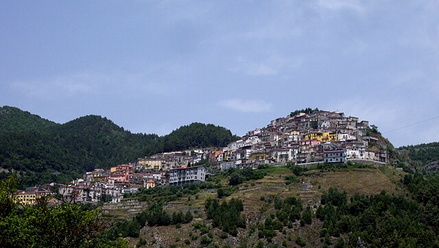
Кастеллуччо-Инфериоре (Castelluccio Inferiore, Castelluccio Inferiore)
.svg)
- коммуна Италии
 Hiking in Кастеллуччо-Инфериоре
Castelluccio Inferiore is a charming village located in the Basilicata region of southern Italy, known for its picturesque landscapes and proximity to the Pollino National Park, which offers a wealth of hiking opportunities. Hikes in and around this area allow you to appreciate the stunning natural beauty, rich biodiversity, and unique geological features.
Hiking Routes:
-
Pollino National Park Trails: The park features numerous trails ranging from easy walks to challenging treks. Some popular ones include:
- Cima Pierno: This trail offers breathtaking views of the surrounding mountains and valleys. The hike can be steep, so proper footwear and preparation are essential.
- Valle del Frido: A more moderate hike that takes you through lush landscapes and offers opportunities for wildlife spotting.
-
Monte Pollino: The highest peak in the park, this hike is more demanding but rewards you with spectacular panoramic views of the surrounding area and its diverse flora and fauna.
-
Caves and Waterfalls: Exploring the various caves and waterfalls around Castelluccio Inferiore can enhance your hiking experience. The area is rich in underground water sources, offering unique geological formations.
Best Times to Hike:
- Spring (March to May): This season is excellent for hiking as temperatures are mild, and the flora is in bloom, creating beautiful landscapes filled with wildflowers.
- Autumn (September to November): Another ideal time for hiking, autumn brings cooler temperatures and vibrant foliage, making for pleasant hiking conditions and stunning views.
Tips for Hiking in Castelluccio Inferiore:
- Prepare Adequately: Check weather conditions before heading out, and dress in layers suitable for changing temperatures. Make sure to bring enough water and snacks.
- Map and Navigation: Carry a physical map or use a GPS device, as cell phone coverage may be limited in remote areas.
- Follow Guidelines: Respect the natural environment by sticking to marked trails and avoiding littering. Local regulations may also dictate certain rules on the trails.
- Safety First: If you’re hiking alone or unfamiliar with the area, consider joining a guided hike or going with a group.
Local Culture:
Beyond the hiking, Castelluccio Inferiore offers a glimpse into local culture with its historical architecture, traditional cuisine, and warm hospitality. Don't miss trying local dishes and enjoying the serene atmosphere of the village after a day of hiking.
Whether you're an experienced hiker or a beginner, Castelluccio Inferiore provides a beautiful backdrop for an outdoor adventure in the heart of Italy's natural landscapes.
- Страна:

- Почтовый код: 85040
- Телефонный код: 0973
- Код автомобильного номера: PZ
- Координаты: 40° 0' 0" N, 15° 59' 0" E


- GPS треки (wikiloc): [Ссылка]
- Высота над уровнем моря: 495 м m
- Площадь: 28.96 кв.км
- Население: 2072
- Веб сайт: http://www.comune.castellucciosuperiore.pz.it
- Википедия русская: wiki(ru)
- Википедия английская: wiki(en)
- Википедия национальная: wiki(it)
- Хранилище Wikidata: Wikidata: Q52552
- Катеория в википедии: [Ссылка]
- код Freebase: [/m/0fh336]
- код GeoNames: Альт: [6541272]
- ID отношения в OpenStreetMap: [40196]
- код ISTAT: 076022
- кадастровый код Италии: C199
Граничит с регионами:

Кастеллуччо-Супериоре
- коммуна Италии
Hiking in Кастеллуччо-Супериоре
Castelluccio Superiore, located in the Basilicata region of southern Italy, is a charming destination for hikers and nature enthusiasts. This picturesque village offers stunning landscapes, rich biodiversity, and a network of trails that showcase the beauty of the surrounding Apennine Mountains....
- Страна:
- Почтовый код: 85040
- Телефонный код: 0973
- Код автомобильного номера: PZ
- Координаты: 40° 1' 0" N, 15° 59' 0" E
- GPS треки (wikiloc): [Ссылка]
- Высота над уровнем моря: 680 м m
- Площадь: 32.98 кв.км
- Население: 796
- Веб сайт: [Ссылка]
Фарделла
- коммуна Италии
Hiking in Фарделла
Fardella is a small village in the Basilicata region of Italy, known for its picturesque landscapes and natural beauty, making it an ideal spot for hiking enthusiasts. Here are some key highlights and tips for hiking in and around Fardella:...
- Страна:
- Почтовый код: 85030
- Телефонный код: 0973
- Код автомобильного номера: PZ
- Координаты: 40° 7' 0" N, 16° 10' 0" E
- GPS треки (wikiloc): [Ссылка]
- Высота над уровнем моря: 745 м m
- Площадь: 29.08 кв.км
- Население: 631
- Веб сайт: [Ссылка]


Латронико
- коммуна Италии
Hiking in Латронико
Latronico, a picturesque town in the southern Italian region of Basilicata, is an excellent destination for hiking enthusiasts. Nestled in the Pollino National Park, Latronico offers a mix of natural beauty, historical sites, and varying terrain suitable for different levels of hiking experience. Here are some key points to consider for hiking in this area:...
- Страна:
- Почтовый код: 85043
- Телефонный код: 0973
- Код автомобильного номера: PZ
- Координаты: 40° 5' 0" N, 16° 1' 0" E
- GPS треки (wikiloc): [Ссылка]
- Высота над уровнем моря: 888 м m
- Площадь: 76.66 кв.км
- Население: 4420
- Веб сайт: [Ссылка]


Лаурия
- коммуна Италии
Hiking in Лаурия
Lauria is a beautiful location in the Basilicata region of southern Italy, known for its stunning landscapes, rich history, and outdoor activities, including hiking. The area offers a variety of trails suitable for different skill levels, from easy walks to more challenging hikes, all set against the backdrop of the Apennine mountains....
- Страна:
- Почтовый код: 85044
- Телефонный код: 0973
- Код автомобильного номера: PZ
- Координаты: 40° 2' 50" N, 15° 50' 9" E
- GPS треки (wikiloc): [Ссылка]
- Высота над уровнем моря: 430 м m
- Площадь: 176.63 кв.км
- Население: 12694
- Веб сайт: [Ссылка]


Ротонда
- коммуна Италии
Hiking in Ротонда
Rotonda, located in the Basilicata region of southern Italy, is a hidden gem for hiking enthusiasts. Surrounded by the Pollino National Park, the area offers stunning natural landscapes, diverse flora and fauna, and a range of hiking trails suitable for various skill levels....
- Страна:
- Почтовый код: 85048
- Телефонный код: 0973
- Код автомобильного номера: PZ
- Координаты: 39° 57' 15" N, 16° 2' 23" E
- GPS треки (wikiloc): [Ссылка]
- Высота над уровнем моря: 635 м m
- Площадь: 42.92 кв.км
- Население: 3435
- Веб сайт: [Ссылка]
Виджанелло
- коммуна Италии
Hiking in Виджанелло
Viggianello is a charming village located in the heart of the Pollino National Park in Calabria, southern Italy. It offers a wonderful mix of natural beauty, cultural heritage, and outdoor activities, making it a great destination for hiking enthusiasts....
- Страна:
- Почтовый код: 85040
- Телефонный код: 0973
- Код автомобильного номера: PZ
- Координаты: 39° 58' 0" N, 16° 5' 0" E
- GPS треки (wikiloc): [Ссылка]
- Высота над уровнем моря: 549 м m
- Площадь: 120.83 кв.км
- Население: 2940
- Веб сайт: [Ссылка]
Лайно-Борго
- коммуна Италии
Hiking in Лайно-Борго
Laino Borgo, located in the Calabria region of southern Italy, is a hidden gem for hiking enthusiasts. Nestled in the Pollino National Park, the area boasts stunning landscapes, diverse wildlife, and impressive geological formations. Here are some highlights and tips for hiking in Laino Borgo:...
- Страна:
- Почтовый код: 87014
- Телефонный код: 0981
- Код автомобильного номера: CS
- Координаты: 39° 57' 0" N, 15° 58' 0" E
- GPS треки (wikiloc): [Ссылка]
- Высота над уровнем моря: 271 м m
- Площадь: 57.08 кв.км
- Население: 1879
- Веб сайт: [Ссылка]