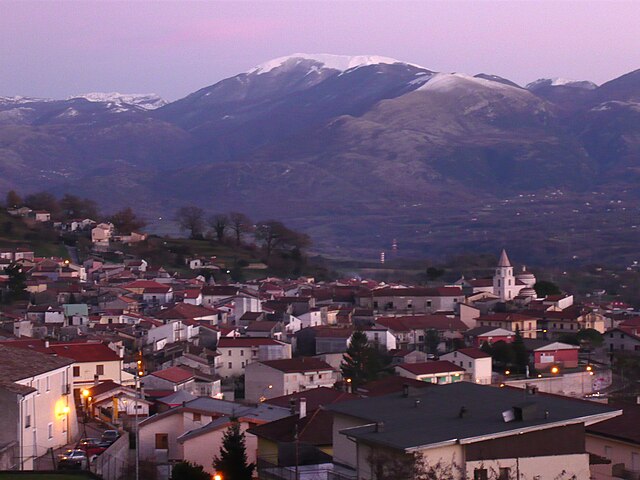
Лаурия (Lauria, Lauria)
.svg)
- коммуна Италии
 Hiking in Лаурия
Lauria is a beautiful location in the Basilicata region of southern Italy, known for its stunning landscapes, rich history, and outdoor activities, including hiking. The area offers a variety of trails suitable for different skill levels, from easy walks to more challenging hikes, all set against the backdrop of the Apennine mountains.
Hiking Opportunities:
-
Scenic Trails: The trails around Lauria often lead through lush forests, past rolling hills, and offer breathtaking views of the surrounding valleys and mountains. You can expect to see a mix of flora and fauna, with opportunities to experience local wildlife.
-
Historical Sites: Many hiking paths may take you near historical landmarks and ruins, such as ancient churches and forts. Exploring these sites can add a cultural element to your outdoor experience.
-
Wildlife Watching: The region is home to a variety of wildlife and bird species, making it an excellent destination for nature enthusiasts.
-
Trails for All Levels: Whether you're a novice hiker or an experienced trekker, Lauria has options for everyone. Check local resources for maps and difficulty ratings to find a hike that suits your comfort level.
Tips for Hiking in Lauria:
-
Weather: Be sure to check the weather before you go. Southern Italy can see varied weather conditions, especially at higher altitudes.
-
Gear: Wear appropriate hiking shoes with good grip and bring layers of clothing to adapt to temperature changes during your hike.
-
Hydration and Snacking: Always carry enough water and some snacks to keep your energy up during the hike.
-
Local Guidance: Consider hiring a local guide for a more enriching experience. They can provide insight into the area’s history, ecology, and the best trails.
-
Respect Nature: Follow Leave No Trace principles to protect the beautiful landscapes and wildlife.
Popular Hiking Trails:
While specific trail names and conditions can change, look for information from local tourist offices or hiking associations about popular trails near Lauria.
In summary, hiking in Lauria presents an opportunity to explore the natural beauty of southern Italy, combined with its rich history. Whether you're seeking a peaceful nature walk or a challenging trek, Lauria has something to offer every adventurer. Enjoy your hike!
- Страна:

- Почтовый код: 85044
- Телефонный код: 0973
- Код автомобильного номера: PZ
- Координаты: 40° 2' 50" N, 15° 50' 9" E


- GPS треки (wikiloc): [Ссылка]
- Высота над уровнем моря: 430 м m
- Площадь: 176.63 кв.км
- Население: 12694
- Веб сайт: http://www.comune.lauria.pz.it/
- Википедия русская: wiki(ru)
- Википедия английская: wiki(en)
- Википедия национальная: wiki(it)
- Хранилище Wikidata: Wikidata: Q52590
- Катеория в википедии: [Ссылка]
- код Freebase: [/m/0bfhg0]
- код GeoNames: Альт: [6540775]
- код VIAF: Альт: [246945329]
- ID отношения в OpenStreetMap: [40203]
- место в MusicBrainz: [54ae9457-48cc-4eab-883c-8a38ca6c4367]
- код ISTAT: 076042
- кадастровый код Италии: E483
Граничит с регионами:

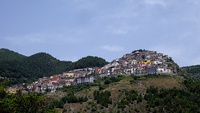
Кастеллуччо-Инфериоре
- коммуна Италии
Hiking in Кастеллуччо-Инфериоре
Castelluccio Inferiore is a charming village located in the Basilicata region of southern Italy, known for its picturesque landscapes and proximity to the Pollino National Park, which offers a wealth of hiking opportunities. Hikes in and around this area allow you to appreciate the stunning natural beauty, rich biodiversity, and unique geological features....
- Страна:
- Почтовый код: 85040
- Телефонный код: 0973
- Код автомобильного номера: PZ
- Координаты: 40° 0' 0" N, 15° 59' 0" E
- GPS треки (wikiloc): [Ссылка]
- Высота над уровнем моря: 495 м m
- Площадь: 28.96 кв.км
- Население: 2072
- Веб сайт: [Ссылка]

Кастеллуччо-Супериоре
- коммуна Италии
Hiking in Кастеллуччо-Супериоре
Castelluccio Superiore, located in the Basilicata region of southern Italy, is a charming destination for hikers and nature enthusiasts. This picturesque village offers stunning landscapes, rich biodiversity, and a network of trails that showcase the beauty of the surrounding Apennine Mountains....
- Страна:
- Почтовый код: 85040
- Телефонный код: 0973
- Код автомобильного номера: PZ
- Координаты: 40° 1' 0" N, 15° 59' 0" E
- GPS треки (wikiloc): [Ссылка]
- Высота над уровнем моря: 680 м m
- Площадь: 32.98 кв.км
- Население: 796
- Веб сайт: [Ссылка]
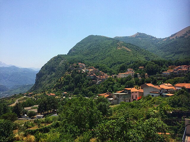
Кастельсарачено
- коммуна Италии
Hiking in Кастельсарачено
Castelsaraceno is a charming village located in the Basilicata region of southern Italy, nestled within the beautiful landscape of the Apennine Mountains. Hiking in and around Castelsaraceno offers a wonderful combination of natural beauty, historical significance, and diverse trails....
- Страна:
- Почтовый код: 85031
- Телефонный код: 0973
- Код автомобильного номера: PZ
- Координаты: 40° 10' 0" N, 15° 59' 0" E
- GPS треки (wikiloc): [Ссылка]
- Высота над уровнем моря: 960 м m
- Площадь: 74.78 кв.км
- Население: 1349
- Веб сайт: [Ссылка]
Лагонегро
- коммуна Италии
Hiking in Лагонегро
Lagonegro is a beautiful town located in the southern Italian region of Basilicata, surrounded by stunning natural landscapes, mountains, and the Pollino National Park. Hiking in Lagonegro offers a variety of trails that cater to different experience levels, making it a fantastic destination for nature lovers and outdoor enthusiasts....
- Страна:
- Почтовый код: 85042
- Телефонный код: 0973
- Код автомобильного номера: PZ
- Координаты: 40° 8' 0" N, 15° 46' 0" E
- GPS треки (wikiloc): [Ссылка]
- Высота над уровнем моря: 666 м m
- Площадь: 113.07 кв.км
- Население: 5442
- Веб сайт: [Ссылка]


Латронико
- коммуна Италии
Hiking in Латронико
Latronico, a picturesque town in the southern Italian region of Basilicata, is an excellent destination for hiking enthusiasts. Nestled in the Pollino National Park, Latronico offers a mix of natural beauty, historical sites, and varying terrain suitable for different levels of hiking experience. Here are some key points to consider for hiking in this area:...
- Страна:
- Почтовый код: 85043
- Телефонный код: 0973
- Код автомобильного номера: PZ
- Координаты: 40° 5' 0" N, 16° 1' 0" E
- GPS треки (wikiloc): [Ссылка]
- Высота над уровнем моря: 888 м m
- Площадь: 76.66 кв.км
- Население: 4420
- Веб сайт: [Ссылка]


Молитерно
- коммуна Италии
Hiking in Молитерно
Moliterno is a small town in the Basilicata region of Southern Italy, nestled in the Appennine mountains. The area around Moliterno is known for its stunning natural landscapes, which provide excellent opportunities for hiking and outdoor activities....
- Страна:
- Почтовый код: 85047
- Телефонный код: 0975
- Код автомобильного номера: PZ
- Координаты: 40° 14' 24" N, 15° 51' 36" E
- GPS треки (wikiloc): [Ссылка]
- Высота над уровнем моря: 879 м m
- Площадь: 98.55 кв.км
- Население: 3916
- Веб сайт: [Ссылка]
Немоли
- коммуна Италии
Hiking in Немоли
Nemoli, located in the Basilicata region of Southern Italy, is a hidden gem for hiking enthusiasts. Nestled in the scenic landscape of the Pollino National Park, it offers stunning natural beauty, diverse wildlife, and a range of hiking trails suitable for various skill levels....
- Страна:
- Почтовый код: 85040
- Телефонный код: 0973
- Код автомобильного номера: PZ
- Координаты: 40° 4' 0" N, 15° 48' 0" E
- GPS треки (wikiloc): [Ссылка]
- Высота над уровнем моря: 421 м m
- Площадь: 19.49 кв.км
- Население: 1471
- Веб сайт: [Ссылка]

Треккина
- коммуна Италии
Hiking in Треккина
Trecchina is a charming town located in the Basilicata region of southern Italy, surrounded by stunning natural landscapes that are ideal for hiking and outdoor activities. Here are some highlights and tips for hiking in and around Trecchina:...
- Страна:
- Почтовый код: 85049
- Телефонный код: 0973
- Код автомобильного номера: PZ
- Координаты: 40° 2' 0" N, 15° 46' 0" E
- GPS треки (wikiloc): [Ссылка]
- Высота над уровнем моря: 500 м m
- Площадь: 38.19 кв.км
- Население: 2297
- Веб сайт: [Ссылка]
Лайно-Борго
- коммуна Италии
Hiking in Лайно-Борго
Laino Borgo, located in the Calabria region of southern Italy, is a hidden gem for hiking enthusiasts. Nestled in the Pollino National Park, the area boasts stunning landscapes, diverse wildlife, and impressive geological formations. Here are some highlights and tips for hiking in Laino Borgo:...
- Страна:
- Почтовый код: 87014
- Телефонный код: 0981
- Код автомобильного номера: CS
- Координаты: 39° 57' 0" N, 15° 58' 0" E
- GPS треки (wikiloc): [Ссылка]
- Высота над уровнем моря: 271 м m
- Площадь: 57.08 кв.км
- Население: 1879
- Веб сайт: [Ссылка]


Тортора
- коммуна Италии
Hiking in Тортора
Hiking in Tortora, a charming town located in the Calabria region of southern Italy, offers a blend of stunning natural landscapes, rich history, and local culture. Here are some highlights for anyone interested in hiking in and around Tortora:...
- Страна:
- Почтовый код: 87020
- Телефонный код: 0985
- Код автомобильного номера: CS
- Координаты: 39° 56' 29" N, 15° 48' 19" E
- GPS треки (wikiloc): [Ссылка]
- Высота над уровнем моря: 312 м m
- Площадь: 58.22 кв.км
- Население: 6163
- Веб сайт: [Ссылка]