Шатлю (Châtelus, Châtelus)

 Hiking in Шатлю
Châtelus is a charming village located in the Isère department of the Auvergne-Rhône-Alpes region in southeastern France. The area is known for its picturesque landscapes, making it a great destination for hiking enthusiasts looking to explore natural beauty and enjoy outdoor activities.
Hiking Trails
-
Scenic Views: The region surrounding Châtelus offers multiple trails that lead to stunning viewpoints, where hikers can enjoy sweeping vistas of the mountains and valleys. Look for marked hiking routes that take you through forests and meadows.
-
Chalet des Cèdres Trail: This is a popular trail that can lead you to the nearby alpine huts, known as chalets, and offers a chance to experience the rich biodiversity of the region.
-
Lac de Monteynard: While not directly in Châtelus, it's a short drive away and offers beautiful hiking opportunities along the shores of the lake, which features stunning turquoise waters and is also popular for water sports.
Tips for Hiking in Châtelus
-
Trail Maps: Make sure to pick up a trail map from the local tourist office or check online resources to ensure you are well-informed about the different hiking routes.
-
Weather Preparedness: The weather in the mountains can change quickly, so always check the forecast before heading out and dress in layers.
-
Essentials: Bring plenty of water, snacks, a first aid kit, and make sure to wear proper hiking shoes.
-
Local Regulations: Respect nature and adhere to local hiking regulations. Stay on marked trails to preserve the environment.
-
Guided Tours: If you're unfamiliar with the area or prefer not to hike alone, consider joining a guided hike to gain insight into the local ecology and history.
Additional Activities
Besides hiking, Châtelus and its surroundings offer opportunities for mountain biking, birdwatching, and exploring local flora and fauna. Enjoying local cuisine in nearby villages can also enhance your outdoor experience.
Overall, Châtelus is a wonderful base for hiking and exploring the beautiful natural landscape of the French Alps!
- Страна:

- Почтовый код: 38680
- Координаты: 45° 3' 29" N, 5° 22' 21" E


- GPS треки (wikiloc): [Ссылка]
- Площадь: 12.3 кв.км
- Население: 96
- Википедия русская: wiki(ru)
- Википедия английская: wiki(en)
- Википедия национальная: wiki(fr)
- Хранилище Wikidata: Wikidata: Q920639
- Катеория в википедии: [Ссылка]
- код Freebase: [/m/03nw6ty]
- код GeoNames: Альт: [6613502]
- номер SIREN: [213800923]
- код BNF: [15257919t]
- код муниципалитета INSEE: 38092
Граничит с регионами:


Saint-Julien-en-Vercors
- коммуна во Франции
Hiking in Saint-Julien-en-Vercors
Saint-Julien-en-Vercors is a beautiful destination in the Vercors Massif of the French Alps, known for its stunning scenery, rich biodiversity, and a variety of hiking trails suitable for all levels. Here are some highlights of hiking in this area:...
- Страна:
- Почтовый код: 26420
- Координаты: 45° 3' 1" N, 5° 26' 58" E
- GPS треки (wikiloc): [Ссылка]
- Площадь: 18.47 кв.км
- Население: 246


Échevis
- коммуна во Франции
Hiking in Échevis
Échevis is a charming village located in the Auvergne-Rhône-Alpes region of France. It's known for its natural beauty, with scenic landscapes that make it an attractive destination for hiking enthusiasts. Here are some key points to consider when hiking in Échevis:...
- Страна:
- Почтовый код: 26190
- Координаты: 45° 1' 38" N, 5° 23' 3" E
- GPS треки (wikiloc): [Ссылка]
- Площадь: 11.11 кв.км
- Население: 49

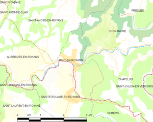
Понт-ан-Руайан
- коммуна во Франции
Hiking in Понт-ан-Руайан
Pont-en-Royans is a charming village located in the Isère department of the Auvergne-Rhône-Alpes region in southeastern France. It is known for its picturesque landscape and stunning cliffs that overlook the river Bourne, making it a fantastic destination for hiking enthusiasts....
- Страна:
- Почтовый код: 38680
- Координаты: 45° 3' 47" N, 5° 20' 34" E
- GPS треки (wikiloc): [Ссылка]
- Площадь: 2.9 кв.км
- Население: 785
- Веб сайт: [Ссылка]

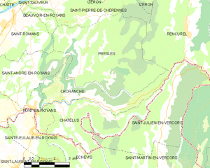
Шоранш
- коммуна во Франции
Hiking in Шоранш
Choranche, located in the Isère department in the Auvergne-Rhône-Alpes region of France, is known for its stunning natural beauty and outdoor activities, including hiking. The area is particularly famous for its impressive gorges, limestone cliffs, and beautiful landscapes....
- Страна:
- Почтовый код: 38680
- Координаты: 45° 4' 1" N, 5° 23' 28" E
- GPS треки (wikiloc): [Ссылка]
- Площадь: 10.63 кв.км
- Население: 124