Chamoux-sur-Gelon (Chamoux-sur-Gelon)

- коммуна во Франции
 Hiking in Chamoux-sur-Gelon
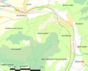
Chamoux-sur-Gelon is a charming village located in the French Alps, specifically in the Savoie region. It offers beautiful hiking opportunities for both beginners and experienced hikers.
Hiking Trails
-
Les Gorges du Gelon: A scenic trail that takes you through impressive gorges and offers stunning views of the surrounding mountains. The trail is relatively moderate and ideal for families.
-
Le Mont Granier: For those looking for a challenge, the hike to Mont Granier is a great option. It has steep sections but rewards hikers with panoramic views from the summit.
-
Col de la Croix de Fer: This is a popular hiking area nearby that can be accessed from Chamoux-sur-Gelon. The route provides spectacular views and diverse landscapes, including alpine meadows and rocky terrain.
Best Times to Hike
The best times to hike in Chamoux-sur-Gelon are late spring to early fall (May to September). During these months, trails are usually clear of snow, and the weather is generally more favorable.
What to Bring
- Hiking Boots: Good footwear is essential, especially on rugged terrain.
- Water and Snacks: Keep hydrated and energized during your hike.
- Map or GPS: Familiarize yourself with the trails. It’s easy to get lost in the expansive wilderness.
- First Aid Kit: Always a good idea for any hike, just in case of minor injuries.
Safety Tips
- Always check weather conditions before heading out.
- Let someone know your hiking plans and estimated return time.
- Be aware of local wildlife and follow guidelines for safety.
Chamoux-sur-Gelon is not just a starting point for beautiful hikes, but also a place to immerse yourself in the natural beauty of the French Alps. Enjoy your adventure!
- Страна:

- Почтовый код: 73390
- Координаты: 45° 31' 58" N, 6° 12' 56" E


- GPS треки (wikiloc): [Ссылка]
- Площадь: 10.63 кв.км
- Население: 924
- Веб сайт: http://Chamoux-sur-Gelon.fr
- Википедия английская: wiki(en)
- Википедия национальная: wiki(fr)
- Хранилище Wikidata: Wikidata: Q1231154
- Катеория в википедии: [Ссылка]
- код Freebase: [/m/03npgr0]
- код GeoNames: Альт: [6450993]
- номер SIREN: [217300698]
- код BNF: [15274003n]
- код муниципалитета INSEE: 73069
Граничит с регионами:
Montendry
- коммуна во Франции
Hiking in Montendry
Montendry, while not as widely known as some other hiking destinations, is a charming area that offers scenery and trails appealing to outdoor enthusiasts. Here are some notable aspects of hiking in Montendry:...
- Страна:
- Почтовый код: 73390
- Координаты: 45° 31' 32" N, 6° 14' 28" E
- GPS треки (wikiloc): [Ссылка]
- Площадь: 8.28 кв.км
- Население: 61

Montgilbert
- коммуна во Франции
Hiking in Montgilbert
Montgilbert is a charming destination located in the Savoie region of the French Alps, known for its stunning landscapes and outdoor activities, including hiking. Here are some key points about hiking in the area:...
- Страна:
- Почтовый код: 73220
- Координаты: 45° 32' 59" N, 6° 17' 5" E
- GPS треки (wikiloc): [Ссылка]
- Площадь: 9.53 кв.км
- Население: 121


Villard-Léger
- коммуна во Франции
Hiking in Villard-Léger
Villard-Léger is a charming commune located in the French Alps, known for its stunning landscapes and extensive outdoor activities, particularly hiking. Here are some highlights about hiking in Villard-Léger:...
- Страна:
- Почтовый код: 73390
- Координаты: 45° 30' 36" N, 6° 10' 44" E
- GPS треки (wikiloc): [Ссылка]
- Площадь: 6.73 кв.км
- Население: 495


Champ-Laurent
- коммуна во Франции
Hiking in Champ-Laurent
Champ-Laurent, located in the French Alps, is a stunning hiking destination that offers a blend of picturesque landscapes, diverse trails, and a rich natural environment. Here are some highlights and tips for hiking in the area:...
- Страна:
- Почтовый код: 73390
- Координаты: 45° 30' 31" N, 6° 12' 44" E
- GPS треки (wikiloc): [Ссылка]
- Площадь: 5.07 кв.км
- Население: 39


Châteauneuf, Savoie
Hiking in Châteauneuf, Savoie
Châteauneuf is a charming village located in the Savoie region of the French Alps, offering beautiful landscapes and a variety of hiking opportunities. Here are some highlights about hiking in the area:...
- Страна:
- Почтовый код: 73390
- Координаты: 45° 32' 40" N, 6° 10' 53" E
- GPS треки (wikiloc): [Ссылка]
- Площадь: 6.99 кв.км
- Население: 857


Betton-Bettonet
- коммуна во Франции
Hiking in Betton-Bettonet
Betton-Bettonet is a charming location situated in the Auvergne-Rhône-Alpes region of southeastern France, known for its picturesque landscapes and hiking opportunities. Although it may not be as widely recognized as some more prominent hiking destinations, it offers a variety of trails suitable for different skill levels....
- Страна:
- Почтовый код: 73390
- Координаты: 45° 31' 49" N, 6° 11' 16" E
- GPS треки (wikiloc): [Ссылка]
- Площадь: 3.41 кв.км
- Население: 317


Bourgneuf, Savoie
Hiking in Bourgneuf, Savoie
Bourgneuf, located in the Savoie region of the French Alps, offers a variety of hiking opportunities for all levels of experience. The stunning alpine landscapes, with their breathtaking views, lush valleys, and diverse flora and fauna, make it a wonderful destination for outdoor enthusiasts....
- Страна:
- Почтовый код: 73390
- Координаты: 45° 33' 8" N, 6° 12' 41" E
- GPS треки (wikiloc): [Ссылка]
- Площадь: 6.48 кв.км
- Население: 685