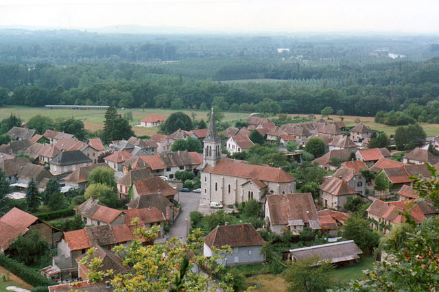
Champagneux (Champagneux)

- коммуна во Франции
 Hiking in Champagneux
Champagneux is a charming village located in the Savoie region of the French Alps, offering stunning natural landscapes, rich biodiversity, and a variety of hiking trails suitable for different skill levels. Here are some highlights to consider when hiking in Champagneux:
Trail Options
-
Local Trails: There are several marked trails around Champagneux that lead through forests, pastures, and rocky outcroppings. These trails often provide panoramic views of the surrounding mountains and valleys.
-
La Dent du Chat: A popular hike is to La Dent du Chat, which offers breathtaking views of Lake Bourget and the surrounding alpine scenery. The ascent can vary in difficulty—be sure to choose a route that suits your experience level.
-
Mont Charvin: For a more challenging hike, Mont Charvin is a great option. The trails here take you through varied terrain, including forests and alpine meadows, and the summit rewards you with 360-degree views of the Alps.
Trail Difficulty
- Beginner-friendly: There are many shorter, easier trails suitable for families and novice hikers, typically ranging from 1-3 hours.
- Intermediate: Moderate trails often last between 4-6 hours and include some elevation gain but are generally well-marked and accessible.
- Advanced: For seasoned hikers, options can include longer and steeper routes that may require some scrambling and good navigation skills.
Best Time to Hike
- Spring and Fall: These seasons offer mild weather conditions and fewer crowds. Wildflowers bloom in spring, adding to the scenery, while autumn provides beautiful foliage.
- Summer: Ideal for hiking, though it can be busy. Make sure to start early in the day to avoid the heat and crowds.
Preparation Tips
- Equipment: Wear sturdy hiking boots, and dress in layers. Bring a daypack with essentials like water, snacks, a first-aid kit, a map or GPS, and a fully charged phone.
- Weather Awareness: The weather can change rapidly in the mountains, so check forecasts and be prepared for rain, wind, or temperature changes.
- Leave No Trace: Respect the natural environment by following Leave No Trace principles—pack out what you pack in, stick to marked paths, and avoid disturbing wildlife.
Local Amenities
- Accommodations: Champagneux offers various options for accommodation, from guesthouses to campsites, which can be used as a base for your hiking adventures.
- Dining: After a day of hiking, you might want to relive your experiences over a meal at a local restaurant, where you can enjoy regional specialties and relax.
Always remember to check current trail conditions before heading out, as some paths may be affected by weather or maintenance work. Enjoy your hiking adventure in Champagneux!
- Страна:

- Почтовый код: 73240
- Координаты: 45° 37' 44" N, 5° 40' 26" E


- GPS треки (wikiloc): [Ссылка]
- Площадь: 10.68 кв.км
- Население: 679
- Википедия английская: wiki(en)
- Википедия национальная: wiki(fr)
- Хранилище Wikidata: Wikidata: Q941513
- Катеория в википедии: [Ссылка]
- код Freebase: [/m/03qlm26]
- код GeoNames: Альт: [6450994]
- номер SIREN: [217300706]
- код BNF: [152740040]
- код муниципалитета INSEE: 73070
Граничит с регионами:


Loisieux
- коммуна во Франции
Hiking in Loisieux
Loisieux is a picturesque village located in the Auvergne-Rhône-Alpes region of France, surrounded by stunning natural landscapes that make it an excellent base for hiking enthusiasts. While specific trails in Loisieux may not be widely known, the general area offers a variety of hiking opportunities suited to different skill levels....
- Страна:
- Почтовый код: 73170
- Координаты: 45° 39' 5" N, 5° 44' 6" E
- GPS треки (wikiloc): [Ссылка]
- Площадь: 9.33 кв.км
- Население: 197


La Balme
- коммуна во Франции
Hiking in La Balme
La Balme is a beautiful destination for hiking enthusiasts located in the French Alps. Here are some key highlights and considerations for hiking in La Balme:...
- Страна:
- Почтовый код: 73170
- Координаты: 45° 42' 22" N, 5° 43' 7" E
- GPS треки (wikiloc): [Ссылка]
- Площадь: 9.4 кв.км
- Население: 298
Бренье-Кордон
- коммуна во Франции
Hiking in Бренье-Кордон
Brégnier-Cordon is a charming village located in the Auvergne-Rhône-Alpes region of France, surrounded by stunning natural landscapes, making it an excellent destination for hiking enthusiasts. Here are some key points to consider when hiking in and around Brégnier-Cordon:...
- Страна:
- Почтовый код: 01300
- Координаты: 45° 38' 56" N, 5° 37' 11" E
- GPS треки (wikiloc): [Ссылка]
- Площадь: 11 кв.км
- Население: 856
- Веб сайт: [Ссылка]


Gresin
- коммуна во Франции
Hiking in Gresin
Gresin, located in the Aosta Valley region of Italy, is a wonderful destination for hiking enthusiasts. The area offers stunning mountainous landscapes, lush valleys, and a plethora of trails suitable for various skill levels....
- Страна:
- Почтовый код: 73240
- Координаты: 45° 36' 36" N, 5° 40' 57" E
- GPS треки (wikiloc): [Ссылка]
- Площадь: 5.01 кв.км
- Население: 387


Saint-Genix-sur-Guiers
- коммуна во Франции
Hiking in Saint-Genix-sur-Guiers
Saint-Genix-sur-Guiers is a charming commune located in the Rhône-Alpes region of France, known for its beautiful scenery and access to hiking trails. Nestled at the foot of the Chartreuse Mountains, it offers a variety of outdoor activities, including hiking, with trails that cater to different skill levels....
- Страна:
- Почтовый код: 73240
- Координаты: 45° 36' 2" N, 5° 38' 4" E
- GPS треки (wikiloc): [Ссылка]
- Площадь: 12.27 кв.км
- Население: 2384

Мюр-э-Желиньё
- коммуна во Франции
Hiking in Мюр-э-Желиньё
Murs-et-Gélignieux is a charming commune located in the Auvergne-Rhône-Alpes region of France, surrounded by beautiful landscapes that make it an ideal spot for hiking enthusiasts. When exploring this area, you'll encounter diverse terrains, scenic views, and rich natural beauty....
- Страна:
- Почтовый код: 01300
- Координаты: 45° 38' 29" N, 5° 39' 43" E
- GPS треки (wikiloc): [Ссылка]
- Площадь: 6.46 кв.км
- Население: 256
- Веб сайт: [Ссылка]


Saint-Maurice-de-Rotherens
- коммуна во Франции
Hiking in Saint-Maurice-de-Rotherens
Saint-Maurice-de-Rotherens is a lovely village located in the Savoie region of the French Alps. This area is rich in natural beauty, and it's an excellent destination for hiking enthusiasts. Here are some highlights and tips for hiking in and around Saint-Maurice-de-Rotherens:...
- Страна:
- Почтовый код: 73240
- Координаты: 45° 37' 16" N, 5° 41' 55" E
- GPS треки (wikiloc): [Ссылка]
- Площадь: 8.17 кв.км
- Население: 214