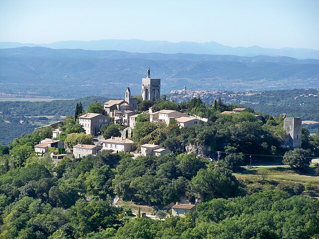
Chantemerle-lès-Grignan (Chantemerle-lès-Grignan)

- коммуна во Франции
 Hiking in Chantemerle-lès-Grignan
Chantemerle-lès-Grignan is a picturesque village located in the Drôme department of the Auvergne-Rhône-Alpes region of southeastern France. Its proximity to the stunning landscapes of the Provence region makes it an enticing destination for hikers. Here’s what you should know about hiking in this area:
Scenic Trails
The region offers a variety of hiking trails, ranging from easy walks to more challenging routes. The trails typically wind through beautiful vineyards, lavender fields, and the picturesque countryside, providing hikers with stunning views of the surrounding landscape.
Grignan and the Surrounding Area
One of the highlights of hiking near Chantemerle-lès-Grignan is the proximity to the village of Grignan, known for its historical château. There are several trails that connect these areas, allowing hikers to explore cultural landmarks alongside natural beauty.
The Gorges of the Eyrieux
If you are up for a slightly longer trek, consider venturing towards the Gorges of the Eyrieux, which offers breathtaking views of dramatic cliffs and lush forests. The trails here vary in difficulty but are often rewarded with stunning panoramas.
Wild Flora and Fauna
While hiking, you may encounter a diverse range of flora and fauna native to the region. Keep an eye out for local wildlife, including birds and various plant species, adding an educational aspect to your hiking experience.
Best Time to Hike
The best times to hike in this region are during spring and fall when temperatures are moderate, and the scenery is vibrant with wildflowers or autumn foliage. Summer can be hot, so it's advisable to carry plenty of water and wear appropriate sun protection.
Preparing for Your Hike
- Footwear: Wear sturdy hiking boots for better traction on the sometimes uneven terrain.
- Supplies: Bring water, snacks, a map or GPS, and a first aid kit.
- Weather Check: Always check the weather forecast before heading out, as conditions can change rapidly.
Guided Tours
For those unfamiliar with the area or seeking a more structured experience, consider joining guided hiking tours available in the region. These often provide insights into the local ecology and history.
Local Amenities
Chantemerle-lès-Grignan has local amenities such as small shops and cafes where you can refuel after a day of hiking. Exploring the village can also enrich your visit, as it embodies the charm of rural France.
Enjoy your hiking adventures in Chantemerle-lès-Grignan, and make sure to take plenty of photographs to capture the breathtaking scenery!
- Страна:

- Почтовый код: 26230
- Координаты: 44° 24' 11" N, 4° 50' 8" E


- GPS треки (wikiloc): [Ссылка]
- Площадь: 9.82 кв.км
- Население: 271
- Википедия английская: wiki(en)
- Википедия национальная: wiki(fr)
- Хранилище Wikidata: Wikidata: Q863718
- Катеория в википедии: [Ссылка]
- код Freebase: [/m/03mhfk0]
- код Freebase: [/m/03mhfk0]
- код GeoNames: Альт: [6447908]
- код GeoNames: Альт: [6447908]
- номер SIREN: [212600738]
- номер SIREN: [212600738]
- код BNF: [15252934h]
- код BNF: [15252934h]
- код муниципалитета INSEE: 26073
- код муниципалитета INSEE: 26073
Граничит с регионами:


Valaurie
- коммуна во Франции
Hiking in Valaurie
Valaurie is a beautiful village located in the Drôme department of the Auvergne-Rhône-Alpes region in southern France. It's a charming area that offers a mix of cultural heritage and natural beauty, making it a delightful destination for hiking enthusiasts....
- Страна:
- Почтовый код: 26230
- Координаты: 44° 25' 20" N, 4° 48' 49" E
- GPS треки (wikiloc): [Ссылка]
- Площадь: 12.3 кв.км
- Население: 589
- Веб сайт: [Ссылка]

Clansayes
- коммуна во Франции
- Страна:
- Почтовый код: 26130
- Координаты: 44° 22' 16" N, 4° 48' 27" E
- GPS треки (wikiloc): [Ссылка]
- Площадь: 14.47 кв.км
- Население: 516


Chamaret
- коммуна во Франции
Hiking in Chamaret
Chamaret is a charming village located in the Drôme department of southeastern France, known for its picturesque landscapes and proximity to vineyards and the stunning countryside of the Rhône-Alpes region. Hiking in and around Chamaret offers a unique experience, showcasing both natural beauty and local culture....
- Страна:
- Почтовый код: 26230
- Координаты: 44° 23' 47" N, 4° 52' 58" E
- GPS треки (wikiloc): [Ссылка]
- Площадь: 7.79 кв.км
- Население: 576


Гриньян
- коммуна во Франции
Hiking in Гриньян
Grignan is a picturesque village in the Drôme department of southeastern France, known for its stunning medieval architecture and beautiful surrounding landscapes. Hiking in this area can be an enriching experience, as the terrain offers a mix of flat paths and more challenging trails through vineyards, lavender fields, and mixed woodlands....
- Страна:
- Почтовый код: 26230
- Координаты: 44° 25' 10" N, 4° 54' 29" E
- GPS треки (wikiloc): [Ссылка]
- Площадь: 43.43 кв.км
- Население: 1534


Montségur-sur-Lauzon
- коммуна во Франции
Hiking in Montségur-sur-Lauzon
Montségur-sur-Lauzon is a charming village located in the Drôme department of the Auvergne-Rhône-Alpes region in southeastern France. It offers a variety of hiking opportunities amidst stunning natural scenery, including vineyards, aromatic fields, and the picturesque landscapes of the surrounding hills....
- Страна:
- Почтовый код: 26130
- Координаты: 44° 21' 38" N, 4° 51' 34" E
- GPS треки (wikiloc): [Ссылка]
- Площадь: 18.24 кв.км
- Население: 1268


Réauville
- коммуна во Франции
Hiking in Réauville
Réauville is a charming village located in the Drôme department of the Auvergne-Rhône-Alpes region in southeastern France. While not as widely known as some larger hiking destinations, Réauville and its surrounding area offer a variety of trails and scenic landscapes that can appeal to hikers of all skill levels....
- Страна:
- Почтовый код: 26230
- Координаты: 44° 26' 40" N, 4° 50' 39" E
- GPS треки (wikiloc): [Ссылка]
- Площадь: 18.22 кв.км
- Население: 382