Шантесс (Chantesse, Chantesse)

- коммуна во Франции
 Hiking in Шантесс
Chantesse, located in the picturesque region of France, offers a variety of hiking opportunities for both beginners and seasoned trekkers. It's nestled in the Vercors massif, which is known for its stunning landscapes, limestone cliffs, and diverse flora and fauna.
Key Hiking Routes:
-
Chemin des Écoliers: This trail is relatively easy and perfect for families. It winds through beautiful meadows and offers splendid views of the surrounding mountains.
-
Circuit de la Grande Moucherolle: A moderate hike that takes you to the summit of the Grande Moucherolle. The trail is a bit challenging but rewards hikers with panoramic views of the Vercors and beyond.
-
Col de l'Arc: This route provides a slightly tougher challenge and leads to the Col de l’Arc. It features diverse landscapes, including dense forests and steep ascents, and showcases the natural beauty of the region.
Essential Tips:
- Preparation: Check the weather conditions before heading out, as they can change rapidly in mountainous areas.
- Gear: Wear sturdy hiking boots and bring essentials such as water, snacks, a first-aid kit, and maps.
- Wildlife: Keep an eye out for local wildlife, including chamois and various bird species – binoculars can enhance your experience.
- Respect Nature: Stay on marked trails to preserve the natural environment and follow Leave No Trace principles.
Best Time to Visit:
The best seasons for hiking in Chantesse are late spring (May to June) and early autumn (September to October) when the weather is generally mild, and the trails are less crowded.
Whether you're looking for a peaceful walk or a more challenging hike, Chantesse has something to offer every hiking enthusiast. Enjoy your adventure!
- Страна:

- Почтовый код: 38470
- Координаты: 45° 14' 34" N, 5° 26' 40" E


- GPS треки (wikiloc): [Ссылка]
- Площадь: 5.83 кв.км
- Население: 320
- Веб сайт: http://chantesse.sud-gresivaudan.org
- Википедия русская: wiki(ru)
- Википедия английская: wiki(en)
- Википедия национальная: wiki(fr)
- Хранилище Wikidata: Wikidata: Q657431
- Катеория в википедии: [Ссылка]
- код Freebase: [/m/03nvgbc]
- код GeoNames: Альт: [6448746]
- номер SIREN: [213800741]
- код BNF: [15257903f]
- код муниципалитета INSEE: 38074
Граничит с регионами:


Крас
- коммуна во Франции
Hiking in Крас
Cras, located in the Isère department of the Auvergne-Rhône-Alpes region in southeastern France, provides an excellent backdrop for hiking enthusiasts. The area is known for its stunning mountain landscapes, diverse flora and fauna, and well-marked trails. Here are some key points to consider when hiking in Cras:...
- Страна:
- Почтовый код: 38210
- Координаты: 45° 16' 8" N, 5° 27' 0" E
- GPS треки (wikiloc): [Ссылка]
- Площадь: 5.43 кв.км
- Население: 448
- Веб сайт: [Ссылка]


Л’Альбенк
- коммуна во Франции
Hiking in Л’Альбенк
L'Albenc is a charming village located in the Auvergne-Rhône-Alpes region of southeastern France. The area surrounding L'Albenc offers a range of hiking opportunities suited for various skill levels, with stunning views of the surrounding mountains and valleys....
- Страна:
- Почтовый код: 38470
- Координаты: 45° 13' 30" N, 5° 26' 26" E
- GPS треки (wikiloc): [Ссылка]
- Площадь: 9.86 кв.км
- Население: 1170
- Веб сайт: [Ссылка]


Ватильё
- коммуна во Франции
Hiking in Ватильё
Vatilieu is a charming commune located in the Isère department in the Auvergne-Rhône-Alpes region of southeastern France. Although it may not be as widely known as other hiking destinations, the surrounding area offers beautiful landscapes and opportunities for outdoor activities like hiking....
- Страна:
- Почтовый код: 38470
- Координаты: 45° 15' 22" N, 5° 24' 38" E
- GPS треки (wikiloc): [Ссылка]
- Площадь: 9.22 кв.км
- Население: 370
- Веб сайт: [Ссылка]
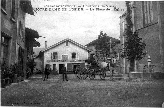
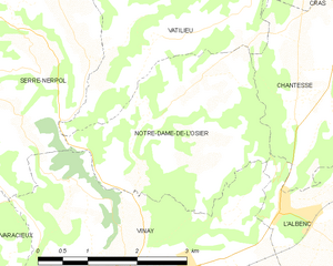
Нотр-Дам-де-л'Озье
- коммуна во Франции
Hiking in Нотр-Дам-де-л'Озье
Notre-Dame-de-l'Osier, located in the Isère department of France, is a charming village surrounded by stunning natural landscapes, making it an excellent destination for hiking enthusiasts. Here are some highlights:...
- Страна:
- Почтовый код: 38470
- Координаты: 45° 14' 18" N, 5° 24' 19" E
- GPS треки (wikiloc): [Ссылка]
- Площадь: 8.38 кв.км
- Население: 478
- Веб сайт: [Ссылка]

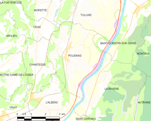
Польенас
- коммуна во Франции
Hiking in Польенас
Poliénas, a charming commune in the Isère department of southeastern France, is well situated for outdoor activities, including hiking. Nestled near the foothills of the Alps, the area offers stunning natural landscapes, diverse terrain, and numerous trails suitable for various skill levels....
- Страна:
- Почтовый код: 38210
- Координаты: 45° 14' 56" N, 5° 28' 17" E
- GPS треки (wikiloc): [Ссылка]
- Площадь: 14.03 кв.км
- Население: 1150
- Веб сайт: [Ссылка]