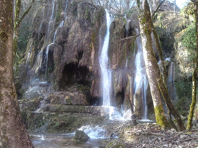
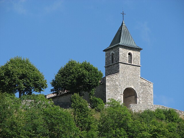
Шеньё-ла-Бальм (Cheignieu-la-Balme, Cheignieu-la-Balme)
- коммуна во Франции
 Hiking in Шеньё-ла-Бальм
Cheignieu-la-Balme is a charming commune located in the Ain department of the Auvergne-Rhône-Alpes region in southeastern France. The area is known for its picturesque landscapes, rolling hills, forests, and proximity to the Rhône River, making it a wonderful place for hiking enthusiasts.
Hiking Opportunities:
-
Scenic Trails: The region offers various hiking trails that cater to different skill levels, from easy walks suitable for families to more challenging hikes for experienced hikers. The trails often wind through forests, past rivers, and over hills, providing stunning views of the surrounding countryside.
-
Nature and Wildlife: While hiking in Cheignieu-la-Balme, you can encounter diverse flora and fauna. The forests may be home to deer, various bird species, and other wildlife, making it a rewarding experience for nature lovers and birdwatchers.
-
Local Hiking Guides: If you're unfamiliar with the area, consider hiring a local guide or joining a guided hike. They can provide invaluable knowledge about the region's ecology, history, and best hiking spots.
-
Cultural Sites: Along your hikes, you might find interesting cultural landmarks, including traditional farms and historical sites that give insight into the local heritage.
Tips for Hiking in Cheignieu-la-Balme:
-
Trail Maps: Before setting out, obtain a trail map or use a hiking app that provides GPS tracking. This will help ensure you stick to marked paths.
-
Footwear: Wear sturdy hiking boots to provide adequate support and grip, particularly if you plan on tackling rough or uneven terrain.
-
Safety: Always inform someone about your hiking plans, carry a first aid kit, and ensure you have sufficient water and snacks.
-
Weather Conditions: Check the weather forecasts before heading out. The region can experience varying weather conditions, so be prepared for changes.
Whether you are looking for a peaceful stroll in nature or a more rigorous hiking experience, Cheignieu-la-Balme offers a beautiful setting and plenty of trails to explore.
- Страна:

- Почтовый код: 01510
- Координаты: 45° 49' 38" N, 5° 36' 28" E


- GPS треки (wikiloc): [Ссылка]
- Площадь: 6.26 кв.км
- Население: 139
- Википедия русская: wiki(ru)
- Википедия английская: wiki(en)
- Википедия национальная: wiki(fr)
- Хранилище Wikidata: Wikidata: Q590958
- Катеория в википедии: [Ссылка]
- Карты в википедии: [Ссылка]
- код Freebase: [/m/03cz04l]
- код Freebase: [/m/03cz04l]
- код Freebase: [/m/03cz04l]
- код GeoNames: Альт: [6618071]
- код GeoNames: Альт: [6618071]
- код GeoNames: Альт: [6618071]
- номер SIREN: [210101002]
- номер SIREN: [210101002]
- номер SIREN: [210101002]
- код муниципалитета INSEE: 01100
- код муниципалитета INSEE: 01100
- код муниципалитета INSEE: 01100
Граничит с регионами:
Вирьё-ле-Гран
- коммуна во Франции
Hiking in Вирьё-ле-Гран
Virieu-le-Grand is a charming village located in the Auvergne-Rhône-Alpes region of France, nestled between beautiful natural landscapes, making it a great destination for hiking enthusiasts. The area offers several hiking trails that vary in difficulty, catering to both beginners and experienced hikers....
- Страна:
- Почтовый код: 01510
- Координаты: 45° 50' 57" N, 5° 39' 6" E
- GPS треки (wikiloc): [Ссылка]
- Площадь: 12.55 кв.км
- Население: 1067
- Веб сайт: [Ссылка]

Ла-Бюрбанш
- коммуна во Франции
Hiking in Ла-Бюрбанш
La Burbanche is a picturesque mountainous region located in the Rhône-Alpes area of France, known for its beautiful landscapes, scenic views, and hiking opportunities. It is situated near the Chartreuse Mountains and offers a variety of trails suitable for different skill levels, making it an excellent destination for hikers....
- Страна:
- Почтовый код: 01510
- Координаты: 45° 50' 48" N, 5° 33' 38" E
- GPS треки (wikiloc): [Ссылка]
- Площадь: 10.82 кв.км
- Население: 71
Эннимон
- коммуна во Франции
Hiking in Эннимон
Innimond is a beautiful area for hiking, characterized by its stunning natural scenery and diverse terrain. Although specific trail details may vary, here are some general tips and information about hiking in the Innimond region:...
- Страна:
- Почтовый код: 01680
- Координаты: 45° 46' 58" N, 5° 34' 21" E
- GPS треки (wikiloc): [Ссылка]
- Площадь: 13.44 кв.км
- Население: 106

Пюжьё
- коммуна во Франции
Hiking in Пюжьё
Pugieu is a small village located in the Auvergne-Rhône-Alpes region of France, surrounded by beautiful natural scenery that makes it an appealing destination for hiking enthusiasts. While Pugieu itself may not be widely known for specific hiking trails, the surrounding areas, including the Jura Mountains and other nearby natural parks, offer a range of trails suited for various skill levels....
- Страна:
- Почтовый код: 01510
- Координаты: 45° 49' 16" N, 5° 38' 57" E
- GPS треки (wikiloc): [Ссылка]
- Площадь: 4.85 кв.км
- Население: 151

Контрево
- коммуна во Франции
Hiking in Контрево
Contrevoz is a small commune located in the Ain department of the Auvergne-Rhône-Alpes region in eastern France. While it may not be as widely known as some other hiking destinations, it offers a great opportunity to explore the natural beauty of the area....
- Страна:
- Почтовый код: 01300
- Координаты: 45° 48' 22" N, 5° 37' 42" E
- GPS треки (wikiloc): [Ссылка]
- Площадь: 14.18 кв.км
- Население: 503
- Веб сайт: [Ссылка]

Российон
- коммуна во Франции
Hiking in Российон
Rossillon is a charming village located in the region of Provence in southeastern France. While it’s not as well-known as some of the more prominent hiking destinations in the region, it offers beautiful landscapes and a more tranquil hiking experience. Here’s what you can expect when hiking in and around Rossillon:...
- Страна:
- Почтовый код: 01510
- Координаты: 45° 49' 55" N, 5° 35' 37" E
- GPS треки (wikiloc): [Ссылка]
- Площадь: 8.07 кв.км
- Население: 150

Ордонна
- коммуна во Франции
Hiking in Ордонна
Ordonnaz is a small commune located in the Auvergne-Rhône-Alpes region of southeastern France, nestled at the foot of the Alps. This area offers picturesque landscapes, making it a delightful destination for hiking enthusiasts....
- Страна:
- Почтовый код: 01510
- Координаты: 45° 50' 14" N, 5° 32' 18" E
- GPS треки (wikiloc): [Ссылка]
- Площадь: 14.88 кв.км
- Население: 152