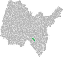
Ордонна (Ordonnaz, Ordonnaz)
- коммуна во Франции
 Hiking in Ордонна
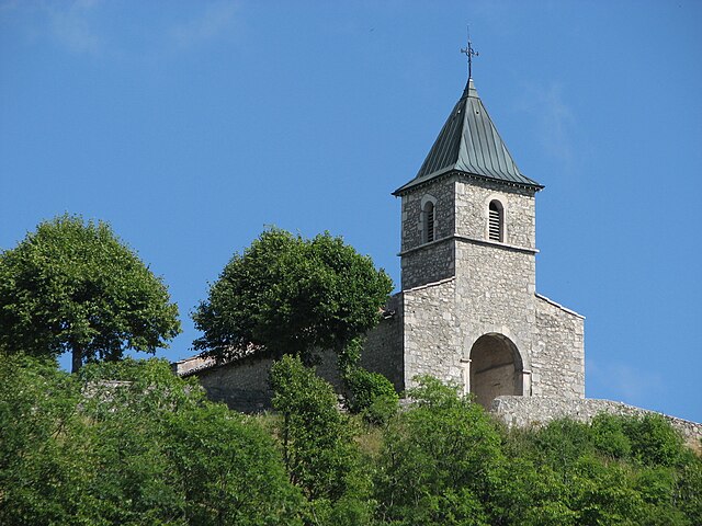
Ordonnaz is a small commune located in the Auvergne-Rhône-Alpes region of southeastern France, nestled at the foot of the Alps. This area offers picturesque landscapes, making it a delightful destination for hiking enthusiasts.
Hiking Trails
- Local Trails: The surrounding mountains offer numerous trails ranging from easy walks to more challenging hikes. Many trails provide stunning views of the Alps and the surrounding valleys.
- Nature Reserves: The region often features nature reserves where you can experience local flora and fauna, adding an educational aspect to your hike.
- Markers and Signage: Trails are usually well-marked, allowing hikers to navigate easily. It's recommended to carry a detailed map or a GPS.
Difficulty Levels
- Beginner: There are several easier trails suitable for families and less experienced hikers.
- Intermediate and Advanced: More challenging options are available for seasoned hikers looking for a good workout and breathtaking views.
Best Time to Hike
- Spring and Fall: These seasons offer mild weather and beautiful scenery, with wildflowers in the spring and colorful foliage in the fall.
- Summer: While temperatures are warmer, it's essential to start hikes early in the day to avoid heat and ensure you have time to complete your hike.
Preparation
- Equipment: Good hiking boots, appropriate clothing, and a backpack with water and snacks are essential. Trekking poles may be beneficial for steeper trails.
- Safety: Always inform someone of your hike plan, check the weather forecast, and be prepared for sudden weather changes.
Nearby Attractions
- Explore nearby villages for cultural experiences or local cuisine, enhancing your overall hiking adventure.
- Consider engaging in other activities, such as mountain biking or visiting local historical sites.
Conclusion
Hiking in Ordonnaz can provide a wonderful experience amid stunning natural beauty and diverse landscapes. Whether you're a beginner or an experienced hiker, the area has trails that cater to all skill levels. Enjoy your adventure!
- Страна:

- Почтовый код: 01510
- Координаты: 45° 50' 14" N, 5° 32' 18" E


- GPS треки (wikiloc): [Ссылка]
- Площадь: 14.88 кв.км
- Население: 152
- Википедия русская: wiki(ru)
- Википедия английская: wiki(en)
- Википедия национальная: wiki(fr)
- Хранилище Wikidata: Wikidata: Q988672
- Катеория в википедии: [Ссылка]
- Карты в википедии: [Ссылка]
- код Freebase: [/m/081796]
- код Freebase: [/m/081796]
- код Freebase: [/m/081796]
- код GeoNames: Альт: [6424611]
- код GeoNames: Альт: [6424611]
- код GeoNames: Альт: [6424611]
- номер SIREN: [210102802]
- номер SIREN: [210102802]
- номер SIREN: [210102802]
- код муниципалитета INSEE: 01280
- код муниципалитета INSEE: 01280
- код муниципалитета INSEE: 01280
Граничит с регионами:

Бенонс
- коммуна во Франции
Hiking in Бенонс
Bénonces, a lesser-known area for hiking, is blessed with natural beauty and a variety of trails that cater to different skill levels. While specific details about Bénonces might not be widely documented, you can generally expect the following when hiking in similar regions:...
- Страна:
- Почтовый код: 01470
- Координаты: 45° 49' 40" N, 5° 28' 31" E
- GPS треки (wikiloc): [Ссылка]
- Площадь: 15.33 кв.км
- Население: 288
- Веб сайт: [Ссылка]

Аранда
- коммуна в департаменте Эн, Франция
Hiking in Аранда
Arandas, located in the Ain department in the Auvergne-Rhône-Alpes region of France, offers some stunning hiking opportunities with a mix of beautiful landscapes and diverse terrain. The area is characterized by rolling hills, valleys, and a variety of flora and fauna, making it ideal for both casual walkers and more experienced hikers....
- Страна:
- Почтовый код: 01230
- Координаты: 45° 53' 42" N, 5° 29' 11" E
- GPS треки (wikiloc): [Ссылка]
- Площадь: 14.1 кв.км
- Население: 153

Шеньё-ла-Бальм
- коммуна во Франции
Hiking in Шеньё-ла-Бальм
Cheignieu-la-Balme is a charming commune located in the Ain department of the Auvergne-Rhône-Alpes region in southeastern France. The area is known for its picturesque landscapes, rolling hills, forests, and proximity to the Rhône River, making it a wonderful place for hiking enthusiasts....
- Страна:
- Почтовый код: 01510
- Координаты: 45° 49' 38" N, 5° 36' 28" E
- GPS треки (wikiloc): [Ссылка]
- Площадь: 6.26 кв.км
- Население: 139

Ла-Бюрбанш
- коммуна во Франции
Hiking in Ла-Бюрбанш
La Burbanche is a picturesque mountainous region located in the Rhône-Alpes area of France, known for its beautiful landscapes, scenic views, and hiking opportunities. It is situated near the Chartreuse Mountains and offers a variety of trails suitable for different skill levels, making it an excellent destination for hikers....
- Страна:
- Почтовый код: 01510
- Координаты: 45° 50' 48" N, 5° 33' 38" E
- GPS треки (wikiloc): [Ссылка]
- Площадь: 10.82 кв.км
- Население: 71
Эннимон
- коммуна во Франции
Hiking in Эннимон
Innimond is a beautiful area for hiking, characterized by its stunning natural scenery and diverse terrain. Although specific trail details may vary, here are some general tips and information about hiking in the Innimond region:...
- Страна:
- Почтовый код: 01680
- Координаты: 45° 46' 58" N, 5° 34' 21" E
- GPS треки (wikiloc): [Ссылка]
- Площадь: 13.44 кв.км
- Население: 106

Конан
- коммуна во Франции
Hiking in Конан
Conand, located in the Ain department in the Auvergne-Rhône-Alpes region of France, offers a picturesque setting for hiking enthusiasts. While Conand itself is a small commune, it is surrounded by beautiful landscapes, including rolling hills, forests, and nearby mountains....
- Страна:
- Почтовый код: 01230
- Координаты: 45° 53' 33" N, 5° 28' 16" E
- GPS треки (wikiloc): [Ссылка]
- Площадь: 15.28 кв.км
- Население: 118

Лонна
- коммуна во Франции
Hiking in Лонна
Lompnas is not a well-known hiking destination, so it's possible you might be referring to a specific trail or area that goes by a different name, or it may be a less documented location. If you meant a different region or if there's a specific trail you have in mind, feel free to provide more details!...
- Страна:
- Почтовый код: 01680
- Координаты: 45° 48' 11" N, 5° 31' 13" E
- GPS треки (wikiloc): [Ссылка]
- Площадь: 12.69 кв.км
- Население: 167
- Веб сайт: [Ссылка]