Chindrieux (Chindrieux)

- коммуна во Франции
 Hiking in Chindrieux
Chindrieux is a charming village located in the Savoie region of the French Alps, near the shores of Lake Bourget. This picturesque area offers a variety of hiking opportunities that cater to different skill levels, making it a great destination for both casual walkers and experienced hikers.
Key Highlights of Hiking in Chindrieux:
-
Scenic Trails: The trails around Chindrieux provide stunning views of Lake Bourget, the largest natural lake in France, and the surrounding mountains, including the Bauges and the Chartreuse ranges. The lush landscapes and diverse flora and fauna make for a visually captivating experience.
-
Local Trails: Explore well-marked hiking routes such as:
- The Lake Circuit: A relatively easy trail that circles part of Lake Bourget, suitable for families and those looking for a leisurely walk.
- Mont d'Artois: A more challenging hike that provides panoramic views of the region.
-
Cultural Experience: While hiking, you can discover the local culture, traditional architecture, and historical sites. The village itself has a quaint charm, with cottages and small shops that reflect the region's heritage.
-
Wildlife: The area is home to various species of wildlife, including birds, deer, and other native animals. Early morning or late afternoon hikes can provide the best chances of spotting wildlife.
-
Seasonal Considerations: The best times for hiking in Chindrieux are spring through early autumn when the weather is mild, and the trails are accessible. Be mindful of snow and icy conditions in winter, which can limit trail accessibility.
-
Safety and Preparation: As with any hiking activity, ensure you are well-prepared with appropriate clothing, equipment, and sufficient water. It's also advisable to check local trail conditions, weather forecasts, and trail maps before heading out.
-
Local Guides: Consider hiring a local guide if you're looking for a deeper understanding of the area's ecology, history, or if you are unfamiliar with the terrain.
Whether you're looking to enjoy a short stroll or embark on a longer trek, Chindrieux offers a serene and scenic environment for outdoor enthusiasts. Always respect nature and follow Leave No Trace principles to help maintain the beauty of the area for future visitors.
- Страна:

- Почтовый код: 73310
- Координаты: 45° 49' 17" N, 5° 51' 8" E


- GPS треки (wikiloc): [Ссылка]
- Площадь: 16.42 кв.км
- Население: 1344
- Википедия английская: wiki(en)
- Википедия национальная: wiki(fr)
- Хранилище Wikidata: Wikidata: Q841386
- Катеория в википедии: [Ссылка]
- код Freebase: [/m/025wl_g]
- код GeoNames: Альт: [6450998]
- номер SIREN: [217300854]
- код BNF: [152740191]
- код муниципалитета INSEE: 73085
Граничит с регионами:

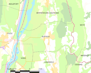
Ruffieux
- коммуна во Франции
Hiking in Ruffieux
Ruffieux is a charming village located in the Savoie department of the Auvergne-Rhône-Alpes region in southeastern France. It is nestled in the stunning landscape of the French Alps, providing hikers with a myriad of options for outdoor exploration....
- Страна:
- Почтовый код: 73310
- Координаты: 45° 50' 57" N, 5° 50' 38" E
- GPS треки (wikiloc): [Ссылка]
- Площадь: 13.21 кв.км
- Население: 856


Conjux
- коммуна во Франции
Hiking in Conjux
Conjux is a small but beautiful area located in the Savoie region of the French Alps, near Lake Bourget. While it's less known than some larger hiking destinations in the Alps, it offers a variety of trails and stunning natural scenery, making it a great destination for hiking enthusiasts....
- Страна:
- Почтовый код: 73310
- Координаты: 45° 47' 26" N, 5° 49' 17" E
- GPS треки (wikiloc): [Ссылка]
- Площадь: 1.7 кв.км
- Население: 202
Saint-Germain-la-Chambotte
- коммуна во Франции
Hiking in Saint-Germain-la-Chambotte
Saint-Germain-la-Chambotte is a picturesque village located in the Haute-Savoie region of southeastern France. Nestled in the French Alps, it offers breathtaking views and a variety of hiking opportunities suitable for different skill levels. Here’s what you can expect when hiking in this beautiful area:...
- Страна:
- Почтовый код: 73410
- Координаты: 45° 46' 41" N, 5° 53' 30" E
- GPS треки (wikiloc): [Ссылка]
- Площадь: 9.64 кв.км
- Население: 512


Cessens
- коммуна во Франции
Hiking in Cessens
Cessens is a charming village located in the Auvergne-Rhône-Alpes region of France, known for its stunning natural scenery and outdoor activities, making it a great spot for hiking enthusiasts. Here are some details about hiking in and around Cessens:...
- Страна:
- Почтовый код: 73410
- Координаты: 45° 47' 58" N, 5° 52' 55" E
- GPS треки (wikiloc): [Ссылка]
- Площадь: 13.29 кв.км
- Население: 403


Vions
- коммуна во Франции
Hiking in Vions
It seems there might be a typo in your query, as "Vions" does not correspond to a well-known hiking destination. However, if you meant "Vions" as a specific location or region, please provide a bit more context or clarify the name....
- Страна:
- Почтовый код: 73310
- Координаты: 45° 49' 28" N, 5° 48' 25" E
- GPS треки (wikiloc): [Ссылка]
- Площадь: 5.7 кв.км
- Население: 410


Chanaz
- коммуна во Франции
Hiking in Chanaz
Chanaz, often referred to as the "Venice of the Savoy," is a picturesque village located in the Auvergne-Rhône-Alpes region of France, near the Rhône River and surrounded by stunning natural landscapes. The area is known for its scenic routes and opportunities for hiking, making it an excellent destination for outdoor enthusiasts....
- Страна:
- Почтовый код: 73310
- Координаты: 45° 48' 31" N, 5° 47' 35" E
- GPS треки (wikiloc): [Ссылка]
- Площадь: 6.75 кв.км
- Население: 507
- Веб сайт: [Ссылка]