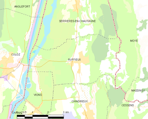
canton of Ruffieux (canton de Ruffieux)
 Hiking in canton of Ruffieux
Canton de Ruffieux, located in the Savoie department of the Auvergne-Rhône-Alpes region in France, offers a variety of hiking opportunities that cater to different skill levels and preferences. The picturesque landscape features rolling hills, lush forests, and stunning views of the surrounding mountains, including the Bauges and Chartreuse ranges.
Popular Hiking Trails
-
Le Mont Granier: This hike is quite popular and offers breathtaking views from the summit. The trail can be steep in sections but rewards hikers with panoramic vistas of the surrounding areas.
-
Les Gorges du Sierroz: This trail offers a scenic experience alongside the Sierroz River. The gorges are accessible and provide an excellent environment for families or those looking for a more relaxed hike.
-
Tour des Bauges: This is a longer trek that circles around the Bauges region, allowing hikers to experience various terrains and landscapes. It can be done as a multi-day hike, with several refuge options along the way.
Season and Preparation
-
Best Time to Hike: The best time for hiking in Canton de Ruffieux is typically from late spring to early autumn (May to October) when the weather is mild and the trails are accessible.
-
Equipment: Depending on the trail, proper footwear, hydration packs, and appropriate clothing for changing weather conditions are essential. If you plan to hike at higher elevations, consider bringing layers and a map or GPS device.
Wildlife and Nature
The area is rich in biodiversity, home to various flora and fauna. Keep an eye out for local wildlife, including deer, birds, and unique plant species. As you hike, make sure to respect the natural environment and follow Leave No Trace principles.
Local Culture
While hiking, you can also experience the local culture, including traditional Savoyard cuisine. After a day of exploring the trails, consider visiting local restaurants and enjoying dishes like fondue or tartiflette, which reflect the region's culinary heritage.
Safety Tips
- Always inform someone about your hiking plans before heading out.
- Check the weather forecast to avoid adverse conditions.
- Carry a first aid kit and basic survival gear, especially on longer hikes.
Overall, hiking in Canton de Ruffieux can be a rewarding experience, showcasing the beauty of the French Alps while providing opportunities for adventure and relaxation.
- Страна:

- Столица: Ruffieux
- Координаты: 45° 50' 1" N, 5° 49' 37" E


- GPS треки (wikiloc): [Ссылка]
- Хранилище Wikidata: Wikidata: Q1727028
- код кантона INSEE: [7323]
Включает регионы:


Motz
- коммуна во Франции
Hiking in Motz
Motz, a small municipality located in the Savoie region of France, is nestled in the beautiful alpine environment near the Mont Blanc massif and the French Alps. This location is known for its stunning landscapes, picturesque mountains, and diverse hiking opportunities. Here are some key aspects of hiking in and around Motz:...
- Страна:
- Почтовый код: 73310
- Координаты: 45° 55' 11" N, 5° 50' 52" E
- GPS треки (wikiloc): [Ссылка]
- Площадь: 9.04 кв.км
- Население: 432
- Веб сайт: [Ссылка]

Ruffieux
- коммуна во Франции
Hiking in Ruffieux
Ruffieux is a charming village located in the Savoie department of the Auvergne-Rhône-Alpes region in southeastern France. It is nestled in the stunning landscape of the French Alps, providing hikers with a myriad of options for outdoor exploration....
- Страна:
- Почтовый код: 73310
- Координаты: 45° 50' 57" N, 5° 50' 38" E
- GPS треки (wikiloc): [Ссылка]
- Площадь: 13.21 кв.км
- Население: 856

Serrières-en-Chautagne
- коммуна во Франции
Hiking in Serrières-en-Chautagne
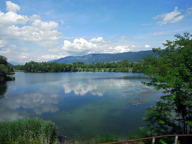
Serrières-en-Chautagne, located in the Savoie department of the Auvergne-Rhône-Alpes region in France, offers beautiful hiking opportunities amidst picturesque landscapes. The region is known for its diverse terrain, including hills, forests, and proximity to Lake Bourget, which is the largest natural lake in France....
- Страна:
- Почтовый код: 73310
- Координаты: 45° 52' 56" N, 5° 50' 34" E
- GPS треки (wikiloc): [Ссылка]
- Площадь: 16.04 кв.км
- Население: 1212


Conjux
- коммуна во Франции
Hiking in Conjux
Conjux is a small but beautiful area located in the Savoie region of the French Alps, near Lake Bourget. While it's less known than some larger hiking destinations in the Alps, it offers a variety of trails and stunning natural scenery, making it a great destination for hiking enthusiasts....
- Страна:
- Почтовый код: 73310
- Координаты: 45° 47' 26" N, 5° 49' 17" E
- GPS треки (wikiloc): [Ссылка]
- Площадь: 1.7 кв.км
- Население: 202


Сен-Пьер-де-Кюртий
- коммуна во Франции
Hiking in Сен-Пьер-де-Кюртий
Saint-Pierre-de-Curtille, located in the Savoie region of France near the shores of Lake Bourget, offers a beautiful setting for hiking enthusiasts. The area is characterized by stunning natural landscapes, including forests, hills, and views of the lake and surrounding mountains....
- Страна:
- Почтовый код: 73310
- Координаты: 45° 46' 32" N, 5° 48' 41" E
- GPS треки (wikiloc): [Ссылка]
- Площадь: 9.75 кв.км
- Население: 495
- Веб сайт: [Ссылка]


Vions
- коммуна во Франции
Hiking in Vions
It seems there might be a typo in your query, as "Vions" does not correspond to a well-known hiking destination. However, if you meant "Vions" as a specific location or region, please provide a bit more context or clarify the name....
- Страна:
- Почтовый код: 73310
- Координаты: 45° 49' 28" N, 5° 48' 25" E
- GPS треки (wikiloc): [Ссылка]
- Площадь: 5.7 кв.км
- Население: 410


Chanaz
- коммуна во Франции
Hiking in Chanaz
Chanaz, often referred to as the "Venice of the Savoy," is a picturesque village located in the Auvergne-Rhône-Alpes region of France, near the Rhône River and surrounded by stunning natural landscapes. The area is known for its scenic routes and opportunities for hiking, making it an excellent destination for outdoor enthusiasts....
- Страна:
- Почтовый код: 73310
- Координаты: 45° 48' 31" N, 5° 47' 35" E
- GPS треки (wikiloc): [Ссылка]
- Площадь: 6.75 кв.км
- Население: 507
- Веб сайт: [Ссылка]


Chindrieux
- коммуна во Франции
Hiking in Chindrieux
Chindrieux is a charming village located in the Savoie region of the French Alps, near the shores of Lake Bourget. This picturesque area offers a variety of hiking opportunities that cater to different skill levels, making it a great destination for both casual walkers and experienced hikers....
- Страна:
- Почтовый код: 73310
- Координаты: 45° 49' 17" N, 5° 51' 8" E
- GPS треки (wikiloc): [Ссылка]
- Площадь: 16.42 кв.км
- Население: 1344