
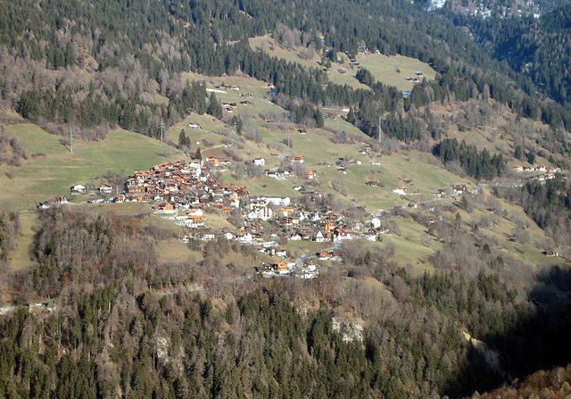
Кур (Chur, Chur)

- община в Швейцарии, Граубюнден
 Hiking in Кур
Chur, the capital of the Graubünden canton in Switzerland, offers a fantastic array of hiking opportunities. Nestled in the heart of the Alps, it boasts stunning landscapes that attract both beginner and experienced hikers. Here are some key highlights about hiking in and around Chur:
-
Diverse Trails: Chur is surrounded by a variety of hiking trails that vary in difficulty and length. You can find everything from leisurely walks through picturesque meadows to challenging alpine hikes.
-
Hiking from Chur to Brambrüesch: One of the popular routes is the hike from Chur to Brambrüesch, which can be reached via a cable car. The trail features beautiful views and is suitable for families. In the summer months, the region is known for its alpine flowers.
-
Chur's Old Town: Before or after your hike, take time to explore Chur’s charming old town, which has a rich history and lovely medieval architecture. It’s a great place to relax and enjoy local cuisine.
-
Parpaner Rothorn: For more experienced hikers, the trail to Parpaner Rothorn offers breathtaking panoramic views of the surrounding mountains and valleys. This hike typically requires more endurance and may involve steeper sections.
-
Wildlife and Nature: Hiking around Chur gives you the chance to encounter a variety of wildlife, including marmots, ibex, and diverse bird species. The area is rich in biodiversity.
-
Seasonal Hiking: Depending on the season, trails can offer different experiences. Spring and summer are ideal for wildflowers and green landscapes, while autumn showcases beautiful foliage. Snowshoeing and winter hiking are options in the winter months.
-
Signposted Trails: The trails in the Chur region are well-signposted, and maps are available at tourist information centers. It’s advisable to check trail conditions and weather forecasts before heading out.
-
Accommodations: There are various accommodation options available in Chur, from hotels to guesthouses, making it a convenient base for hiking trips.
Always remember to prepare adequately for your hikes, considering your fitness level, weather conditions, and bringing plenty of water and food. Happy hiking!
- Страна:

- Почтовый код: 6969
- Телефонный код: 081
- Код автомобильного номера: GR
- Координаты: 46° 51' 8" N, 9° 31' 47" E


- GPS треки (wikiloc): [Ссылка]
- Высота над уровнем моря: 593 м m
- Площадь: 28.09 кв.км
- Население: 35038
- Веб сайт: http://www.chur.ch
- Википедия русская: wiki(ru)
- Википедия английская: wiki(en)
- Википедия национальная: wiki(de)
- Хранилище Wikidata: Wikidata: Q69007
- Галерея изображений в википедии: [Ссылка]
- Катеория в википедии: [Ссылка]
- код Freebase: [/m/016vjp]
- код GeoNames: Альт: [7285515]
- код BNF: [12369126b]
- код VIAF: Альт: [154757544]
- ID отношения в OpenStreetMap: [1684063]
- код GND: Альт: [4010189-7]
- идентификатор местоположения ArchINFORM: [1538]
- код LCNAF: Альт: [n79064879]
- место в MusicBrainz: [7cb283d1-a165-41f9-87f4-b974dfbdfe47]
- код темы Quora: [Chur]
- код SUDOC: [027428575]
- код в энциклопедии «Британника онлайн»: [place/Chur]
- идентификатор HDS: [1581]
- код места в Facebook: [106239312747810]
- код в Большой российской энциклопедии онлайн: [2122787]
- код швейцарского муниципалитета: [3901]
- код в Итальянской энциклопедии онлайн: [coira]
Граничит с регионами:


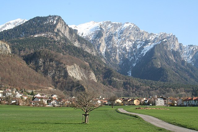
Курвальден
Hiking in Курвальден
Churwalden, located in the Prättigau Valley of Switzerland, is a fantastic destination for hiking enthusiasts. Nestled in the picturesque Graubünden region, it offers a variety of scenic trails suitable for different skill levels and preferences. Here are some details to help you plan your hiking experience in Churwalden:...
- Страна:
- Почтовый код: 7075
- Телефонный код: 081
- Код автомобильного номера: GR
- Координаты: 46° 47' 21" N, 9° 32' 20" E
- GPS треки (wikiloc): [Ссылка]
- Высота над уровнем моря: 1159 м m
- Площадь: 48.54 кв.км
- Население: 2012
- Веб сайт: [Ссылка]


Фельсберг
Hiking in Фельсберг
Felsberg, located in the canton of Graubünden in Switzerland, offers a variety of hiking experiences amidst stunning natural beauty. With its picturesque landscapes, including mountains, valleys, and rivers, Felsberg serves as a great base for both novice and experienced hikers....
- Страна:
- Почтовый код: 7012
- Телефонный код: 081
- Код автомобильного номера: GR
- Координаты: 46° 49' 59" N, 9° 27' 59" E
- GPS треки (wikiloc): [Ссылка]
- Высота над уровнем моря: 572 м m
- Площадь: 13.40 кв.км
- Население: 2569
- Веб сайт: [Ссылка]

Маладерс
Hiking in Маладерс
Maladers, located near the beautiful region of Graubünden in Switzerland, is an excellent destination for hiking enthusiasts. The area offers stunning views of the surrounding mountains, lush valleys, and a variety of trails suitable for different skill levels....
- Страна:
- Почтовый код: 7026
- Телефонный код: 081
- Код автомобильного номера: GR
- Координаты: 46° 50' 41" N, 9° 34' 20" E
- GPS треки (wikiloc): [Ссылка]
- Высота над уровнем моря: 1353 м m
- Площадь: 7.59 кв.км
- Население: 505
- Веб сайт: [Ссылка]


Хальденштайн
Hiking in Хальденштайн
Haldenstein, located in the canton of Graubünden in Switzerland, is an excellent destination for hiking enthusiasts. The area is known for its stunning landscapes, picturesque views, and a variety of hiking trails that cater to different skill levels....
- Страна:
- Почтовый код: 7023
- Телефонный код: 081
- Код автомобильного номера: GR
- Координаты: 46° 52' 43" N, 9° 31' 37" E
- GPS треки (wikiloc): [Ссылка]
- Высота над уровнем моря: 1557 м m
- Площадь: 18.56 кв.км
- Население: 1025
- Веб сайт: [Ссылка]


Домат-Эмс
Hiking in Домат-Эмс
Domat/Ems is a picturesque village located in the canton of Graubünden, Switzerland. Surrounded by stunning mountain landscapes and lush forests, it offers a variety of hiking opportunities for all levels of experience. Here are some highlights and tips for hiking in and around Domat/Ems:...
- Страна:
- Почтовый код: 7013
- Телефонный код: 081
- Код автомобильного номера: GR
- Координаты: 46° 49' 11" N, 9° 27' 16" E
- GPS треки (wikiloc): [Ссылка]
- Высота над уровнем моря: 991 м m
- Площадь: 24.22 кв.км
- Население: 8070
- Веб сайт: [Ссылка]

Триммис
Hiking in Триммис
Trimmis is a charming village located in the canton of Graubünden, Switzerland, known for its stunning landscapes and access to a variety of hiking trails. The area offers a range of hiking options that cater to different fitness levels and interests, from leisurely walks to more challenging mountain hikes....
- Страна:
- Почтовый код: 7203
- Телефонный код: 081
- Код автомобильного номера: GR
- Координаты: 46° 53' 43" N, 9° 35' 51" E
- GPS треки (wikiloc): [Ссылка]
- Высота над уровнем моря: 1580 м m
- Площадь: 42.87 кв.км
- Население: 3283
- Веб сайт: [Ссылка]