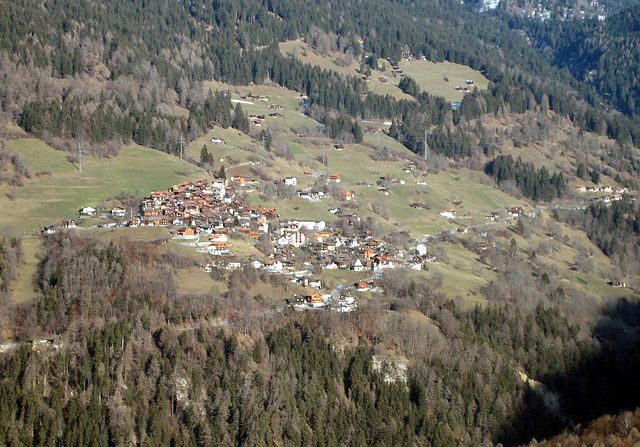
Триммис (Trimmis, Trimmis)

 Hiking in Триммис
Trimmis is a charming village located in the canton of Graubünden, Switzerland, known for its stunning landscapes and access to a variety of hiking trails. The area offers a range of hiking options that cater to different fitness levels and interests, from leisurely walks to more challenging mountain hikes.
Hiking Trails in Trimmis
-
Local Trails: There are several marked trails that start right from the village. These can vary in difficulty and length, with some leading through picturesque meadows and along streams, perfect for a family outing.
-
Scenic Views: Many trails provide breathtaking views of the surrounding mountains, valleys, and even the distant peaks of the Swiss Alps. The area is known for its natural beauty, making hikes particularly rewarding.
-
Wildlife and Flora: As you hike, keep an eye out for local wildlife and the diverse flora, which can change with the seasons. Spring and summer hikes reveal vibrant wildflowers, while autumn displays beautiful foliage.
-
Connecting Trails: Trimmis serves as a gateway to larger hiking networks in the region. You can connect to more extensive trails that lead into the nearby Flims-Laax region or the historical towns along the Rhine River.
Preparation for Hiking
-
Maps and Information: It’s advisable to carry a map or download apps that provide trail information. Local tourist offices often have resources and can offer advice on trail conditions.
-
Gear: Wear appropriate hiking boots and bring layers, as the weather can change quickly in the mountains. Don’t forget water and snacks, and consider a basic first-aid kit.
-
Safety: Always inform someone of your hiking plans, especially if you are venturing onto less-traveled paths.
Local Culture
Engaging with local culture can also enhance your hike. Check for any local events, like farmers' markets or festivals, that might be happening during your visit, allowing you to enjoy regional food and crafts.
Best Time to Hike
The best time for hiking in Trimmis typically spans from late spring to early autumn. Summer is particularly popular, though spring and fall can offer fewer crowds and a unique experience with blooming flowers or colorful foliage.
Trimmis is an excellent destination for those looking to enjoy nature, challenging themselves on trails, or simply soaking in the Swiss alpine atmosphere. Always remember to respect the environment and leave no trace to preserve the beauty for future hikers!
- Страна:

- Почтовый код: 7203
- Телефонный код: 081
- Код автомобильного номера: GR
- Координаты: 46° 53' 43" N, 9° 35' 51" E


- GPS треки (wikiloc): [Ссылка]
- Высота над уровнем моря: 1580 м m
- Площадь: 42.87 кв.км
- Население: 3283
- Веб сайт: http://www.trimmis.ch
- Википедия русская: wiki(ru)
- Википедия английская: wiki(en)
- Википедия национальная: wiki(de)
- Хранилище Wikidata: Wikidata: Q69099
- Катеория в википедии: [Ссылка]
- код Freebase: [/m/026d985]
- код GeoNames: Альт: [7287334]
- код VIAF: Альт: [239712209]
- ID отношения в OpenStreetMap: [1684191]
- место в MusicBrainz: [9b99ec30-3207-4977-bdec-0241b8402818]
- идентификатор HDS: [1601]
- код швейцарского муниципалитета: [3945]
Граничит с регионами:


Ароза
Hiking in Ароза
Arosa is a beautiful alpine resort located in Switzerland, renowned for its stunning landscapes, diverse trails, and welcoming atmosphere for hikers of all skill levels. Here’s an overview of hiking in Arosa:...
- Страна:
- Почтовый код: 7050
- Телефонный код: 081
- Код автомобильного номера: GR
- Координаты: 46° 46' 0" N, 9° 40' 1" E
- GPS треки (wikiloc): [Ссылка]
- Высота над уровнем моря: 2003 м m
- Площадь: 42.53 кв.км
- Население: 3185
- Веб сайт: [Ссылка]

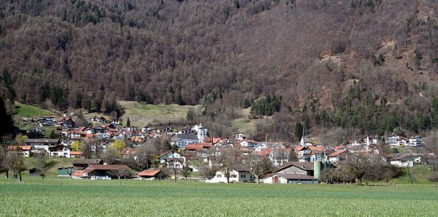
Маладерс
Hiking in Маладерс
Maladers, located near the beautiful region of Graubünden in Switzerland, is an excellent destination for hiking enthusiasts. The area offers stunning views of the surrounding mountains, lush valleys, and a variety of trails suitable for different skill levels....
- Страна:
- Почтовый код: 7026
- Телефонный код: 081
- Код автомобильного номера: GR
- Координаты: 46° 50' 41" N, 9° 34' 20" E
- GPS треки (wikiloc): [Ссылка]
- Высота над уровнем моря: 1353 м m
- Площадь: 7.59 кв.км
- Население: 505
- Веб сайт: [Ссылка]


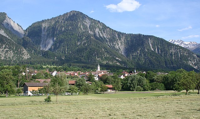
Фурна
Hiking in Фурна
Furna, located in the Swiss region of Valais, is known for its stunning landscapes and beautiful hiking trails that offer diverse terrain, from gentle slopes to challenging elevations. Here are some key points about hiking in Furna:...
- Страна:
- Почтовый код: 7232
- Телефонный код: 081
- Код автомобильного номера: GR
- Координаты: 46° 55' 31" N, 9° 39' 49" E
- GPS треки (wikiloc): [Ссылка]
- Высота над уровнем моря: 1412 м m
- Площадь: 33.32 кв.км
- Население: 213
- Веб сайт: [Ссылка]


Хальденштайн
Hiking in Хальденштайн
Haldenstein, located in the canton of Graubünden in Switzerland, is an excellent destination for hiking enthusiasts. The area is known for its stunning landscapes, picturesque views, and a variety of hiking trails that cater to different skill levels....
- Страна:
- Почтовый код: 7023
- Телефонный код: 081
- Код автомобильного номера: GR
- Координаты: 46° 52' 43" N, 9° 31' 37" E
- GPS треки (wikiloc): [Ссылка]
- Высота над уровнем моря: 1557 м m
- Площадь: 18.56 кв.км
- Население: 1025
- Веб сайт: [Ссылка]


Кур
- община в Швейцарии, Граубюнден
Hiking in Кур
Chur, the capital of the Graubünden canton in Switzerland, offers a fantastic array of hiking opportunities. Nestled in the heart of the Alps, it boasts stunning landscapes that attract both beginner and experienced hikers. Here are some key highlights about hiking in and around Chur:...
- Страна:
- Почтовый код: 6969
- Телефонный код: 081
- Код автомобильного номера: GR
- Координаты: 46° 51' 8" N, 9° 31' 47" E
- GPS треки (wikiloc): [Ссылка]
- Высота над уровнем моря: 593 м m
- Площадь: 28.09 кв.км
- Население: 35038
- Веб сайт: [Ссылка]

Унтервац
Hiking in Унтервац
Untervaz is a picturesque village located in the Canton of Graubünden in Switzerland, known for its stunning landscapes, lush nature, and diverse hiking trails. Here are some key points about hiking in Untervaz:...
- Страна:
- Почтовый код: 7204
- Телефонный код: 081
- Код автомобильного номера: GR
- Координаты: 46° 55' 14" N, 9° 30' 57" E
- GPS треки (wikiloc): [Ссылка]
- Высота над уровнем моря: 1145 м m
- Площадь: 27.72 кв.км
- Население: 2512
- Веб сайт: [Ссылка]

Цицерс
Hiking in Цицерс
Zizers, located in the Canton of Graubünden in Switzerland, is a beautiful destination for hiking enthusiasts. The region boasts stunning landscapes, offering a mix of lush valleys, alpine meadows, and impressive mountain vistas. Here are some highlights and tips for hiking in and around Zizers:...
- Страна:
- Почтовый код: 7205
- Телефонный код: 081
- Код автомобильного номера: GR
- Координаты: 46° 56' 11" N, 9° 34' 15" E
- GPS треки (wikiloc): [Ссылка]
- Высота над уровнем моря: 606 м m
- Площадь: 11.01 кв.км
- Население: 3443
- Веб сайт: [Ссылка]