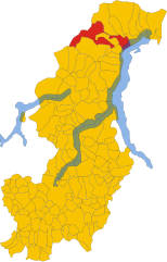
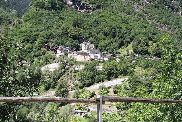
Сан-Витторе (San Vittore, San Vittore)

 Hiking in Сан-Витторе
San Vittore, located in the canton of Graubünden in Switzerland, offers a variety of hiking opportunities amidst stunning alpine scenery. Here’s an overview of what to expect when hiking in this beautiful region:
Scenic Trails
San Vittore is close to the Valtellina valley, known for its breathtaking landscapes, including rolling hills, lush forests, and impressive mountain views. You can find a range of trails that cater to different skill levels, from easy walks suitable for families to more challenging hikes for experienced trekkers.
Popular Hiking Routes
- Panorama Trail: This trail offers stunning views of the surrounding mountains and valleys. Depending on the route, it can take several hours and is suitable for intermediates.
- Val da Camp: A longer hike that takes you through beautiful valleys and picturesque landscapes. It’s ideal for those looking for a full-day hiking experience.
- Local Trails: Explore smaller local paths that lead to hidden gems, such as lakes and streams, perfect for a tranquil hiking experience.
Flora and Fauna
Hikers can enjoy diverse flora, including lush alpine meadows in the summer, as well as opportunities to spot wildlife such as chamois, marmots, and various bird species. The area is rich in biodiversity, making each hike a potential adventure in wildlife watching.
Access and Facilities
San Vittore is accessible by public transportation, including buses that connect to various trailheads in the region. There are also local mountain huts and restaurants where you can rest and enjoy traditional Swiss food. Be sure to check opening times in advance, especially in off-peak seasons.
Best Time to Hike
The best time for hiking in the San Vittore region is from late spring to early fall (May to October) when trails are typically clear of snow. Early fall also offers beautiful autumn colors, making it an excellent time for photography.
Safety Tips
- Preparation: Always check the weather before heading out, and be prepared for changing conditions in the mountains.
- Gear: Wear appropriate hiking gear, including sturdy hiking boots, weather-resistant clothing, and a hat or sunscreen.
- Navigation: Carry a map or GPS device, as some trails may not be well-marked.
- Hydrate: Bring sufficient water and snacks to stay energized during your hike.
Conclusion
Whether you're looking for a leisurely stroll or a day-long trek, hiking in San Vittore offers an opportunity to immerse yourself in the breathtaking natural beauty of Switzerland. Don’t forget to take your camera to capture the stunning scenery!
- Страна:

- Почтовый код: 6534
- Телефонный код: 091
- Код автомобильного номера: GR
- Координаты: 46° 14' 17" N, 9° 6' 22" E


- GPS треки (wikiloc): [Ссылка]
- Высота над уровнем моря: 688 м m
- Площадь: 22.06 кв.км
- Население: 825
- Веб сайт: http://sanvittore.moesano.ch
- Википедия русская: wiki(ru)
- Википедия английская: wiki(en)
- Википедия национальная: wiki(de)
- Хранилище Wikidata: Wikidata: Q65687
- Катеория в википедии: [Ссылка]
- код Freebase: [/m/026gpmt]
- код GeoNames: Альт: [7287052]
- код VIAF: Альт: [248211500]
- ID отношения в OpenStreetMap: [1684152]
- код GND: Альт: [1064606776]
- идентификатор местоположения ArchINFORM: [9376]
- идентификатор HDS: [1563]
- код швейцарского муниципалитета: [3835]
Граничит с регионами:

Gravedona ed Uniti
- коммуна Италии
Hiking in Gravedona ed Uniti
Gravedona ed Uniti is a charming town located on the northern shores of Lake Como in Italy, known for its beautiful landscapes and rich history. Hiking in this area offers a variety of trails that cater to different skill levels, providing stunning views of the lake, surrounding mountains, and picturesque villages....
- Страна:

- Почтовый код: 22015
- Телефонный код: 0344
- Код автомобильного номера: CO
- Координаты: 46° 9' 0" N, 9° 18' 0" E
- GPS треки (wikiloc): [Ссылка]
- Высота над уровнем моря: 201 м m
- Площадь: 39.85 кв.км
- Население: 4198
- Веб сайт: [Ссылка]


Ровередо
Hiking in Ровередо
Roveredo is a quaint town located in the Mendrisiotto region of Ticino, Switzerland. Surrounded by stunning natural landscapes, it offers several hiking opportunities that cater to a variety of skill levels. Here are some highlights of hiking in Roveredo:...
- Страна:
- Почтовый код: 6535
- Телефонный код: 091
- Код автомобильного номера: GR
- Координаты: 46° 14' 5" N, 9° 7' 33" E
- GPS треки (wikiloc): [Ссылка]
- Высота над уровнем моря: 1239 м m
- Площадь: 38.79 кв.км
- Население: 2483
- Веб сайт: [Ссылка]

Бузено
Hiking in Бузено
Buseno is a small, picturesque village located in the southern part of Switzerland, particularly in the canton of Graubünden. It's known for its stunning landscapes, mountainous terrain, and tranquil atmosphere, making it an excellent destination for hiking enthusiasts....
- Страна:
- Почтовый код: 6542
- Телефонный код: 091
- Код автомобильного номера: GR
- Координаты: 46° 16' 23" N, 9° 6' 26" E
- GPS треки (wikiloc): [Ссылка]
- Высота над уровнем моря: 801 м m
- Площадь: 11.15 кв.км
- Население: 83
- Веб сайт: [Ссылка]


Кастанеда
Hiking in Кастанеда
Castaneda, located in the Swiss canton of Graubünden, is a lesser-known gem for hikers seeking both beauty and tranquility. The region is characterized by stunning landscapes, including alpine meadows, picturesque valleys, and majestic mountain views. Here are a few highlights for hiking in Castaneda:...
- Страна:
- Почтовый код: 6540
- Телефонный код: 091
- Код автомобильного номера: GR
- Координаты: 46° 14' 59" N, 9° 7' 59" E
- GPS треки (wikiloc): [Ссылка]
- Высота над уровнем моря: 750 м m
- Площадь: 3.96 кв.км
- Население: 277
- Веб сайт: [Ссылка]


Арвиго
Hiking in Арвиго
Arvigo, a picturesque village in the canton of Graubünden, Switzerland, is known for its stunning landscapes and outdoor activities, making it a great destination for hiking enthusiasts. The area offers a variety of trails that cater to different skill levels, from easy walks to more challenging hikes....
- Страна:
- Почтовый код: 6543
- Телефонный код: 091
- Код автомобильного номера: GR
- Координаты: 46° 18' 7" N, 9° 6' 45" E
- GPS треки (wikiloc): [Ссылка]
- Высота над уровнем моря: 872 м m
- Площадь: 17.01 кв.км
- Веб сайт: [Ссылка]


Lumino
Hiking in Lumino
Lumino is a picturesque village located in the Canton of Ticino, Switzerland, known for its beautiful landscapes and hiking opportunities. The region offers a range of trails suitable for different skill levels, from easy walks to more challenging hikes....
- Страна:
- Почтовый код: 6533
- Телефонный код: 091
- Код автомобильного номера: TI
- Координаты: 46° 14' 18" N, 9° 4' 5" E
- GPS треки (wikiloc): [Ссылка]
- Высота над уровнем моря: 483 м m
- Площадь: 9.92 кв.км
- Население: 1470
- Веб сайт: [Ссылка]
Cresciano
Hiking in Cresciano
Cresciano, located in the scenic Ticino region of Switzerland, offers a variety of hiking opportunities characterized by beautiful landscapes, charming villages, and rich natural diversity. Here are some highlights and tips for hiking in Cresciano:...
- Страна:
- Почтовый код: 6705
- Телефонный код: 091
- Код автомобильного номера: TI
- Координаты: 46° 18' 12" N, 9° 1' 59" E
- GPS треки (wikiloc): [Ссылка]
- Высота над уровнем моря: 1655 м m
- Площадь: 17.19 кв.км
- Веб сайт: [Ссылка]


Claro
Hiking in Claro
Claro, a picturesque village in the southern part of Switzerland, is nestled in the Ticino region, a gem for hikers and outdoor enthusiasts. The region offers a variety of trails that highlight its stunning landscapes, diverse flora, and charming valleys. Here are some key aspects to consider when hiking in Claro:...
- Страна:
- Почтовый код: 6702
- Телефонный код: 091
- Код автомобильного номера: TI
- Координаты: 46° 15' 58" N, 9° 2' 12" E
- GPS треки (wikiloc): [Ссылка]
- Высота над уровнем моря: 989 м m
- Площадь: 21.22 кв.км
- Веб сайт: [Ссылка]