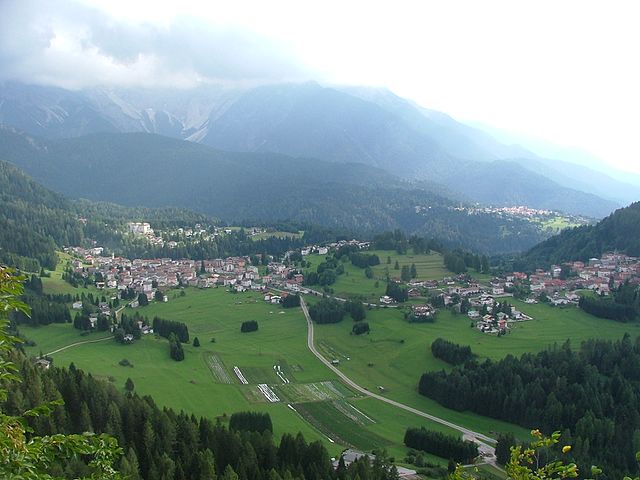
Прато-Карнико (Prato Carnico, Prato Carnico)
.svg)
- коммуна Италии
 Hiking in Прато-Карнико
Prato Carnico is a beautiful alpine village located in the Friuli Venezia Giulia region of northeastern Italy. It's set in the Carnic Alps, offering stunning natural landscapes that are perfect for hiking enthusiasts. Here are some highlights and tips for hiking in the Prato Carnico area:
Trails
-
Sentiero della Fauna: This trail showcases the rich biodiversity of the area and allows hikers to observe various local wildlife. It's moderately challenging and suitable for families.
-
Forcella di Monte Crostis: This is a more challenging hike that offers breathtaking views of the surrounding peaks, including Monte Crostis itself. It's recommended for experienced hikers.
-
Valle del Fella: A picturesque valley offering gentler trails that are great for day hikes. This area provides opportunities to discover local flora and fauna while enjoying stunning views.
-
Alpe di Sús: An excellent circuit which not only offers beautiful views but also takes you through charming alpine pastures and rugged landscapes.
Best Time to Hike
The best time for hiking in Prato Carnico is late spring through early autumn (May to October), when the weather is generally stable, and the trails are in good condition. Summer months can get quite warm, while early autumn can offer crisp air and beautiful fall foliage.
Preparation
-
Gear: Due to variable weather conditions, proper hiking boots, layered clothing, and rain gear are essential. A good backpack, hydration system, and snacks are also important.
-
Maps and Guides: Make sure you have updated maps of the trails. It can be beneficial to have a guidebook or hire a local guide to learn more about the area.
-
Safety: Always inform someone about your hiking plans and expected return time. Be aware of your physical limits and take breaks as needed.
Local Attractions
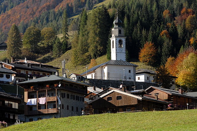
Besides hiking, Prato Carnico offers a glimpse into traditional mountain life, with historic buildings and local culture. Consider visiting nearby towns, exploring local cuisine, and possibly combining hikes with other outdoor activities like mountain biking or bird-watching.
Overall, Prato Carnico is a wonderful destination for hikers seeking both adventure and the beauty of the alpine landscape. Enjoy your hiking adventures!
- Страна:

- Почтовый код: 33020
- Телефонный код: 0433
- Код автомобильного номера: UD
- Координаты: 46° 31' 0" N, 12° 49' 0" E


- GPS треки (wikiloc): [Ссылка]
- Высота над уровнем моря: 686 м m
- Площадь: 81.72 кв.км
- Население: 898
- Веб сайт: http://www.comune.prato.bz.it
- Википедия русская: wiki(ru)
- Википедия английская: wiki(en)
- Википедия национальная: wiki(it)
- Хранилище Wikidata: Wikidata: Q53316
- Катеория в википедии: [Ссылка]
- код Freebase: [/m/0gk9q1]
- код GeoNames: Альт: [6536251]
- код VIAF: Альт: [147828099]
- ID отношения в OpenStreetMap: [79226]
- код ISTAT: 030081
- кадастровый код Италии: H002
Граничит с регионами:

Виго-ди-Кадоре
- коммуна Италии
Hiking in Виго-ди-Кадоре
Vigo di Cadore is a picturesque village in the Dolomites, located in the Veneto region of Italy. It’s an excellent starting point for hiking enthusiasts due to its stunning landscapes, diverse trails, and rich natural and cultural heritage. Here are some highlights about hiking in Vigo di Cadore:...
- Страна:
- Почтовый код: 32040
- Телефонный код: 0435
- Код автомобильного номера: BL
- Координаты: 46° 30' 0" N, 12° 28' 0" E
- GPS треки (wikiloc): [Ссылка]
- Высота над уровнем моря: 947 м m
- Площадь: 70.07 кв.км
- Население: 1409
- Веб сайт: [Ссылка]


Комельянс
- коммуна Италии
Hiking in Комельянс
Comeglians is a charming village located in the Friuli Venezia Giulia region of northeastern Italy, nestled in the heart of the Carnic Alps. The area is ideal for hiking enthusiasts, offering a variety of trails that cater to different skill levels and preferences. Here’s a breakdown of what you can expect when hiking in Comeglians:...
- Страна:
- Почтовый код: 33023
- Телефонный код: 0433
- Код автомобильного номера: UD
- Координаты: 46° 31' 0" N, 12° 53' 0" E
- GPS треки (wikiloc): [Ссылка]
- Высота над уровнем моря: 553 м m
- Площадь: 19.41 кв.км
- Население: 491
- Веб сайт: [Ссылка]


Форни-Авольтри
- коммуна Италии
Hiking in Форни-Авольтри
Forni Avoltri is a charming village located in the Friuli Venezia Giulia region of northeastern Italy, surrounded by the stunning landscapes of the Carnic Alps. The area is well-known for its beautiful hiking trails, which cater to a variety of skill levels, from beginners to more experienced hikers....
- Страна:
- Почтовый код: 33020
- Телефонный код: 0433
- Код автомобильного номера: UD
- Координаты: 46° 35' 0" N, 12° 47' 0" E
- GPS треки (wikiloc): [Ссылка]
- Высота над уровнем моря: 888 м m
- Площадь: 80.75 кв.км
- Население: 562
- Веб сайт: [Ссылка]

Оваро
- коммуна Италии
Hiking in Оваро
Ovaro is a beautiful town located in the Friuli Venezia Giulia region of northeastern Italy. It's situated in the Carnic Alps and is surrounded by stunning natural landscapes, making it a great destination for hiking enthusiasts. Here are some key points to consider when hiking in and around Ovaro:...
- Страна:
- Почтовый код: 33025
- Телефонный код: 0433
- Код автомобильного номера: UD
- Координаты: 46° 29' 0" N, 12° 52' 0" E
- GPS треки (wikiloc): [Ссылка]
- Высота над уровнем моря: 525 м m
- Площадь: 57.9 кв.км
- Население: 1875
- Веб сайт: [Ссылка]


Риголато
- коммуна Италии
Hiking in Риголато
Rigolato is a charming village located in the Friuli Venezia Giulia region of northeastern Italy. It sits in the heart of the Carnic Alps, making it a fantastic destination for hiking enthusiasts. Here are some highlights and tips for hiking in Rigolato:...
- Страна:
- Почтовый код: 33020
- Телефонный код: 0433
- Код автомобильного номера: UD
- Координаты: 46° 33' 0" N, 12° 51' 0" E
- GPS треки (wikiloc): [Ссылка]
- Высота над уровнем моря: 760 м m
- Площадь: 30.77 кв.км
- Население: 428
- Веб сайт: [Ссылка]

Саурис
- коммуна Италии
Hiking in Саурис
Sauris, a picturesque village located in the Friuli Venezia Giulia region of Italy, is a hidden gem for hikers. Nestled in the Julian Alps, it offers stunning landscapes, rich cultural heritage, and an array of hiking trails suitable for various experience levels....
- Страна:
- Почтовый код: 33020
- Телефонный код: 0433
- Код автомобильного номера: UD
- Координаты: 46° 27' 58" N, 12° 42' 31" E
- GPS треки (wikiloc): [Ссылка]
- Высота над уровнем моря: 1212 м m
- Площадь: 41.49 кв.км
- Население: 405
- Веб сайт: [Ссылка]