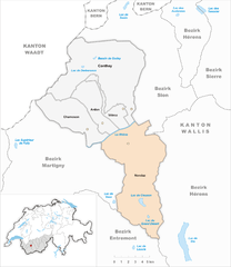
Conthey District (Bezirk Conthey)

 Hiking in Conthey District
Conthey District, located in the Canton of Valais in Switzerland, is known for its stunning landscapes, abundant natural beauty, and diverse hiking opportunities. Here are some highlights of hiking in this area:
Scenic Trails
-
The Rhone Valley: The trails along the Rhone River offer beautiful views of the valley and the surrounding mountains. This is a relatively easy hike, suitable for families and beginners.
-
Bisse de Chervé: This historic irrigation canal trail is a must-do. The path runs through stunning landscapes, and the walk offers a glimpse into the region's agricultural heritage.
-
Visp - Conthey Hike: This moderate trail connects Visp to the village of Conthey, featuring beautiful vineyards and stunning alpine views along the way.
-
Hikes to the surrounding peaks: Numerous trails lead to nearby summits like the Dent de Morcle and Grand Bec, offering more challenging treks with breathtaking views.
Difficulty Levels
Conthey District offers a variety of hikes suitable for different skill levels, from easy walks through the valley to challenging ascents that require proper equipment and experience.
Tips for Hiking in Conthey District
- Best time to hike: Late spring to early autumn, generally from May to October, is the best time for hiking, as trails are accessible and weather conditions are favorable.
- Weather: Always check the local weather forecast before setting out, as conditions in the mountains can change rapidly.
- Local Amenities: Ensure to have access to map resources, and stay hydrated. There are several points of interest along the trails where you can rest and enjoy local cuisine.
Gear Recommendations
- Proper Footwear: Wear ankle-supporting hiking boots to navigate varied terrain comfortably.
- Clothing Layers: Dress in layers to adapt to changing weather conditions.
- Safety Gear: A first aid kit, a whistle, and navigation tools (GPS or a physical map) are essential.
Local Events
If you are visiting during the summer months, consider looking for local hiking groups or guided tours to enhance your experience and learn more about the region's ecology and culture.
Enjoy your hiking adventure in Conthey District!
- Страна:

- Столица: Conthey
- Код автомобильного номера: VS
- Координаты: 46° 12' 17" N, 7° 16' 42" E


- GPS треки (wikiloc): [Ссылка]
- Высота над уровнем моря: 487 м m
- Площадь: 234.2 кв.км
- Википедия английская: wiki(en)
- Википедия национальная: wiki(de)
- Хранилище Wikidata: Wikidata: Q660562
- Катеория в википедии: [Ссылка]
- код Freebase: [/m/0dz8bx]
- код GeoNames: Альт: [6458850]
- идентификатор местоположения ArchINFORM: [45096]
- идентификатор HDS: [8406]
Включает регионы:


Vétroz
Hiking in Vétroz
Vétroz is a picturesque village located in the Valais region of Switzerland, at the foot of the Alps. The area offers a variety of hiking opportunities for all skill levels, from leisurely strolls to more challenging routes. Here are some highlights for hiking in Vétroz:...
- Страна:
- Почтовый код: 1963
- Телефонный код: 027
- Код автомобильного номера: VS
- Координаты: 46° 13' 33" N, 7° 16' 14" E
- GPS треки (wikiloc): [Ссылка]
- Высота над уровнем моря: 573 м m
- Площадь: 10.4 кв.км
- Население: 6268
- Веб сайт: [Ссылка]

Nendaz
Hiking in Nendaz
Nendaz is a picturesque resort located in the Valais region of Switzerland, renowned for its stunning landscapes and extensive network of hiking trails. With its breathtaking views of the magnificent Swiss Alps and its rich flora and fauna, Nendaz is an excellent destination for both casual hikers and experienced trekkers....
- Страна:
- Почтовый код: 1993, 1994, 1996, 1997
- Телефонный код: 027
- Код автомобильного номера: VS
- Координаты: 46° 11' 0" N, 7° 18' 0" E
- GPS треки (wikiloc): [Ссылка]
- Высота над уровнем моря: 1252 м m
- Площадь: 85.9 кв.км
- Население: 6595
- Веб сайт: [Ссылка]


Ardon
- община Швейцарии
Hiking in Ardon
Ardon, located in the Valais region of Switzerland, is surrounded by stunning landscapes and offers a variety of hiking opportunities for all levels of hikers. Here are some highlights of hiking in and around Ardon:...
- Страна:
- Телефонный код: 027
- Код автомобильного номера: VS
- Координаты: 46° 12' 0" N, 7° 15' 0" E
- GPS треки (wikiloc): [Ссылка]
- Высота над уровнем моря: 503 м m
- Площадь: 20.4 кв.км
- Население: 3137
- Веб сайт: [Ссылка]


Conthey
Hiking in Conthey
Conthey is a charming municipality located in the Valais region of Switzerland, known for its stunning landscapes, rich cultural heritage, and various outdoor activities, including hiking. Here are some key points to consider when hiking in and around Conthey:...
- Страна:
- Почтовый код: 1964
- Телефонный код: 027
- Код автомобильного номера: VS
- Координаты: 46° 16' 21" N, 7° 15' 17" E
- GPS треки (wikiloc): [Ссылка]
- Высота над уровнем моря: 1824 м m
- Площадь: 85.1 кв.км
- Население: 8691
- Веб сайт: [Ссылка]


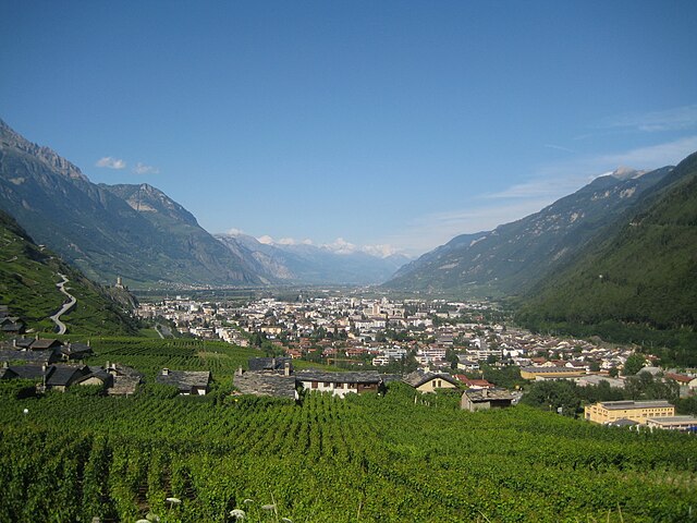
Chamoson
Hiking in Chamoson
Chamoson is a charming municipality located in the Valais region of Switzerland, known for its picturesque landscapes, vineyards, and proximity to the Alps. Hiking in Chamoson offers a variety of trails suitable for different experience levels, providing stunning views of the Rhone Valley and surrounding peaks....
- Страна:
- Телефонный код: 027
- Код автомобильного номера: VS
- Координаты: 46° 12' 0" N, 7° 13' 0" E
- GPS треки (wikiloc): [Ссылка]
- Высота над уровнем моря: 490 м m
- Площадь: 32.4 кв.км
- Население: 3787
- Веб сайт: [Ссылка]
Граничит с регионами:
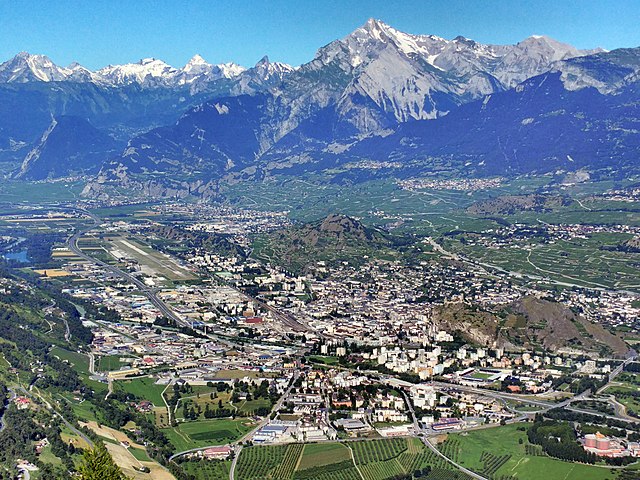

Sion District
Hiking in Sion District
The Sion District, located in the heart of Switzerland's Valais canton, is a wonderful destination for hiking enthusiasts. Known for its stunning alpine landscapes, charming villages, and rich cultural heritage, the Sion District offers a variety of hiking trails suitable for different skill levels....
- Страна:
- Столица: Сьон
- Код автомобильного номера: VS
- Координаты: 46° 14' 0" N, 7° 20' 58" E
- GPS треки (wikiloc): [Ссылка]
- Высота над уровнем моря: 548 м m
- Площадь: 125.6 кв.км


Hérens District
Hiking in Hérens District
The Hérens District, located in the Valais Canton of Switzerland, is known for its stunning landscapes, diverse terrain, and rich cultural heritage, making it a fantastic destination for hiking enthusiasts. Here are some key points to consider when hiking in the Hérens District:...
- Страна:
- Столица: Vex
- Код автомобильного номера: VS
- Координаты: 46° 11' 38" N, 7° 25' 26" E
- GPS треки (wikiloc): [Ссылка]
- Высота над уровнем моря: 1098 м m
- Площадь: 443.5 кв.км

Martigny District
Hiking in Martigny District
Hiking in the Martigny District can be a breathtaking experience, as it is located in the Valais region of Switzerland, known for its stunning landscapes, varied terrain, and rich cultural history. Here are some highlights and tips for hiking in this area:...
- Страна:
- Столица: Мартиньи
- Код автомобильного номера: VS
- Координаты: 46° 7' 26" N, 7° 6' 13" E
- GPS треки (wikiloc): [Ссылка]
- Высота над уровнем моря: 458 м m
- Площадь: 263.5 кв.км


Entremont District
Hiking in Entremont District
The Entremont District, located in the French Alps, is a fantastic destination for hiking enthusiasts, offering stunning landscapes and a variety of trails for all levels of hikers. The region is characterized by its alpine scenery, including majestic mountains, lush valleys, and picturesque villages, making it a great place to explore the natural beauty of the French Alps....
- Страна:
- Столица: Sembrancher
- Код автомобильного номера: VS
- Координаты: 46° 3' 42" N, 7° 16' 23" E
- GPS треки (wikiloc): [Ссылка]
- Высота над уровнем моря: 2229 м m
- Площадь: 633.2 кв.км