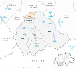
Entremont District (Bezirk Entremont)

 Hiking in Entremont District
The Entremont District, located in the French Alps, is a fantastic destination for hiking enthusiasts, offering stunning landscapes and a variety of trails for all levels of hikers. The region is characterized by its alpine scenery, including majestic mountains, lush valleys, and picturesque villages, making it a great place to explore the natural beauty of the French Alps.
Hiking Highlights:
-
Diverse Trails: The Entremont District features a variety of trails ranging from easy, family-friendly paths to challenging mountain routes. Whether you’re looking for a leisurely stroll or a more strenuous adventure, there’s something for everyone.
-
Stunning Views: Many of the hiking trails offer breathtaking panoramic views of the surrounding alpine peaks, including the Mont Blanc massif. The changing landscapes with each season (wildflowers in spring, vibrant fall colors) make it a year-round hiking destination.
-
Flora and Fauna: As you hike, you may encounter diverse wildlife and a variety of plant species. Keep an eye out for ibex, chamois, and various bird species. The region is rich in biodiversity, especially in protected areas.
-
Accessibility: The trails are generally well-marked and accessible from various points, making it easy to plan your hikes based on your skill level and desired duration. Many trails also connect to nearby villages where you can rest and enjoy local cuisine.
-
Cultural Experience: Hiking in the Entremont District also allows you to immerse yourself in the local culture. Stop by small alpine villages, experience traditional French mountain hospitality, and sample local cheeses and wines.
Popular Hiking Routes:
-
Col de la Dent: A moderately challenging hike that provides stunning views of the surrounding peaks and is suitable for experienced hikers.
-
Lacs de la Tempête: An easier route that leads to beautiful alpine lakes, making it perfect for families or those looking for a shorter hike.
-
Tour du Mont Blanc: Though not exclusively in the Entremont District, segments of this famous long-distance trail can be accessed from the area. It's a great option for those looking to take on a multi-day adventure.
Tips for Hiking in Entremont District:
-
Preparation: Always check the weather forecast and trail conditions before heading out. The alpine weather can change quickly, and it’s essential to be prepared for various conditions.
-
Equipment: Wear appropriate hiking boots and clothing, and don’t forget to pack essentials such as water, snacks, a map, and a first aid kit.
-
Leave No Trace: Respect the environment by following Leave No Trace principles—stay on marked trails and avoid disturbing wildlife.
-
Safety: If you're venturing into high-altitude areas, be aware of altitude sickness and know how to recognize the symptoms.
With its incredible scenery and rich biodiversity, the Entremont District is a remarkable destination for hiking enthusiasts looking to explore the beauty of the French Alps. Enjoy your adventure!
- Страна:

- Столица: Sembrancher
- Код автомобильного номера: VS
- Координаты: 46° 3' 42" N, 7° 16' 23" E


- GPS треки (wikiloc): [Ссылка]
- Высота над уровнем моря: 2229 м m
- Площадь: 633.2 кв.км
- Википедия английская: wiki(en)
- Википедия национальная: wiki(de)
- Хранилище Wikidata: Wikidata: Q660495
- Катеория в википедии: [Ссылка]
- код Freebase: [/m/0273bw5]
- код GeoNames: Альт: [6458768]
- код BNF: [122273539]
- идентификатор местоположения ArchINFORM: [45098]
- идентификатор HDS: [8395]
- код BabelNet: [03724545n]
Включает регионы:


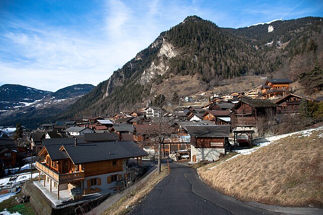
Liddes
Hiking in Liddes
Liddes is a picturesque area located in the Val d'Entremont in the Swiss Alps, known for its beautiful landscapes, charming villages, and extensive hiking opportunities. Here are some points to consider if you're planning a hiking trip in Liddes:...
- Страна:
- Почтовый код: 1945
- Телефонный код: 027
- Код автомобильного номера: VS
- Координаты: 45° 59' 0" N, 7° 11' 0" E
- GPS треки (wikiloc): [Ссылка]
- Высота над уровнем моря: 1380 м m
- Площадь: 60.2 кв.км
- Население: 767
- Веб сайт: [Ссылка]

Bagnes
Hiking in Bagnes
Bagnes, located in the Valais region of Switzerland, is a spectacular destination for hikers, offering a variety of trails that cater to different skill levels. The region is known for its stunning alpine scenery, including dramatic mountain peaks, lush valleys, and picturesque villages....
- Страна:
- Почтовый код: 1934
- Телефонный код: 027
- Код автомобильного номера: VS
- Координаты: 46° 5' 0" N, 7° 13' 0" E
- GPS треки (wikiloc): [Ссылка]
- Высота над уровнем моря: 924 м m
- Площадь: 282.2 кв.км
- Население: 8100
- Веб сайт: [Ссылка]

Vollèges
Hiking in Vollèges
Vollèges is a picturesque area located in the Swiss Alps, in the Valais canton, near the larger city of Martigny. The region is known for its stunning landscapes, diverse flora and fauna, and well-maintained hiking trails that cater to various skill levels. Here are some key points to consider when hiking in Vollèges:...
- Страна:
- Почтовый код: 1941
- Телефонный код: 027
- Код автомобильного номера: VS
- Координаты: 46° 5' 0" N, 7° 10' 0" E
- GPS треки (wikiloc): [Ссылка]
- Высота над уровнем моря: 843 м m
- Площадь: 17.9 кв.км
- Население: 2001
- Веб сайт: [Ссылка]


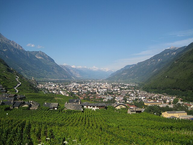
Sembrancher
Hiking in Sembrancher
Sembrancher, a charming village located in the Val de Bagnes region of Switzerland, offers excellent hiking opportunities for outdoor enthusiasts. The area is known for its breathtaking alpine scenery, lush forests, and tranquil mountain lakes, making it a prime destination for both casual walkers and experienced hikers....
- Страна:
- Почтовый код: 1933
- Телефонный код: 027
- Код автомобильного номера: VS
- Координаты: 46° 4' 41" N, 7° 9' 4" E
- GPS треки (wikiloc): [Ссылка]
- Высота над уровнем моря: 928 м m
- Площадь: 17.7 кв.км
- Население: 1034
- Веб сайт: [Ссылка]


Bourg-Saint-Pierre
Hiking in Bourg-Saint-Pierre
Bourg-Saint-Pierre is a picturesque village located in the Swiss Alps, nestled in the Valais Canton. It serves as a fantastic base for hiking enthusiasts due to its stunning landscapes and diverse trails. Here are some highlights about hiking in the area:...
- Страна:
- Почтовый код: 1946
- Телефонный код: 027
- Код автомобильного номера: VS
- Координаты: 45° 57' 0" N, 7° 12' 0" E
- GPS треки (wikiloc): [Ссылка]
- Высота над уровнем моря: 1623 м m
- Площадь: 90.2 кв.км
- Население: 181


Orsières
Hiking in Orsières
Orsières is a charming municipality located in the Valais region of Switzerland, surrounded by stunning alpine scenery, making it a great destination for hiking enthusiasts. Here are some key points to consider if you plan to hike in Orsières:...
- Страна:
- Почтовый код: 1937
- Телефонный код: 027
- Код автомобильного номера: VS
- Координаты: 45° 58' 20" N, 7° 6' 6" E
- GPS треки (wikiloc): [Ссылка]
- Высота над уровнем моря: 1897 м m
- Площадь: 165.0 кв.км
- Население: 3190
- Веб сайт: [Ссылка]
Граничит с регионами:


Hérens District
Hiking in Hérens District
The Hérens District, located in the Valais Canton of Switzerland, is known for its stunning landscapes, diverse terrain, and rich cultural heritage, making it a fantastic destination for hiking enthusiasts. Here are some key points to consider when hiking in the Hérens District:...
- Страна:
- Столица: Vex
- Код автомобильного номера: VS
- Координаты: 46° 11' 38" N, 7° 25' 26" E
- GPS треки (wikiloc): [Ссылка]
- Высота над уровнем моря: 1098 м m
- Площадь: 443.5 кв.км

Martigny District
Hiking in Martigny District
Hiking in the Martigny District can be a breathtaking experience, as it is located in the Valais region of Switzerland, known for its stunning landscapes, varied terrain, and rich cultural history. Here are some highlights and tips for hiking in this area:...
- Страна:
- Столица: Мартиньи
- Код автомобильного номера: VS
- Координаты: 46° 7' 26" N, 7° 6' 13" E
- GPS треки (wikiloc): [Ссылка]
- Высота над уровнем моря: 458 м m
- Площадь: 263.5 кв.км

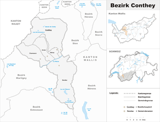
Conthey District
Hiking in Conthey District
Conthey District, located in the Canton of Valais in Switzerland, is known for its stunning landscapes, abundant natural beauty, and diverse hiking opportunities. Here are some highlights of hiking in this area:...
- Страна:
- Столица: Conthey
- Код автомобильного номера: VS
- Координаты: 46° 12' 17" N, 7° 16' 42" E
- GPS треки (wikiloc): [Ссылка]
- Высота над уровнем моря: 487 м m
- Площадь: 234.2 кв.км