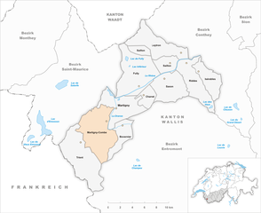
Martigny District (Bezirk Martigny)

 Hiking in Martigny District
Hiking in the Martigny District can be a breathtaking experience, as it is located in the Valais region of Switzerland, known for its stunning landscapes, varied terrain, and rich cultural history. Here are some highlights and tips for hiking in this area:
Scenic Landscapes
- Mountain Ranges: The district is surrounded by the majestic Alps, providing spectacular views of peaks like the Mont Blanc massif and the Dents du Midi.
- Lakes: There are numerous pristine lakes nearby, including Lake Champex and Lake Emosson, which make for beautiful hiking destinations.
- Forests and Valleys: The region is dotted with lush forests and picturesque valleys, offering a variety of ecosystems to explore.
Popular Hiking Trails
- Chemin de l'Inner UV: This trail offers an easy to moderate trek with beautiful views and cultural landmarks along the way.
- Col de la Forclaz: A stunning route that combines beautiful alpine scenery with access to various other hiking paths.
- Grand Combin and Mont Fort: For more experienced hikers, trails in the vicinity of these peaks offer challenging routes with rewarding views.
Difficulty Levels
- The Martigny District has a range of hiking trails suitable for all levels, from easy walks to challenging mountain hikes. Be sure to check local resources for trail difficulty ratings and conditions.
Facilities and Safety
- Trail Markings: Most trails are well-marked, but it is advisable to carry a detailed map or a GPS device.
- Huts and Cabins: There are several mountain huts offering food and accommodation, perfect for longer hikes.
- Weather Conditions: The weather can change rapidly in mountainous areas, so it is essential to check forecasts and be prepared for varying conditions.
Local Tips
- Best Time to Hike: The ideal hiking season usually spans from late spring to early autumn (May to October), depending on the altitude.
- Wildlife: Keep an eye out for local wildlife and enjoy the diverse flora along the trails.
- Cultural Experience: Take time to explore charming villages like Martigny and Chamonix, rich in history, and local cuisine.
Getting There
- Public Transport: Martigny is accessible by train, making it easy to reach various hiking trailheads.
- Car Access: If driving, plenty of parking options exist at the trailheads.
Whether you're a seasoned hiker or just beginning, the Martigny District offers something for everyone, with its impressive natural beauty and trails to suit all abilities. Always remember to follow local regulations and practice Leave No Trace principles to help preserve this beautiful environment. Happy hiking!
- Страна:

- Столица: Мартиньи
- Код автомобильного номера: VS
- Координаты: 46° 7' 26" N, 7° 6' 13" E


- GPS треки (wikiloc): [Ссылка]
- Высота над уровнем моря: 458 м m
- Площадь: 263.5 кв.км
- Википедия английская: wiki(en)
- Википедия национальная: wiki(de)
- Хранилище Wikidata: Wikidata: Q656949
- Катеория в википедии: [Ссылка]
- код Freebase: [/m/0273bvh]
- код GeoNames: Альт: [2659752]
- идентификатор местоположения ArchINFORM: [45099]
- идентификатор HDS: [8407]
Включает регионы:


Riddes
Hiking in Riddes
Riddes is a charming municipality located in the Valais region of Switzerland, offering an array of hiking opportunities that cater to various skill levels. The area is characterized by stunning alpine landscapes, picturesque villages, and a variety of trails that showcase the unique flora and fauna of the region....
- Страна:
- Почтовый код: 1908
- Телефонный код: 027
- Код автомобильного номера: VS
- Координаты: 46° 10' 0" N, 7° 13' 0" E
- GPS треки (wikiloc): [Ссылка]
- Высота над уровнем моря: 499 м m
- Площадь: 23.9 кв.км
- Население: 3079
- Веб сайт: [Ссылка]


Charrat
Hiking in Charrat
Charrat, located in the Valais region of Switzerland, is a picturesque village that offers beautiful hiking opportunities amidst stunning alpine scenery. The area is characterized by its mountainous terrain, lush valleys, and charming Swiss architecture, making it a fantastic destination for both beginner and experienced hikers....
- Страна:
- Почтовый код: 1906
- Телефонный код: 027
- Код автомобильного номера: VS
- Координаты: 46° 7' 0" N, 7° 8' 0" E
- GPS треки (wikiloc): [Ссылка]
- Высота над уровнем моря: 461 м m
- Площадь: 7.6 кв.км
- Население: 1799
- Веб сайт: [Ссылка]


Leytron
Hiking in Leytron
Leytron, located in the Canton of Vaud in Switzerland, is surrounded by stunning landscapes, vineyards, and is near the beautiful Lake Geneva. Here are some key points about hiking in and around Leytron:...
- Страна:
- Почтовый код: 1912
- Телефонный код: 027
- Код автомобильного номера: VS
- Координаты: 46° 11' 0" N, 7° 12' 0" E
- GPS треки (wikiloc): [Ссылка]
- Высота над уровнем моря: 485 м m
- Площадь: 26.9 кв.км
- Население: 3173
- Веб сайт: [Ссылка]


Trient
Hiking in Trient
Trient, a beautiful village nestled in the Swiss Alps, offers a range of hiking opportunities for all levels of hikers. Located in the Valais region, it provides access to stunning landscapes, including towering peaks, lush meadows, and crystal-clear rivers. Here are some highlights for hiking in Trient:...
- Страна:
- Почтовый код: 1929
- Телефонный код: 027
- Код автомобильного номера: VS
- Координаты: 46° 3' 0" N, 7° 0' 0" E
- GPS треки (wikiloc): [Ссылка]
- Высота над уровнем моря: 1305 м m
- Площадь: 39.6 кв.км
- Население: 183
- Веб сайт: [Ссылка]

Martigny-Combe
Hiking in Martigny-Combe
Martigny-Combe is a beautiful area located in the Valais region of Switzerland, known for its stunning mountain landscapes and rich natural diversity. Hiking in and around Martigny-Combe offers a variety of trails suitable for different skill levels, from easy walks to more challenging hikes....
- Страна:
- Почтовый код: 1921
- Телефонный код: 027
- Код автомобильного номера: VS
- Координаты: 46° 5' 0" N, 7° 3' 0" E
- GPS треки (wikiloc): [Ссылка]
- Высота над уровнем моря: 579 м m
- Площадь: 37.7 кв.км
- Население: 2297
- Веб сайт: [Ссылка]
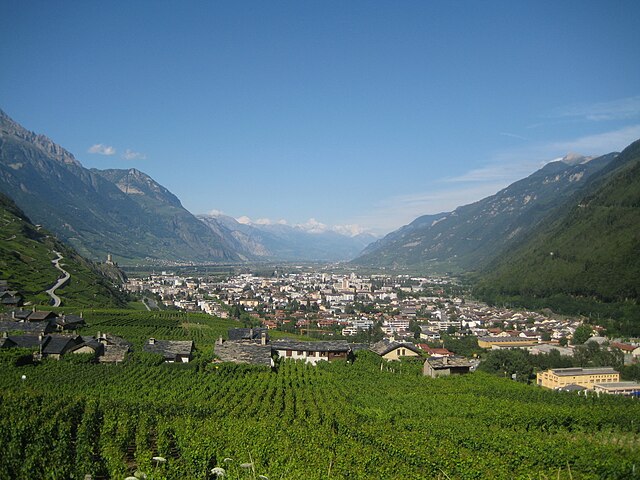

Мартиньи
Hiking in Мартиньи
Martigny is a charming town located in the Valais region of Switzerland, surrounded by stunning Alpine scenery and offering a variety of hiking opportunities. Here are some highlights of hiking in and around Martigny:...
- Страна:
- Почтовый код: 1920
- Телефонный код: 027
- Код автомобильного номера: VS
- Координаты: 46° 6' 0" N, 7° 4' 22" E
- GPS треки (wikiloc): [Ссылка]
- Высота над уровнем моря: 471 м m
- Площадь: 24.97 кв.км
- Население: 17998
- Веб сайт: [Ссылка]


Саксон
- коммуна в кантоне Валле, Швейцария
Hiking in Саксон
Hiking in Saxon, Switzerland, offers breathtaking landscapes and a variety of trails suitable for different skill levels. Here’s a guide to help you explore this beautiful region:...
- Страна:
- Почтовый код: 1907
- Телефонный код: 027
- Код автомобильного номера: VS
- Координаты: 46° 9' 0" N, 7° 10' 0" E
- GPS треки (wikiloc): [Ссылка]
- Высота над уровнем моря: 466 м m
- Площадь: 23.2 кв.км
- Население: 5774
- Веб сайт: [Ссылка]


Isérables
Hiking in Isérables
Isérables is a charming village located in the Valais region of Switzerland, known for its beautiful alpine scenery and well-maintained hiking trails. Here are some highlights and tips for hiking in Isérables:...
- Страна:
- Почтовый код: 1914
- Телефонный код: 027
- Код автомобильного номера: VS
- Координаты: 46° 9' 52" N, 7° 14' 36" E
- GPS треки (wikiloc): [Ссылка]
- Высота над уровнем моря: 1106 м m
- Площадь: 15.3 кв.км
- Население: 827
- Веб сайт: [Ссылка]


Fully
Hiking in Fully
Fully is a beautiful commune located in the Valais region of Switzerland. It offers a variety of hiking opportunities for enthusiasts of all levels. The scenic landscapes, including vineyards, mountains, and views of the Rhône Valley, make it a popular destination for both local and visiting hikers....
- Страна:
- Почтовый код: 1926
- Телефонный код: 027
- Код автомобильного номера: VS
- Координаты: 46° 8' 0" N, 7° 7' 0" E
- GPS треки (wikiloc): [Ссылка]
- Высота над уровнем моря: 471 м m
- Площадь: 37.8 кв.км
- Население: 8737
- Веб сайт: [Ссылка]


Bovernier
Hiking in Bovernier
Bovernier is a charming village located in the Valais region of Switzerland, surrounded by stunning alpine landscapes. It offers a variety of hiking opportunities that cater to different skill levels, making it an excellent destination for both novice hikers and seasoned trekkers....
- Страна:
- Телефонный код: 027
- Код автомобильного номера: VS
- Координаты: 46° 5' 0" N, 7° 5' 0" E
- GPS треки (wikiloc): [Ссылка]
- Высота над уровнем моря: 613 м m
- Площадь: 13.07 кв.км
- Население: 911
- Веб сайт: [Ссылка]


Saillon
Hiking in Saillon
Saillon, a charming village in the Valais region of Switzerland, offers a variety of hiking opportunities amidst stunning alpine scenery. Here are some highlights and details to consider when planning your hiking trip in Saillon:...
- Страна:
- Почтовый код: 1913
- Телефонный код: 027
- Код автомобильного номера: VS
- Координаты: 46° 10' 0" N, 7° 11' 0" E
- GPS треки (wikiloc): [Ссылка]
- Высота над уровнем моря: 504 м m
- Площадь: 1374 кв.км
- Население: 2574
- Веб сайт: [Ссылка]
Граничит с регионами:


Saint-Maurice District
Hiking in Saint-Maurice District
The Saint-Maurice District, located in the Valais region of Switzerland, is a stunning area known for its picturesque landscapes, towering mountains, and vibrant hiking trails. Whether you're a seasoned hiker or a beginner, there's something for everyone in this region. Here are some highlights and details to consider when hiking in the Saint-Maurice District:...
- Страна:
- Код автомобильного номера: VS
- Координаты: 46° 9' 14" N, 6° 59' 54" E
- GPS треки (wikiloc): [Ссылка]
- Высота над уровнем моря: 2099 м m
- Площадь: 185.6 кв.км


Entremont District
Hiking in Entremont District
The Entremont District, located in the French Alps, is a fantastic destination for hiking enthusiasts, offering stunning landscapes and a variety of trails for all levels of hikers. The region is characterized by its alpine scenery, including majestic mountains, lush valleys, and picturesque villages, making it a great place to explore the natural beauty of the French Alps....
- Страна:
- Столица: Sembrancher
- Код автомобильного номера: VS
- Координаты: 46° 3' 42" N, 7° 16' 23" E
- GPS треки (wikiloc): [Ссылка]
- Высота над уровнем моря: 2229 м m
- Площадь: 633.2 кв.км

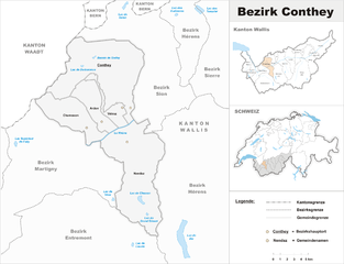
Conthey District
Hiking in Conthey District
Conthey District, located in the Canton of Valais in Switzerland, is known for its stunning landscapes, abundant natural beauty, and diverse hiking opportunities. Here are some highlights of hiking in this area:...
- Страна:
- Столица: Conthey
- Код автомобильного номера: VS
- Координаты: 46° 12' 17" N, 7° 16' 42" E
- GPS треки (wikiloc): [Ссылка]
- Высота над уровнем моря: 487 м m
- Площадь: 234.2 кв.км