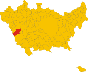
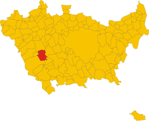
Корбетта (Corbetta, Corbetta)

.svg)
- коммуна Италии
 Hiking in Корбетта
Corbetta, located in the Lombardy region of Italy, offers a range of opportunities for outdoor enthusiasts, albeit it's not as well-known for hiking as some of the more mountainous areas in Italy. However, it is situated in the proximity of several natural parks and trails that can make for enjoyable hiking experiences.
Trails and Areas Nearby
-
Parco del Ticino: This regional park, just a short drive from Corbetta, offers a variety of trails along the Ticino River. The park features lush landscapes, diverse wildlife, and scenic views, making it ideal for hiking, biking, and birdwatching.
-
Monte Montevecchia e Della Valle del Curone Regional Park: About an hour away, this park provides more rugged terrain and a network of trails that range from easy walks to more challenging hikes. The area is known for its beautiful views and natural features.
-
The Lomellina Area: Just a few kilometers from Corbetta, the Lomellina area features gentle rolling hills and flatlands. While not mountainous, the scenery can be picturesque, especially in the countryside during spring and summer.
Hiking Recommendations
-
Difficulty Levels: If you’re new to hiking, look for easier trails in the nearby parks. More experienced hikers can seek out more challenging routes, particularly in the Montevecchia area.
-
Preparation: Always check the weather forecast before heading out, wear appropriate footwear, and carry enough water and snacks. Since some trails may not be well-marked, having a GPS or map can be beneficial.
-
Wildlife Watching: Bring binoculars if you enjoy birdwatching; the regional parks are home to a variety of bird species, especially in the wetlands.
Local Attractions
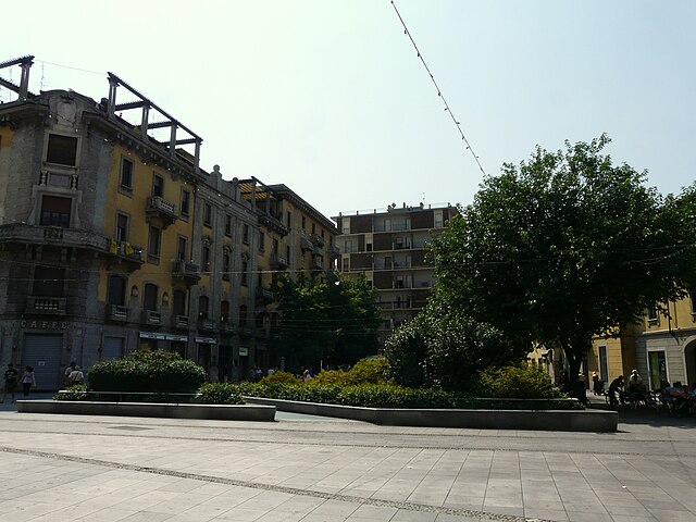
In addition to hiking, Corbetta itself offers charming Italian architecture, local eateries, and cultural sites. It’s worth taking time to explore the town and enjoy some traditional Lombard cuisine after a day on the trails.
Conclusion
While Corbetta might not be a hiking hotspot, its location allows easy access to beautiful parks and trails, making it a suitable base for outdoor activities in Lombardy. Whether you're looking for a leisurely stroll or a more strenuous hike, you can find options that suit your preferences.
- Страна:

- Почтовый код: 20011
- Телефонный код: 02
- Код автомобильного номера: MI
- Координаты: 45° 28' 0" N, 8° 55' 0" E


- GPS треки (wikiloc): [Ссылка]
- Высота над уровнем моря: 140 м m
- Площадь: 18.69 кв.км
- Население: 18366
- Веб сайт: http://www.comune.corbetta.mi.it
- Википедия русская: wiki(ru)
- Википедия английская: wiki(en)
- Википедия национальная: wiki(it)
- Хранилище Wikidata: Wikidata: Q42924
- Катеория в википедии: [Ссылка]
- код Freebase: [/m/02rhjfp]
- код GeoNames: Альт: [6539483]
- код VIAF: Альт: [136491611]
- ID отношения в OpenStreetMap: [45011]
- код темы Quora: [Corbetta]
- UN/LOCODE: [ITCBE]
- код ISTAT: 015085
- кадастровый код Италии: C986
Граничит с регионами:


Кассинетта-Луганьано
- коммуна Италии
Hiking in Кассинетта-Луганьано
Cassinetta di Lugagnano is a charming small village located in the Lombardy region of Italy, nestled near the banks of the Naviglio Grande canal. It offers a picturesque setting and a great opportunity for hiking enthusiasts to explore both the natural beauty and historical aspects of the area....
- Страна:
- Почтовый код: 20081
- Телефонный код: 02
- Код автомобильного номера: MI
- Координаты: 45° 25' 27" N, 8° 54' 31" E
- GPS треки (wikiloc): [Ссылка]
- Высота над уровнем моря: 125 м m
- Площадь: 3.32 кв.км
- Население: 1911
- Веб сайт: [Ссылка]

Робекко-суль-Навигльо
- коммуна Италии
Hiking in Робекко-суль-Навигльо
Robecco sul Naviglio is a charming town located in the Lombardy region of Italy, near the banks of the Naviglio Grande canal. While it's not a major hiking destination compared to some of the larger Italian national parks, it does offer some pleasant walking and hiking opportunities, especially along the waterways and in the surrounding rural landscapes....
- Страна:
- Почтовый код: 20087
- Телефонный код: 02
- Код автомобильного номера: MI
- Координаты: 45° 26' 0" N, 8° 53' 0" E
- GPS треки (wikiloc): [Ссылка]
- Высота над уровнем моря: 120 м m
- Площадь: 19.79 кв.км
- Население: 6766
- Веб сайт: [Ссылка]

Маджента
- коммуна Италии
Hiking in Маджента
Magenta, located in the Lombardy region of Italy, is a town rich in history and natural surroundings, though it may not be as well-known for hiking as other destinations in the region like the Alps or Lake Como. However, there are still opportunities to enjoy the outdoors and engage in hiking in and around Magenta....
- Страна:
- Почтовый код: 20013
- Телефонный код: 02
- Код автомобильного номера: MI
- Координаты: 45° 28' 0" N, 8° 53' 0" E
- GPS треки (wikiloc): [Ссылка]
- Высота над уровнем моря: 138 м m
- Площадь: 21.99 кв.км
- Население: 23845
- Веб сайт: [Ссылка]

Виттуоне
- коммуна Италии
Hiking in Виттуоне
Vittuone is a town located in the Lombardy region of Italy, not far from Milan. While it may not be as famous for hiking as some of the more mountainous areas of Italy, it still offers some pleasant walking and hiking opportunities, especially for those looking to enjoy nature close to urban settings....
- Страна:
- Почтовый код: 20010
- Телефонный код: 02
- Код автомобильного номера: MI
- Координаты: 45° 29' 0" N, 8° 57' 0" E
- GPS треки (wikiloc): [Ссылка]
- Высота над уровнем моря: 146 м m
- Площадь: 6.13 кв.км
- Население: 9063
- Веб сайт: [Ссылка]


Числьано
- коммуна Италии
Hiking in Числьано
Cisliano is a quaint municipality located in the Lombardy region of Italy, near Milan. While it may not be well-known as a major hiking destination, there are still opportunities for outdoor enthusiasts to enjoy the beautiful Italian countryside in and around the area....
- Страна:
- Почтовый код: 20080
- Телефонный код: 02
- Код автомобильного номера: MI
- Координаты: 45° 27' 0" N, 8° 59' 0" E
- GPS треки (wikiloc): [Ссылка]
- Высота над уровнем моря: 128 м m
- Площадь: 14.68 кв.км
- Население: 4867
- Веб сайт: [Ссылка]

Альбайрате
- коммуна Италии
Hiking in Альбайрате
Albaitare, a small municipality located in the Lombardy region of Italy, is known for its beautiful landscapes and proximity to nature, making it a delightful place for hiking. Here are some key points to guide you about hiking in this area:...
- Страна:
- Почтовый код: 20080
- Телефонный код: 02
- Код автомобильного номера: MI
- Координаты: 45° 25' 0" N, 8° 56' 0" E
- GPS треки (wikiloc): [Ссылка]
- Высота над уровнем моря: 124 м m
- Площадь: 14.98 кв.км
- Население: 4708
- Веб сайт: [Ссылка]


Арлуно
- коммуна Италии
Hiking in Арлуно
Arluno, situated in the Lombardy region of Italy, is not widely known as a hiking destination compared to some other areas in Italy. However, there are opportunities for nature walks and light hiking in and around the area, with the surrounding countryside offering some pleasant trails....
- Страна:
- Почтовый код: 20010
- Телефонный код: 02
- Код автомобильного номера: MI
- Координаты: 45° 30' 0" N, 8° 56' 0" E
- GPS треки (wikiloc): [Ссылка]
- Высота над уровнем моря: 156 м m
- Площадь: 12.36 кв.км
- Население: 11807
- Веб сайт: [Ссылка]


Санто-Стефано-Тичино
- коммуна Италии
Hiking in Санто-Стефано-Тичино
Santo Stefano Ticino is a charming municipality located in the metropolitan area of Milan, Italy. While it's not widely known for rugged hiking trails like some of the more mountainous regions of Italy, it offers a few opportunities for pleasant walks in a picturesque setting....
- Страна:
- Почтовый код: 20010
- Телефонный код: 02
- Код автомобильного номера: MI
- Координаты: 45° 29' 0" N, 8° 55' 0" E
- GPS треки (wikiloc): [Ссылка]
- Высота над уровнем моря: 152 м m
- Площадь: 5.01 кв.км
- Население: 4954
- Веб сайт: [Ссылка]