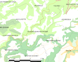
Cour-Saint-Maurice (Cour-Saint-Maurice)

- коммуна во Франции
 Hiking in Cour-Saint-Maurice
Cour-Saint-Maurice is a picturesque village in the French Alps, known for its stunning natural beauty and excellent hiking opportunities. Nestled in the Auvergne-Rhône-Alpes region, it offers a variety of trails that cater to all skill levels, from leisurely walks through charming valleys to more challenging treks that lead to breathtaking mountain vistas.
Hiking Trails
-
Le Roc des Boeufs: This trail is suitable for intermediate hikers and provides stunning views of the surrounding mountain ranges. The path winds through beautiful alpine flora, and once you reach the summit, you're rewarded with panoramic views.
-
Col de l'Auguille: This is a more challenging trek that climbs to a mountain pass. The trail features steep sections and rocky terrain, offering an adventurous experience for seasoned hikers. The vistas from the summit are truly spectacular, showcasing the majesty of the Alps.
-
Family-friendly Paths: For those hiking with children or looking for a more leisurely experience, there are several shorter, well-marked paths that take you through lush meadows and along streams, making it easy to enjoy the local wildlife and scenery.
Best Time to Hike
The best time for hiking in Cour-Saint-Maurice is typically late spring through early autumn (May to September), when the weather is generally mild, and the trails are free of snow. Late spring brings wildflowers, while autumn showcases vibrant fall foliage.
Safety Tips
- Weather Check: Always check the weather forecast before heading out, as conditions can change rapidly in the mountains.
- Gear Up: Wear proper footwear, bring sufficient water, snacks, and a first-aid kit. A map or GPS device can also be very helpful.
- Wildlife Awareness: Be mindful of local wildlife and maintain a safe distance if you encounter animals.
Additional Activities
Apart from hiking, Cour-Saint-Maurice also offers opportunities for mountain biking, rock climbing, and even winter sports like skiing and snowshoeing in the colder months.
Whether you’re looking for a peaceful nature walk or an exhilarating mountain adventure, Cour-Saint-Maurice has it all. Enjoy your hiking experience!
- Страна:

- Почтовый код: 25380
- Координаты: 47° 15' 22" N, 6° 42' 3" E


- GPS треки (wikiloc): [Ссылка]
- Площадь: 4.47 кв.км
- Население: 161
- Википедия английская: wiki(en)
- Википедия национальная: wiki(fr)
- Хранилище Wikidata: Wikidata: Q906939
- Катеория в википедии: [Ссылка]
- код Freebase: [/m/03mgsfk]
- код Freebase: [/m/03mgsfk]
- код GeoNames: Альт: [6429735]
- код GeoNames: Альт: [6429735]
- номер SIREN: [212501738]
- номер SIREN: [212501738]
- код BNF: [15252399f]
- код BNF: [15252399f]
- код муниципалитета INSEE: 25173
- код муниципалитета INSEE: 25173
Граничит с регионами:


Belleherbe
- коммуна во Франции
Hiking in Belleherbe
Belleherbe is a charming village located in the Doubs department of the Bourgogne-Franche-Comté region in eastern France. It’s surrounded by beautiful landscapes, making it a great spot for hiking enthusiasts. Here are some key details about hiking in and around Belleherbe:...
- Страна:
- Почтовый код: 25380
- Координаты: 47° 15' 43" N, 6° 39' 30" E
- GPS треки (wikiloc): [Ссылка]
- Площадь: 16.13 кв.км
- Население: 604

Orgeans-Blanchefontaine
- коммуна во Франции
Hiking in Orgeans-Blanchefontaine
Orgeans-Blanchefontaine, located in the Vosges department in northeastern France, is an excellent destination for hiking enthusiasts. The region is known for its beautiful natural landscapes, dense forests, and numerous trails that cater to various skill levels. Here’s what you should know about hiking in this picturesque area:...
- Страна:
- Почтовый код: 25120
- Координаты: 47° 15' 48" N, 6° 44' 37" E
- GPS треки (wikiloc): [Ссылка]
- Высота над уровнем моря: 450 м m
- Площадь: 4.83 кв.км
- Население: 49


Battenans-Varin
- коммуна во Франции
Hiking in Battenans-Varin
Battenans-Varin, a charming commune in the Bourgogne-Franche-Comté region of France, offers a picturesque setting for hiking enthusiasts. The area is characterized by its natural beauty, with rolling hills, lush forests, and scenic trails that vary in difficulty....
- Страна:
- Почтовый код: 25380
- Координаты: 47° 14' 56" N, 6° 42' 43" E
- GPS треки (wikiloc): [Ссылка]
- Высота над уровнем моря: 550 м m
- Площадь: 6.38 кв.км
- Население: 79


Vauclusotte
- коммуна во Франции
Hiking in Vauclusotte
Vaucluse, located in the Provence-Alpes-Côte d'Azur region of southeastern France, is renowned for its stunning landscapes, picturesque villages, and diverse hiking trails that cater to various skill levels. Here are some key highlights for hiking in the Vaucluse region:...
- Страна:
- Почтовый код: 25380
- Координаты: 47° 16' 45" N, 6° 44' 5" E
- GPS треки (wikiloc): [Ссылка]
- Площадь: 7.62 кв.км
- Население: 94


Vaucluse
- коммуна во Франции
Hiking in Vaucluse
Vaucluse, located in the Doubs department of France, is a region known for its picturesque landscapes, rolling hills, and diverse natural beauty, making it an excellent destination for hiking enthusiasts. Here are some highlights and tips for hiking in Vaucluse:...
- Страна:
- Почтовый код: 25380
- Координаты: 47° 15' 30" N, 6° 41' 14" E
- GPS треки (wikiloc): [Ссылка]
- Площадь: 5.01 кв.км
- Население: 119