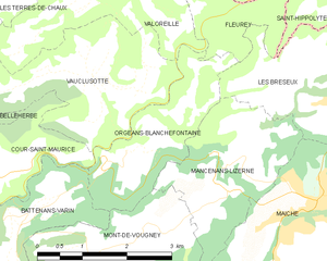
Battenans-Varin (Battenans-Varin)

- коммуна во Франции
 Hiking in Battenans-Varin
Battenans-Varin, a charming commune in the Bourgogne-Franche-Comté region of France, offers a picturesque setting for hiking enthusiasts. The area is characterized by its natural beauty, with rolling hills, lush forests, and scenic trails that vary in difficulty.
Key Highlights for Hiking in Battenans-Varin:
-
Scenic Trails: The region features several hiking trails that wind through the lush landscapes. You can explore forested areas, enjoy views of the countryside, and potentially spot local wildlife.
-
Accessibility: Many trails in and around Battenans-Varin are accessible to hikers of different skill levels. It's advisable to check local maps and signage to choose a route that suits your hiking capacity.
-
Natural Attractions: Depending on the time of year, you may encounter beautiful wildflowers in spring or vibrant autumn foliage. The limestone hills and valleys also add to the scenic charm.
-
Local Culture: Hiking can be a way to immerse yourself in the local culture, as you may pass through or near small villages, vineyards, and farms where you can learn about the area's history.
-
Nearby Attractions: Consider combining your hike with visits to nearby towns such as Montbéliard or Belfort, where you can explore historical sites, enjoy local cuisine, and experience the region's heritage.
Tips for Hiking in Battenans-Varin:
- Prepare for Weather: Weather can be variable, so dress in layers and bring appropriate gear, including waterproof clothing if rain is forecasted.
- Stay Hydrated: Be sure to carry enough water, especially on longer hikes.
- Respect Nature: Stick to marked trails, follow local guidelines, and practice Leave No Trace principles to help preserve the environment.
- Safety First: Inform someone about your hiking plans, especially if you're heading out on less-traveled paths.
With its stunning landscapes and tranquil environment, Battenans-Varin provides an excellent backdrop for both casual strolls and more challenging hikes. Enjoy exploring this beautiful part of France!
- Страна:

- Почтовый код: 25380
- Координаты: 47° 14' 56" N, 6° 42' 43" E


- GPS треки (wikiloc): [Ссылка]
- Высота над уровнем моря: 550 м m
- Площадь: 6.38 кв.км
- Население: 79
- Википедия английская: wiki(en)
- Википедия национальная: wiki(fr)
- Хранилище Wikidata: Wikidata: Q810926
- Катеория в википедии: [Ссылка]
- код Freebase: [/m/03mgc4s]
- код Freebase: [/m/03mgc4s]
- код GeoNames: Альт: [6616201]
- код GeoNames: Альт: [6616201]
- номер SIREN: [212500466]
- номер SIREN: [212500466]
- код BNF: [152522724]
- код BNF: [152522724]
- код муниципалитета INSEE: 25046
- код муниципалитета INSEE: 25046
Граничит с регионами:

Orgeans-Blanchefontaine
- коммуна во Франции
Hiking in Orgeans-Blanchefontaine
Orgeans-Blanchefontaine, located in the Vosges department in northeastern France, is an excellent destination for hiking enthusiasts. The region is known for its beautiful natural landscapes, dense forests, and numerous trails that cater to various skill levels. Here’s what you should know about hiking in this picturesque area:...
- Страна:
- Почтовый код: 25120
- Координаты: 47° 15' 48" N, 6° 44' 37" E
- GPS треки (wikiloc): [Ссылка]
- Высота над уровнем моря: 450 м m
- Площадь: 4.83 кв.км
- Население: 49
Saint-Julien-lès-Russey
- коммуна во Франции
Hiking in Saint-Julien-lès-Russey
Saint-Julien-lès-Russey is a charming commune located in the Doubs department of the Bourgogne-Franche-Comté region in eastern France. It's surrounded by beautiful natural landscapes, making it a great spot for hiking enthusiasts. Here are some highlights you might enjoy:...
- Страна:
- Почтовый код: 25210
- Координаты: 47° 13' 2" N, 6° 43' 28" E
- GPS треки (wikiloc): [Ссылка]
- Высота над уровнем моря: 550 м m
- Площадь: 10.01 кв.км
- Население: 163


Cour-Saint-Maurice
- коммуна во Франции
Hiking in Cour-Saint-Maurice
Cour-Saint-Maurice is a picturesque village in the French Alps, known for its stunning natural beauty and excellent hiking opportunities. Nestled in the Auvergne-Rhône-Alpes region, it offers a variety of trails that cater to all skill levels, from leisurely walks through charming valleys to more challenging treks that lead to breathtaking mountain vistas....
- Страна:
- Почтовый код: 25380
- Координаты: 47° 15' 22" N, 6° 42' 3" E
- GPS треки (wikiloc): [Ссылка]
- Площадь: 4.47 кв.км
- Население: 161
Mont-de-Vougney
- коммуна во Франции
Hiking in Mont-de-Vougney
Mont-de-Vougney is a lesser-known gem for hikers, located in the Vosges region of France near the border with Switzerland. This area is characterized by its rolling hills, dense forests, and beautiful landscapes, making it a great destination for outdoor enthusiasts....
- Страна:
- Почтовый код: 25120
- Координаты: 47° 14' 45" N, 6° 43' 53" E
- GPS треки (wikiloc): [Ссылка]
- Площадь: 7.03 кв.км
- Население: 176


Rosureux
- коммуна во Франции
Hiking in Rosureux
Rosureux is a beautiful destination for hiking enthusiasts, featuring a mix of scenic trails, diverse landscapes, and varying levels of difficulty. While the information may be slightly limited due to its lesser-known status, here are some general highlights you might expect when hiking in the Rosureux area:...
- Страна:
- Почтовый код: 25380
- Координаты: 47° 13' 6" N, 6° 41' 14" E
- GPS треки (wikiloc): [Ссылка]
- Площадь: 6.14 кв.км
- Население: 78


Vaucluse
- коммуна во Франции
Hiking in Vaucluse
Vaucluse, located in the Doubs department of France, is a region known for its picturesque landscapes, rolling hills, and diverse natural beauty, making it an excellent destination for hiking enthusiasts. Here are some highlights and tips for hiking in Vaucluse:...
- Страна:
- Почтовый код: 25380
- Координаты: 47° 15' 30" N, 6° 41' 14" E
- GPS треки (wikiloc): [Ссылка]
- Площадь: 5.01 кв.км
- Население: 119