
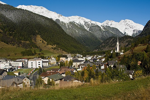
Давос (Davos, Davos)

- швейцарская коммуна
 Hiking in Давос
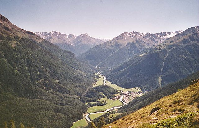
Davos, located in the Swiss Alps, is renowned for its stunning landscapes and extensive hiking trails, making it a popular destination for outdoor enthusiasts. Here are some key points to consider when hiking in Davos:
Trail Network
Davos boasts over 700 kilometers (around 435 miles) of marked hiking trails. The range of these trails accommodates all levels of experience, from easy walks to challenging mountain hikes.
Popular Hikes
-
Jakobshorn: Offers diverse trails with breathtaking panoramic views. This area is also great for those looking to combine hiking with mountain biking.
-
Rinerhorn: Features a scenic hiking route that includes alpine meadows, waterfalls, and impressive views of the surrounding mountains.
-
Sertig Valley: Ideal for a more tranquil hiking experience. The Sertig area provides picturesque landscapes and a chance to explore beautiful traditional Swiss mountain villages.
-
Dischmatal: A stunning and relatively easy hike, perfect for families, leading you through picturesque valleys and forests.
-
Crazy Klettersteig: For more adventurous hikers, this via ferrata combines climbing with hiking along a secured route in the rocky terrain.
Best Time to Hike
Hiking season in Davos typically runs from late spring to early autumn, with the peak months being June to September. The weather can be unpredictable in the mountains, so it’s important to check current conditions and be prepared for sudden changes.
Safety and Preparation
-
Gear: Proper hiking gear is crucial. Ensure you have sturdy hiking boots, weather-appropriate clothing, a map, sufficient water, and snacks.
-
Weather Awareness: Monitor the weather forecasts and understand that conditions can vary significantly at different elevations.
-
Trail Difficulty: Always choose trails that match your fitness and skill level. Detailed trail maps and information can be obtained from local tourist offices.
-
Wildlife: Respect the natural surroundings and wildlife. Stick to marked trails and be cautious, especially during wildlife sightings.
-
Group Hiking: Consider hiking in groups for safety and companionship. It’s also a good idea to inform someone about your hiking plans for safety reasons.
Additional Activities
Beyond hiking, Davos offers opportunities for mountain biking, skiing in the winter months, wellness activities, and exploring the local culture and cuisine.
Whether you’re an experienced hiker or a beginner, Davos provides an excellent backdrop for an unforgettable hiking experience in the Swiss Alps. Always remember to adhere to local regulations and practice Leave No Trace principles to help protect this beautiful environment. Enjoy your adventure!
- Страна:

- Почтовый код: 7272 Davos Clavadel; 7294 Davos Wiesen; 7278; 7277; 7276; 7270 Davos Platz; 7260 Davos Dorf; 7265 Davos Wolfgang
- Телефонный код: 081
- Код автомобильного номера: GR
- Координаты: 46° 48' 17" N, 9° 50' 14" E


- GPS треки (wikiloc): [Ссылка]
- Высота над уровнем моря: 1563 м m
- Площадь: 284 кв.км
- Население: 10937
- Веб сайт: http://www.gemeinde-davos.ch
- Википедия русская: wiki(ru)
- Википедия английская: wiki(en)
- Википедия национальная: wiki(de)
- Хранилище Wikidata: Wikidata: Q68097
- Галерея изображений в википедии: [Ссылка]
- Катеория в википедии: [Ссылка]
- код Freebase: [/m/0pbgk]
- код GeoNames: Альт: [2661041]
- код VIAF: Альт: [144322150]
- ID отношения в OpenStreetMap: [1684068]
- код GND: Альт: [4011220-2]
- идентификатор местоположения ArchINFORM: [1544]
- код LCNAF: Альт: [n80083777]
- место в MusicBrainz: [7016d578-65d4-4c86-afd7-d84515395a03]
- идентификатор HDS: [1571]
- код места в Facebook: [108456489183881]
- код в Большой российской энциклопедии онлайн: [2627025]
- код швейцарского муниципалитета: [3851]
- dmoz: Альт: [Regional/Europe/Switzerland/Cantons/Graubünden/Localities/Davos/]
Граничит с регионами:


Ароза
Hiking in Ароза
Arosa is a beautiful alpine resort located in Switzerland, renowned for its stunning landscapes, diverse trails, and welcoming atmosphere for hikers of all skill levels. Here’s an overview of hiking in Arosa:...
- Страна:
- Почтовый код: 7050
- Телефонный код: 081
- Код автомобильного номера: GR
- Координаты: 46° 46' 0" N, 9° 40' 1" E
- GPS треки (wikiloc): [Ссылка]
- Высота над уровнем моря: 2003 м m
- Площадь: 42.53 кв.км
- Население: 3185
- Веб сайт: [Ссылка]

Цернец
Hiking in Цернец
Zernez is a beautiful village located in the Swiss National Park in the Engadin Valley, known for its stunning natural landscapes, diverse ecosystems, and a variety of hiking trails that cater to different skill levels. Here are some highlights and tips for hiking in Zernez:...
- Страна:
- Почтовый код: 7530
- Телефонный код: 081
- Код автомобильного номера: GR
- Координаты: 46° 41' 59" N, 10° 5' 59" E
- GPS треки (wikiloc): [Ссылка]
- Высота над уровнем моря: 2216 м m
- Площадь: 344.04 кв.км
- Население: 1532
- Веб сайт: [Ссылка]


Шмиттен
Hiking in Шмиттен
Schmitten is a picturesque village located in the Graubünden region of Switzerland, nestled within the beauty of the Swiss Alps. Hiking in this area offers stunning landscapes, fresh mountain air, and a variety of trails suitable for different skill levels....
- Страна:
- Почтовый код: 7493
- Телефонный код: 081
- Код автомобильного номера: GR
- Координаты: 46° 41' 14" N, 9° 40' 20" E
- GPS треки (wikiloc): [Ссылка]
- Высота над уровнем моря: 1699 м m
- Площадь: 11.32 кв.км
- Население: 246
- Веб сайт: [Ссылка]


Шчанф
Hiking in Шчанф
S-chanf, a picturesque village located in the Engadin Valley of Switzerland, offers a variety of hiking opportunities for outdoor enthusiasts of all skill levels. Here are some aspects to consider when hiking in this beautiful area:...
- Страна:
- Почтовый код: 7525
- Телефонный код: 081
- Код автомобильного номера: GR
- Координаты: 46° 36' 59" N, 9° 59' 0" E
- GPS треки (wikiloc): [Ссылка]
- Высота над уровнем моря: 1878 м m
- Площадь: 138.03 кв.км
- Население: 685
- Веб сайт: [Ссылка]

Суш
Hiking in Суш
Susch, a picturesque village located in the Lower Engadine region of Switzerland, offers a range of hiking opportunities that showcase its stunning alpine scenery and cultural heritage. Here are some things to know about hiking in Susch:...
- Страна:
- Почтовый код: 7542
- Телефонный код: 081
- Код автомобильного номера: GR
- Координаты: 46° 45' 3" N, 10° 1' 20" E
- GPS треки (wikiloc): [Ссылка]
- Высота над уровнем моря: 1856 м m
- Площадь: 93.93 кв.км
- Веб сайт: [Ссылка]