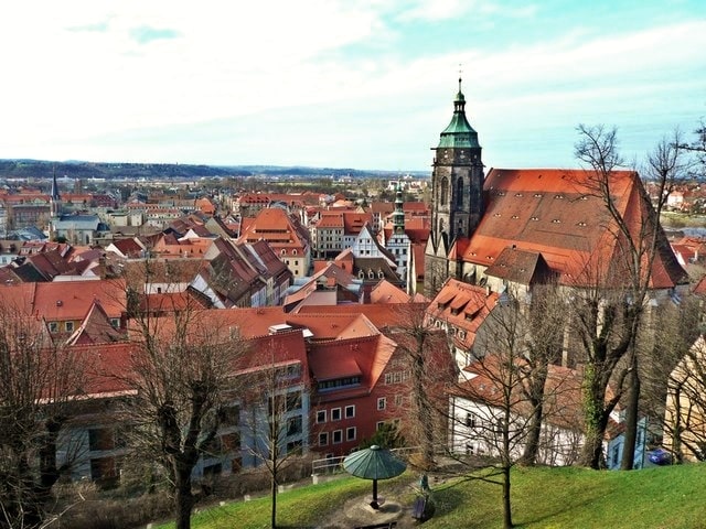
Дона (Dohna, Dohna)

- город в Саксонии, Германия
 Hiking in Дона
Hiking in Dohna, a small town in Saxony, Germany, offers a scenic experience with beautiful landscapes and trails. Here are some key points to consider when hiking in this area:
Scenic Routes
- Elbe River Trails: The nearby Elbe River provides picturesque views and opportunities to hike along its banks, where you can enjoy the serene environment and local flora and fauna.
- Saxon Switzerland National Park: Located not far from Dohna, this park features stunning sandstone formations, deep gorges, and lush forests. It’s famous for its hiking trails, including the iconic Bastei Bridge.
Difficulty Levels
- The trails vary in difficulty, ranging from easy walks suitable for families to more challenging hikes for experienced trekkers. Always check trail markers and maps for ratings.
Recommended Trails
- Dohna to the Elbe: This route takes you from the town down to the river, perfect for a leisurely hike while enjoying the scenery.
- Views over the Town: There are trails that provide elevated views of Dohna and the surrounding countryside, making for excellent photo opportunities.
Seasonal Tips
- Spring and summer are ideal for hiking in Dohna due to mild weather and blooming scenery. Fall offers stunning foliage, while winter hiking can be beautiful but may require appropriate gear for cold weather.
Safety Considerations
- Ensure you have proper footwear and clothing, carry enough water and snacks, and inform someone of your hiking plans.
- Always check the weather forecast before heading out, as conditions can change rapidly.
Local Amenities
- After a hike, you can explore the town of Dohna, which has local cafes and restaurants where you can enjoy a meal and refresh before or after your hike.
Wildlife and Nature
- Keep an eye out for local wildlife along the trails, and be respectful of nature by staying on marked paths and following any guidelines.
Whether you are looking for a peaceful day out in nature or an adventurous trek, Dohna and its surroundings have plenty to offer for hikers of all levels. Happy hiking!
- Страна:

- Почтовый код: 01809
- Телефонный код: 03529
- Код автомобильного номера: PIR
- Координаты: 50° 57' 17" N, 13° 51' 27" E


- GPS треки (wikiloc): [Ссылка]
- Высота над уровнем моря: 164 м m
- Площадь: 28.58 кв.км
- Население: 6270
- Веб сайт: https://www.stadt-dohna.de/
- Википедия русская: wiki(ru)
- Википедия английская: wiki(en)
- Википедия национальная: wiki(de)
- Хранилище Wikidata: Wikidata: Q6474
- Галерея изображений в википедии: [Ссылка]
- Катеория в википедии: [Ссылка]
- код Freebase: [/m/04h7wq]
- код Freebase: [/m/04h7wq]
- код GeoNames: Альт: [2936470]
- код GeoNames: Альт: [2936470]
- код VIAF: Альт: [233865264]
- код VIAF: Альт: [233865264]
- ID отношения в OpenStreetMap: [455485]
- ID отношения в OpenStreetMap: [455485]
- код GND: Альт: [4431519-3]
- код GND: Альт: [4431519-3]
- место в MusicBrainz: [0b4dd4a6-87b1-4e5f-a80e-c02ea4944315]
- место в MusicBrainz: [0b4dd4a6-87b1-4e5f-a80e-c02ea4944315]
- код Historical Gazetteer: [DOHHNAJO60WX]
- код Historical Gazetteer: [DOHHNAJO60WX]
- код места в Facebook: [109473479070452]
- код места в Facebook: [109473479070452]
- идентификатор муниципалитетов в Германии: 14628080
- идентификатор муниципалитетов в Германии: 14628080
Включает регионы:
Burgstädtel
Hiking in Burgstädtel
Burgstädtel is a quaint locality near Dohna, located in Saxony, Germany. The surrounding area is rich in natural beauty, making it an appealing destination for hiking enthusiasts....
- Страна:
- Почтовый код: 01809
- Телефонный код: 0351
- Координаты: 50° 58' 15" N, 13° 47' 17" E
- GPS треки (wikiloc): [Ссылка]
- Высота над уровнем моря: 250 м m
Sürßen
Hiking in Sürßen
Sürßen is a small village located in the district of Göppingen, in the state of Baden-Württemberg, Germany. While it may not be a prominent hiking destination, the surrounding region offers some lovely trails for outdoor enthusiasts. Here are a few key points regarding hiking in and around Sürßen:...
- Страна:
- Почтовый код: 01809
- Телефонный код: 03529
- Координаты: 50° 57' 0" N, 13° 50' 0" E
- GPS треки (wikiloc): [Ссылка]
- Высота над уровнем моря: 230 м m
Gamig
Hiking in Gamig
It seems there might be a slight misunderstanding or a typographical error regarding "Gamig." If you're referring to a specific location, it would help to have the correct name or more context about the area. If you meant "Gammig," "Garmisch," or any other hiking destination, please let me know!...
- Страна:
- Почтовый код: 01809
- Телефонный код: 03529
- Координаты: 50° 57' 40" N, 13° 50' 30" E
- GPS треки (wikiloc): [Ссылка]
- Высота над уровнем моря: 190 м m
Meusegast
Hiking in Meusegast
Meusegast doesn't appear to be a well-known hiking destination as of my last knowledge update in October 2023. It’s possible that you might be referring to "Meuse," which is a region in Belgium and France, famous for its beautiful landscapes and hiking trails....
- Страна:
- Почтовый код: 01809
- Телефонный код: 035027
- Координаты: 50° 55' 50" N, 13° 52' 50" E
- GPS треки (wikiloc): [Ссылка]
- Высота над уровнем моря: 244 м m
Gorknitz
Hiking in Gorknitz
Gorknitz, a small village in the Thuringia region of Germany, is surrounded by beautiful landscapes that make it an attractive destination for hiking enthusiasts. While it might not be as well-known as some larger hiking areas, Gorknitz offers a variety of trails that cater to different skill levels, along with the scenic beauty of the Thuringian Forest....
- Страна:
- Почтовый код: 01809
- Телефонный код: 03529
- Координаты: 50° 57' 25" N, 13° 49' 45" E
- GPS треки (wikiloc): [Ссылка]
- Высота над уровнем моря: 220 м m
Krebs
Hiking in Krebs
Krebs, located near Dohna in Germany, offers a beautiful setting for hiking enthusiasts. The region is characterized by lush landscapes, diverse terrain, and scenic views, making it an ideal spot for both casual walkers and more experienced hikers....
- Страна:
- Почтовый код: 01809
- Телефонный код: 03501
- Координаты: 50° 56' 15" N, 13° 53' 30" E
- GPS треки (wikiloc): [Ссылка]
- Высота над уровнем моря: 175 м m
Köttewitz
Hiking in Köttewitz
Köttewitz is a small village located in the Saxony region of Germany, which offers a serene environment and beautiful landscapes ideal for hiking enthusiasts. While it may not have the same level of recognition as bigger tourist destinations, the surrounding areas provide plenty of opportunities for outdoor activities....
- Страна:
- Почтовый код: 01809
- Телефонный код: 03529
- Координаты: 50° 56' 20" N, 13° 52' 20" E
- GPS треки (wikiloc): [Ссылка]
- Высота над уровнем моря: 205 м m
Röhrsdorf
Hiking in Röhrsdorf
Röhrsdorf, located near Dohna in Saxony, Germany, offers a picturesque setting for hiking enthusiasts. The area combines beautiful landscapes, including rolling hills, lush forests, and winding paths, making it perfect for both casual walkers and seasoned hikers....
- Страна:
- Почтовый код: 01809
- Телефонный код: 0351
- Координаты: 50° 57' 50" N, 13° 48' 30" E
- GPS треки (wikiloc): [Ссылка]
- Высота над уровнем моря: 225 м m
Tronitz
Hiking in Tronitz
Tronitz, located near Dohna in Saxony, Germany, offers a variety of hiking opportunities amidst beautiful natural landscapes. Although it may not be as widely known as some other hiking destinations, its charm lies in the tranquility and scenic views it provides....
- Страна:
- Почтовый код: 01809
- Телефонный код: 03529
- Координаты: 50° 56' 40" N, 13° 49' 10" E
- GPS треки (wikiloc): [Ссылка]
Borthen
Hiking in Borthen
Borthen is a small village in Shropshire, England, and it serves as a great base for exploring the scenic countryside and several hiking trails in the surrounding area. The landscape is characterized by lush green fields, woodlands, and rolling hills, providing diverse terrains for hikers of all skill levels....
- Страна:
- Почтовый код: 01809
- Телефонный код: 0351
- Координаты: 50° 58' 12" N, 13° 48' 0" E
- GPS треки (wikiloc): [Ссылка]
- Высота над уровнем моря: 230 м m
Bosewitz
Hiking in Bosewitz
Bosewitz is known for its picturesque landscapes and diverse hiking trails, making it a great destination for outdoor enthusiasts. Here are some key points about hiking in the area:...
- Страна:
- Почтовый код: 01809
- Телефонный код: 03529
- Координаты: 50° 57' 55" N, 13° 49' 50" E
- GPS треки (wikiloc): [Ссылка]
- Высота над уровнем моря: 190 м m
Граничит с регионами:


Дрезден
- город в Германии, административный центр Саксонии, на реке Эльбе
Hiking in Дрезден
Dresden, located in eastern Germany, is not only known for its rich history and stunning architecture but also offers wonderful hiking opportunities in its surrounding areas. Here are some highlights:...
- Страна:
- Почтовый код: 01279; 01129; 01307; 01127; 01159; 01099; 01097; 01069; 01309; 01326; 01067
- Телефонный код: 35201; 351
- Код автомобильного номера: DD
- Координаты: 51° 2' 57" N, 13° 44' 18" E
- GPS треки (wikiloc): [Ссылка]
- Высота над уровнем моря: 112 м m
- Площадь: 328.48 кв.км
- Население: 550948
- Веб сайт: [Ссылка]


Бареталь
Hiking in Бареталь
Bahretal is a picturesque municipality in Saxony, Germany, known for its charming landscapes and opportunities for hiking and outdoor activities. While it may not be as widely recognized as some major hiking destinations, it offers a variety of trails and scenic routes that cater to both casual walkers and more experienced hikers....
- Страна:
- Почтовый код: 01819
- Телефонный код: 035025; 035023
- Код автомобильного номера: PIR
- Координаты: 50° 53' 15" N, 13° 54' 0" E
- GPS треки (wikiloc): [Ссылка]
- Высота над уровнем моря: 299 м m
- Площадь: 36.47 кв.км
- Население: 2193
- Веб сайт: [Ссылка]

Пирна
- город в Германии
Hiking in Пирна
Pirna, located in Germany’s Saxon Switzerland region, is a fantastic destination for hiking enthusiasts. The area is renowned for its stunning sandstone formations, deep gorges, and lush forests, making it a picturesque and diverse hiking environment....
- Страна:
- Почтовый код: 01796; 8300
- Телефонный код: 03501
- Код автомобильного номера: PIR
- Координаты: 50° 57' 44" N, 13° 56' 25" E
- GPS треки (wikiloc): [Ссылка]
- Высота над уровнем моря: 118 м m
- Площадь: 53.06 кв.км
- Население: 38310
- Веб сайт: [Ссылка]


Хайденау
Hiking in Хайденау
Heidenau, located in Germany near the Elbe River and in close proximity to the picturesque Saxon Switzerland National Park, offers a variety of hiking opportunities for enthusiasts of all skill levels. Here are some highlights of hiking in and around Heidenau:...
- Страна:
- Почтовый код: 01801–01809
- Телефонный код: 03529
- Код автомобильного номера: PIR
- Координаты: 50° 59' 0" N, 13° 52' 0" E
- GPS треки (wikiloc): [Ссылка]
- Высота над уровнем моря: 121 м m
- Площадь: 11.07 кв.км
- Население: 16608
- Веб сайт: [Ссылка]


Крайша
Hiking in Крайша
Kreischa is a charming village located in the Saxon Switzerland region of Germany, not far from the city of Dresden. It provides access to beautiful hiking trails that cater to various skill levels. Here are some highlights and tips for hiking in and around Kreischa:...
- Страна:
- Почтовый код: 01731
- Телефонный код: 035206
- Код автомобильного номера: PIR
- Координаты: 50° 57' 0" N, 13° 46' 0" E
- GPS треки (wikiloc): [Ссылка]
- Высота над уровнем моря: 257 м m
- Площадь: 28.97 кв.км
- Население: 4517
- Веб сайт: [Ссылка]


Мюглицталь
Hiking in Мюглицталь
Müglitztal, located in the Saxon Switzerland region of Germany, is a stunning destination for hiking enthusiasts. This valley is carved out by the river Müglitz and set against a backdrop of striking sandstone formations, lush forests, and picturesque villages. Here are some key aspects to consider if you're planning a hiking trip to Müglitztal:...
- Страна:
- Почтовый код: 01809
- Телефонный код: 035206; 035027
- Код автомобильного номера: PIR
- Координаты: 50° 55' 0" N, 13° 49' 0" E
- GPS треки (wikiloc): [Ссылка]
- Высота над уровнем моря: 396 м m
- Площадь: 21.00 кв.км
- Население: 1916
- Веб сайт: [Ссылка]