
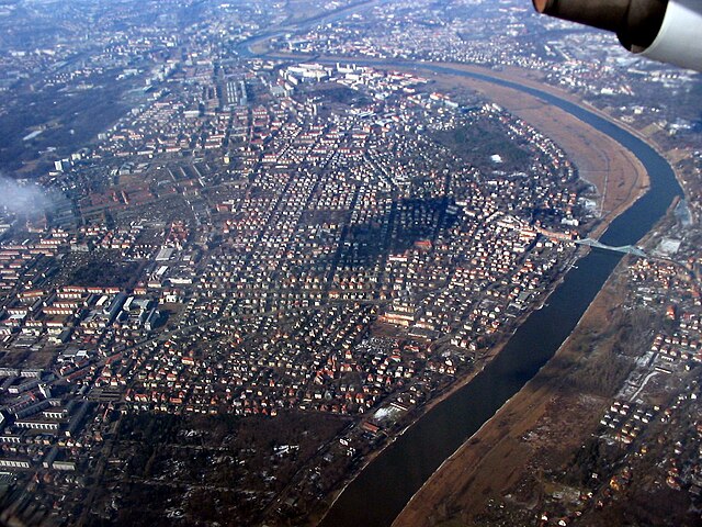
Дрезден (Dresden, Dresden)


- город в Германии, административный центр Саксонии, на реке Эльбе
 Hiking in Дрезден
Dresden, located in eastern Germany, is not only known for its rich history and stunning architecture but also offers wonderful hiking opportunities in its surrounding areas. Here are some highlights:
1.
- Location: About 30 kilometers southeast of Dresden.
- Features: Famous for its striking sandstone formations, deep valleys, and stunning vistas. The park offers a range of trails for various skill levels.
- Popular Hikes:
- Bastei Bridge: A scenic trail that leads to the iconic Bastei Bridge, with breathtaking views over the Elbe River and surrounding landscape.
- Schrammsteine: A more challenging hike that rewards with spectacular panoramas over the region's rugged terrain.
2.
- Location: Follows the Elbe River from Dresden to the Czech Republic border.
- Features: A flat, well-marked path ideal for both walking and cycling, offering beautiful views of the river, vineyards, and historical towns along the way.
- Length: The stretch from Dresden to Bad Schandau is particularly popular.
3.
- Location: This large forested area is located within the city limits of Dresden.
- Features: Offers numerous trails for hiking, running, and cycling. It's a great place for a leisurely day hike close to the city center.
- Tip: The area is also known for its rich variety of flora and fauna, making it perfect for nature lovers.
4.
- Location: About 14 kilometers northwest of Dresden.
- Features: Combine a visit to the picturesque Moritzburg Castle with a scenic hike around the surrounding forest and lakes. There are marked trails that offer both short walks and longer hikes.
5.
- Consider Joining: If you're new to hiking or want to explore more off-the-beaten-path trails, consider joining local hiking clubs or hiring a guide. They can offer valuable insights and lead you through some lesser-known areas.
- Weather: Check the weather before heading out, as conditions can change rapidly, especially in the mountains.
- Gear: Wear appropriate hiking shoes and bring enough water, snacks, and a map or GPS device.
- Safety: Stay on marked trails and be aware of your surroundings, especially in steep or rocky areas.
Whether you’re looking for a casual walk or a more challenging hike, Dresden and its surroundings offer a variety of options that allow you to immerse yourself in the natural beauty of the region. Happy hiking!
- Страна:

- Почтовый код: 01279; 01129; 01307; 01127; 01159; 01099; 01097; 01069; 01309; 01326; 01067
- Телефонный код: 35201; 351
- Код автомобильного номера: DD
- Координаты: 51° 2' 57" N, 13° 44' 18" E


- GPS треки (wikiloc): [Ссылка]
- Высота над уровнем моря: 112 м m
- Площадь: 328.48 кв.км
- Население: 550948
- Веб сайт: https://www.dresden.de/
- Википедия русская: wiki(ru)
- Википедия английская: wiki(en)
- Википедия национальная: wiki(de)
- Хранилище Wikidata: Wikidata: Q1731
- Галерея изображений в википедии: [Ссылка]
- Катеория в википедии: [Ссылка]
- Карты в википедии: [Ссылка]
- код Freebase: [/m/09b9m]
- код GeoNames: Альт: [2935022]
- код BNF: [119742433]
- код VIAF: Альт: [146756224]
- ID отношения в OpenStreetMap: [191645]
- код GND: Альт: [4012995-0]
- идентификатор местоположения ArchINFORM: [458]
- код LCNAF: Альт: [n79085026]
- место в MusicBrainz: [624f2956-bfdb-43a9-8924-9aadb812ee04]
- WOEID: [645686]
- код темы Quora: [Dresden-Germany]
- код TGN: [7004455]
- код в Encyclopædia Universalis: [dresde]
- код Historical Gazetteer: [DREDENJO61UB]
- EMLO location ID: [139dec04-c84a-403e-bf5b-57c9ab6c70e7]
- код места в Facebook: [106661926035646]
- код в Большой российской энциклопедии онлайн: [2631634]
- код NKC: [ge129086]
- dmoz: Альт: [Regional/Europe/Germany/States/Saxony/Localities/Dresden/]
- код NLI: [000187634]
- код NUTS: [DED21]
- код YSO: [166541]
- Nomisma ID: [dresden]
- код статьи Klexikon: [Dresden]
- FAST ID: [1205937]
- идентификатор NE.se: [dresden]
- код Католической энциклопедии: [05156b]
- Image Archive, Herder Institute: [Q1731]
- справка РИА Новости: [54680658]
- идентификатор муниципалитетов в Германии: 14612000
- код US National Archives: 10044802
- код района Германии: 14612
Включает регионы:


Cossebaude
Hiking in Cossebaude
Cossebaude is a district located in the city of Dresden, Germany. While it may not be known as a major hiking destination compared to some of the nearby regions like the Saxon Switzerland National Park, there are still plenty of opportunities for outdoor activities and walking in and around the area....
- Страна:
- Координаты: 51° 5' 18" N, 13° 37' 46" E
- GPS треки (wikiloc): [Ссылка]
- Площадь: 10 кв.км
Mobschatz
Hiking in Mobschatz
Mobschatz is a small locality in Germany, located south of the city of Leipzig in Saxony. While not a widely recognized hiking destination, the area surrounding Mobschatz offers a variety of scenic landscapes that can appeal to outdoor enthusiasts....
- Страна:
- Координаты: 51° 4' 39" N, 13° 38' 36" E
- GPS треки (wikiloc): [Ссылка]
- Площадь: 8.50 кв.км
Gompitz
Hiking in Gompitz
Gompitz is a small district located in the city of Dresden, Germany. While it may not be as widely known as some larger hiking destinations, it offers opportunities for outdoor enthusiasts to explore the surrounding natural beauty and enjoy a variety of hiking experiences....
- Страна:
- Координаты: 51° 2' 39" N, 13° 37' 33" E
- GPS треки (wikiloc): [Ссылка]
- Площадь: 11.72 кв.км

Oberwartha
Hiking in Oberwartha
Oberwartha, located in the eastern part of Germany in the state of Saxony, offers visitors a range of hiking opportunities that showcase the area’s natural beauty and picturesque landscapes. This village is close to the city of Dresden and is a great starting point for exploring the surrounding region....
- Страна:
- Координаты: 51° 4' 40" N, 13° 36' 10" E
- GPS треки (wikiloc): [Ссылка]
- Площадь: 2.03 кв.км

Langebrück
Hiking in Langebrück
Langebrück is a quaint district located in the city of Dresden, Germany. While it may not be as widely recognized as a premier hiking destination, there are several lovely areas nearby that can provide enjoyable walking and hiking experiences....
- Страна:
- Почтовый код: 01465
- Координаты: 51° 7' 51" N, 13° 50' 22" E
- GPS треки (wikiloc): [Ссылка]
- Площадь: 6.95 кв.км
Schönborn
Hiking in Schönborn
Schönborn, located on the outskirts of Dresden in Germany, offers some beautiful hiking opportunities, particularly for those who enjoy scenic views, nature, and a peaceful environment. Here are some key highlights regarding hiking in this area:...
- Страна:
- Координаты: 51° 8' 50" N, 13° 51' 57" E
- GPS треки (wikiloc): [Ссылка]
- Площадь: 5.20 кв.км


Weixdorf
Hiking in Weixdorf
Weixdorf is a district in the northern part of Dresden, Germany, and while it may not be as widely known for hiking as some larger natural parks, there are still opportunities for outdoor enthusiasts to explore the local landscape. Hiking in Weixdorf offers a chance to enjoy serene scenery, local vegetation, and a peaceful atmosphere....
- Страна:
- Координаты: 51° 8' 42" N, 13° 48' 0" E
- GPS треки (wikiloc): [Ссылка]
- Площадь: 15.49 кв.км
Stadtbezirk Blasewitz
Hiking in Stadtbezirk Blasewitz
Blasewitz is a district in Dresden, Germany, located on the banks of the Elbe River, and it offers a unique blend of urban exploration and natural beauty. While it may not be as famous for hiking as larger parks or nature reserves, there are still lovely trails and areas for walks, especially along the Elbe and in the nearby hills....
- Страна:
- Координаты: 51° 3' 8" N, 13° 48' 21" E
- GPS треки (wikiloc): [Ссылка]
- Площадь: 14.49 кв.км
Cotta
Hiking in Cotta
Cotta, located in Dresden, Germany, is an area that offers a variety of urban and natural experiences for hiking enthusiasts. The region is known for its green spaces, parks, and its proximity to the scenic landscapes of Saxon Switzerland National Park, which is a short drive away....
- Страна:
- Координаты: 51° 3' 23" N, 13° 41' 16" E
- GPS треки (wikiloc): [Ссылка]
- Площадь: 19.38 кв.км
Stadtbezirk Klotzsche
Hiking in Stadtbezirk Klotzsche
Klotzsche, a district in the northern part of Dresden, Germany, offers a variety of outdoor activities and scenic hiking opportunities. Its proximity to the beautiful landscapes of the Saxon Switzerland National Park and the Elbe River makes it an attractive destination for hikers....
- Страна:
- Координаты: 51° 7' 40" N, 13° 45' 0" E
- GPS треки (wikiloc): [Ссылка]
- Площадь: 27.07 кв.км
Stadtbezirk Leuben
Hiking in Stadtbezirk Leuben
Leuben is a district located in the city of Dresden, Germany. It's known for its scenic landscapes and proximity to nature, making it a great spot for hiking enthusiasts. Here are some insights about hiking in the Leuben area:...
- Страна:
- Координаты: 51° 0' 37" N, 13° 49' 31" E
- GPS треки (wikiloc): [Ссылка]
- Площадь: 13.05 кв.км
Лошвиц
- микрорайон Дрездена
Hiking in Лошвиц
Loschwitz, located in the eastern part of Dresden, Germany, is a charming area known for its picturesque landscapes and stunning views over the Elbe River. Hiking in Loschwitz offers a great combination of beautiful natural scenery and cultural landmarks....
- Страна:
- Координаты: 51° 3' 15" N, 13° 48' 57" E
- GPS треки (wikiloc): [Ссылка]
- Площадь: 68.80 кв.км

Dresden-Neustadt
Hiking in Dresden-Neustadt
Neustadt (Stadtbezirk) is a district in the city of Dresden, Germany, and it offers several opportunities for hiking and outdoor exploration. While the district itself is urban, it’s close to various natural areas that provide excellent hiking options. Here are some highlights:...
- Страна:
- Координаты: 51° 3' 34" N, 13° 45' 10" E
- GPS треки (wikiloc): [Ссылка]
- Площадь: 14.79 кв.км
Stadtbezirk Pieschen
Hiking in Stadtbezirk Pieschen
Pieschen is a district located in Dresden, Germany, known for its blend of urban environments and nearby natural landscapes. While it may not be a traditional hiking destination, there are several opportunities for walking and exploring around Pieschen....
- Страна:
- Координаты: 51° 4' 40" N, 13° 43' 0" E
- GPS треки (wikiloc): [Ссылка]
- Площадь: 16.21 кв.км
Stadtbezirk Plauen
Hiking in Stadtbezirk Plauen
Plauen, located in the state of Saxony in Germany, is surrounded by beautiful landscapes that provide excellent opportunities for hiking enthusiasts. The Stadtbezirk, or urban district, of Plauen has access to several parks and nature areas that offer various hiking experiences....
- Страна:
- Координаты: 51° 1' 45" N, 13° 42' 26" E
- GPS треки (wikiloc): [Ссылка]
- Площадь: 15.79 кв.км

Stadtbezirk Prohlis
Hiking in Stadtbezirk Prohlis
Prohlis is a district located in the city of Dresden, Germany. While it's primarily an urban area, there are some opportunities for hiking and outdoor activities in and around the region....
- Страна:
- Координаты: 51° 0' 18" N, 13° 47' 56" E
- GPS треки (wikiloc): [Ссылка]
- Площадь: 21.15 кв.км
Альтштадт
- район в Дрездене
Hiking in Альтштадт
Altstadt, being a historic district in many cities, often features a charming combination of urban landscape and surrounding natural areas. While the term “Altstadt” generally refers to the old town of a city in German-speaking countries, hiking specifically within a city’s old district may be limited to urban walking rather than traditional hiking through nature....
- Страна:
- Координаты: 51° 3' 9" N, 13° 43' 50" E
- GPS треки (wikiloc): [Ссылка]
- Площадь: 16.97 кв.км

Altfranken
Hiking in Altfranken
Altfranken, located in Germany, is known for its picturesque landscapes, charming villages, and rich cultural history. There are various hiking opportunities in this region, allowing hikers to explore its natural beauty and historical landmarks. Here are some highlights and tips for hiking in Altfranken:...
- Страна:
- Координаты: 51° 2' 0" N, 13° 38' 45" E
- GPS треки (wikiloc): [Ссылка]
- Площадь: 1.28 кв.км
Schönfeld-Weißig
Hiking in Schönfeld-Weißig
Schönfeld-Weißig, located in the beautiful region of Saxony, Germany, is a fantastic destination for hiking enthusiasts. The area offers a picturesque landscape characterized by rolling hills, lush forests, and charming villages. Here are some highlights for hiking in Schönfeld-Weißig:...
- Страна:
- Координаты: 51° 2' 39" N, 13° 53' 41" E
- GPS треки (wikiloc): [Ссылка]
- Площадь: 41.20 кв.км
Граничит с регионами:


Баутцен
Hiking in Баутцен
Bautzen, located in the eastern part of Germany, specifically in Saxony, offers a rich landscape for hiking enthusiasts. The district is characterized by its picturesque scenery, which includes rolling hills, dense forests, and winding rivers, particularly the Spree River. Here are some key highlights about hiking in Bautzen and its surroundings:...
- Страна:
- Код автомобильного номера: KM; HY; BZ; BIW
- Координаты: 51° 17' 0" N, 14° 16' 0" E
- GPS треки (wikiloc): [Ссылка]
- Высота над уровнем моря: 178 м m
- Площадь: 2390.70 кв.км
- Население: 304691
- Веб сайт: [Ссылка]
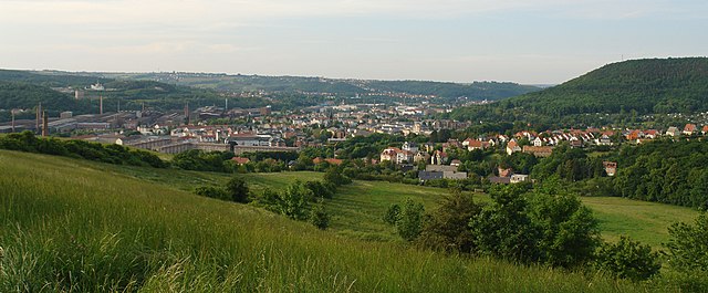
Фрайталь
- город в Саксонии
Hiking in Фрайталь
Freital, located in Saxony, Germany, is surrounded by beautiful landscapes and offers various hiking opportunities for both novice and experienced hikers. Here are some highlights about hiking in the Freital area:...
- Страна:
- Почтовый код: 01705; 8225; 8212; 8211; 8210
- Телефонный код: 0351
- Координаты: 51° 1' 0" N, 13° 39' 0" E
- GPS треки (wikiloc): [Ссылка]
- Высота над уровнем моря: 171 м m
- Площадь: 40.45 кв.км
- Население: 39300
- Веб сайт: [Ссылка]

Мейсен
- район германии в Германии, Саксония
Hiking in Мейсен
Meissen, located in the state of Saxony in Germany, is known for its picturesque landscapes, historic towns, and charming vineyards. Hiking in the Meissen district offers a variety of trails that cater to different experience levels and interests, with beautiful scenery ranging from rolling hills to the banks of the Elbe River....
- Страна:
- Код автомобильного номера: RIE; RG; MEI; GRH
- Координаты: 51° 13' 0" N, 13° 31' 0" E
- GPS треки (wikiloc): [Ссылка]
- Высота над уровнем моря: 177 м m
- Площадь: 1454.59 кв.км
- Население: 244717
- Веб сайт: [Ссылка]
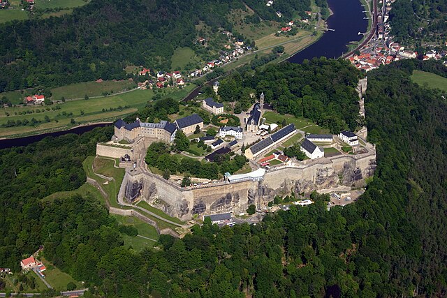
Саксонская Швейцария — Восточные Рудные Горы
- район в Саксонии (Германия)
Hiking in Саксонская Швейцария — Восточные Рудные Горы
Sächsische Schweiz-Osterzgebirge, or Saxon Switzerland and the Eastern Ore Mountains, is a stunning region in Germany, renowned for its breathtaking landscapes, unique rock formations, and extensive hiking opportunities. Here are some key features and tips for hiking in this beautiful area:...
- Страна:
- Столица: Пирна
- Код автомобильного номера: SEB; PIR; FTL; DW
- Координаты: 50° 54' 0" N, 13° 50' 0" E
- GPS треки (wikiloc): [Ссылка]
- Площадь: 1653.64 кв.км
- Население: 246066
- Веб сайт: [Ссылка]

Банневиц
- объединение общин в Саксонии
Hiking in Банневиц
Bannewitz is a charming municipality located in Saxony, Germany, not far from the city of Dresden. It offers a variety of hiking opportunities that showcase the beautiful landscapes of the region, including rolling hills, forests, and scenic views. Here are some highlights for hiking in Bannewitz:...
- Страна:
- Почтовый код: 01728
- Телефонный код: 035206; 0351
- Код автомобильного номера: PIR
- Координаты: 50° 59' 35" N, 13° 43' 0" E
- GPS треки (wikiloc): [Ссылка]
- Высота над уровнем моря: 280 м m
- Площадь: 25.81 кв.км
- Население: 10803
- Веб сайт: [Ссылка]


Дона
- город в Саксонии, Германия
Hiking in Дона
Hiking in Dohna, a small town in Saxony, Germany, offers a scenic experience with beautiful landscapes and trails. Here are some key points to consider when hiking in this area:...
- Страна:
- Почтовый код: 01809
- Телефонный код: 03529
- Код автомобильного номера: PIR
- Координаты: 50° 57' 17" N, 13° 51' 27" E
- GPS треки (wikiloc): [Ссылка]
- Высота над уровнем моря: 164 м m
- Площадь: 28.58 кв.км
- Население: 6270
- Веб сайт: [Ссылка]


Дюррёрсдорф-Диттерсбах
Hiking in Дюррёрсдорф-Диттерсбах
Dürrröhrsdorf-Dittersbach is a beautiful area located in the Saxony region of Germany, known for its picturesque landscapes, charming villages, and numerous opportunities for outdoor activities, including hiking. Here are some highlights for hiking in this region:...
- Страна:
- Почтовый код: 01833
- Телефонный код: 035026
- Код автомобильного номера: PIR
- Координаты: 51° 2' 0" N, 14° 0' 0" E
- GPS треки (wikiloc): [Ссылка]
- Высота над уровнем моря: 240 м m
- Площадь: 43.5 кв.км
- Население: 4200
- Веб сайт: [Ссылка]


Хайденау
Hiking in Хайденау
Heidenau, located in Germany near the Elbe River and in close proximity to the picturesque Saxon Switzerland National Park, offers a variety of hiking opportunities for enthusiasts of all skill levels. Here are some highlights of hiking in and around Heidenau:...
- Страна:
- Почтовый код: 01801–01809
- Телефонный код: 03529
- Код автомобильного номера: PIR
- Координаты: 50° 59' 0" N, 13° 52' 0" E
- GPS треки (wikiloc): [Ссылка]
- Высота над уровнем моря: 121 м m
- Площадь: 11.07 кв.км
- Население: 16608
- Веб сайт: [Ссылка]