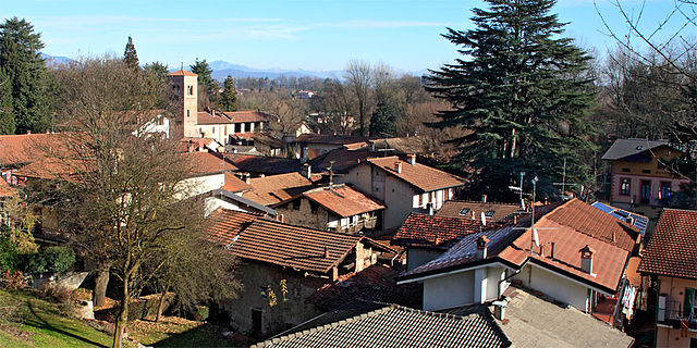
Дормеллетто (Dormelletto, Dormelletto)
- Коммуна в Италии, располагается в регионе Пьемонт, подчиняется административному центру Новара.
 Hiking in Дормеллетто
Dormelletto is a charming town located near Lake Maggiore in the Piedmont region of northern Italy. While it may not be as well-known as some other hiking destinations, it offers beautiful landscapes and access to several trails that can be enjoyed by hikers of various skill levels.
Hiking Opportunities in and around Dormelletto
-
Lake Maggiore Trails: The area surrounding Lake Maggiore features numerous trails with stunning views of the lake and surrounding mountains. You can explore coastal paths that provide scenic walks along the water’s edge, or venture into the nearby hills for a more challenging hike.
-
Nature Reserves and Parks: The nearby Parco Nazionale della Val Grande and Parco della Rocca di Angera offer a variety of hiking trails. Val Grande, in particular, is known for its rugged wilderness and is one of the largest wilderness areas in Italy, featuring numerous hiking routes that take you through pristine nature.
-
The Sacro Monte di Orta: Slightly further afield, this UNESCO World Heritage Site is characterized by a series of chapels and offers stunning views of Lake Orta. The hiking trails here are well-marked and suitable for a half-day excursion.
-
Mount Mottarone: If you’re up for a longer hike, consider heading to Mount Mottarone. It’s accessible via a drive from Dormelletto, and it offers various trails with breathtaking views of the surrounding lakes and mountain ranges.
Preparing for Your Hike
-
Map and Guide: Always have a detailed map or a local guidebook. While many trails are well-marked, having additional resources can help with navigation.
-
Gear: Wear sturdy hiking boots, carry plenty of water, and dress in layers to accommodate changes in weather.
-
Check Trail Conditions: Before you head out, check the local conditions and trail closures, especially if you’re hiking in the off-season.
-
Local Regulations: Be aware of any specific regulations or guidelines, especially in protected areas.
Conclusion
Hiking in and around Dormelletto can be a wonderful experience, combining natural beauty with the charm of the Piedmont region. Whether you’re looking for a serene lakeside stroll or a more challenging mountain hike, you’ll find plenty of opportunities to explore and enjoy the great outdoors in this enchanting part of Italy.
- Страна:

- Почтовый код: 28040
- Телефонный код: 0322
- Код автомобильного номера: NO
- Координаты: 45° 44' 0" N, 8° 34' 0" E


- GPS треки (wikiloc): [Ссылка]
- Высота над уровнем моря: 236 м m
- Площадь: 7.25 кв.км
- Население: 2600
- Веб сайт: http://www.comune.dormelletto.no.it
- Википедия русская: wiki(ru)
- Википедия английская: wiki(en)
- Википедия национальная: wiki(it)
- Хранилище Wikidata: Wikidata: Q22216
- Катеория в википедии: [Ссылка]
- код Freebase: [/m/0g8szl]
- код GeoNames: Альт: [6543424]
- код VIAF: Альт: [156175739]
- ID отношения в OpenStreetMap: [45907]
- UN/LOCODE: [ITZAI]
- код ISTAT: 003062
- кадастровый код Италии: D347
Граничит с регионами:

Арона
- коммуна Италии
Hiking in Арона
Arona, located on the western shore of Lake Maggiore in the Piedmont region of Italy, offers a variety of hiking opportunities that showcase the stunning natural beauty and diverse landscapes of the area. Here are some highlights and tips for hiking around Arona:...
- Страна:
- Почтовый код: 28041
- Телефонный код: 0322
- Код автомобильного номера: NO
- Координаты: 45° 45' 25" N, 8° 33' 36" E
- GPS треки (wikiloc): [Ссылка]
- Высота над уровнем моря: 212 м m
- Площадь: 15.17 кв.км
- Население: 13966
- Веб сайт: [Ссылка]

Кастеллетто-сопра-Тичино
- Коммуна в Италии, располагается в регионе Пьемонт, подчиняется административному центру Новара.
Hiking in Кастеллетто-сопра-Тичино
Castelletto sopra Ticino is a picturesque village located in the Piedmont region of northern Italy, nestled near the shores of Lake Maggiore and close to the Ticino River. It offers a variety of hiking opportunities that feature stunning natural landscapes, charming rural views, and fascinating cultural landmarks....
- Страна:
- Почтовый код: 28053
- Телефонный код: 0331
- Код автомобильного номера: NO
- Координаты: 45° 43' 0" N, 8° 38' 0" E
- GPS треки (wikiloc): [Ссылка]
- Высота над уровнем моря: 226 м m
- Площадь: 14.64 кв.км
- Население: 9969
- Веб сайт: [Ссылка]
Коминьяго
- Коммуна в Италии, располагается в регионе Пьемонт, подчиняется административному центру Новара.
Hiking in Коминьяго
Comignago is a charming small town located in the Piedmont region of Italy, not far from Lake Maggiore. While it may not be as widely known for hiking as more prominent locations, it offers some lovely trails and natural beauty in the surrounding area. Here are some aspects to consider if you're looking to hike in and around Comignago:...
- Страна:
- Почтовый код: 28060
- Телефонный код: 0322
- Код автомобильного номера: NO
- Координаты: 45° 43' 0" N, 8° 34' 0" E
- GPS треки (wikiloc): [Ссылка]
- Высота над уровнем моря: 268 м m
- Площадь: 4.45 кв.км
- Население: 1261
- Веб сайт: [Ссылка]


Сесто-Календе
- коммуна Италии
Hiking in Сесто-Календе
Sesto Calende is a charming town located in the province of Varese, in the Lombardy region of Italy. It's situated near the shores of Lake Maggiore and along the Ticino River, making it a beautiful destination for outdoor enthusiasts, particularly hikers. Here are some highlights about hiking in and around Sesto Calende:...
- Страна:
- Почтовый код: 21018
- Телефонный код: 0331
- Код автомобильного номера: VA
- Координаты: 45° 44' 0" N, 8° 38' 0" E
- GPS треки (wikiloc): [Ссылка]
- Высота над уровнем моря: 198 м m
- Площадь: 25.04 кв.км
- Население: 11141
- Веб сайт: [Ссылка]
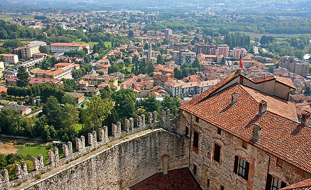

Анджера
- коммуна Италии
Hiking in Анджера
Angera, located on the shores of Lake Maggiore in Northern Italy, offers a range of hiking options that cater to different levels of experience. The area is known for its beautiful landscapes, scenic views of the lake and surrounding mountains, and charming historical features. Here are some highlights of hiking in Angera:...
- Страна:
- Почтовый код: 21021
- Телефонный код: 0331
- Код автомобильного номера: VA
- Координаты: 45° 46' 0" N, 8° 35' 0" E
- GPS треки (wikiloc): [Ссылка]
- Высота над уровнем моря: 193 м m
- Площадь: 17.72 кв.км
- Население: 5583
- Веб сайт: [Ссылка]