Сесто-Календе (Sesto Calende, Sesto Calende)

.svg)
- коммуна Италии
 Hiking in Сесто-Календе
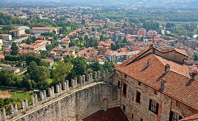
Sesto Calende is a charming town located in the province of Varese, in the Lombardy region of Italy. It's situated near the shores of Lake Maggiore and along the Ticino River, making it a beautiful destination for outdoor enthusiasts, particularly hikers. Here are some highlights about hiking in and around Sesto Calende:
Natural Attractions
-
Lake Maggiore: The area around Lake Maggiore offers various trails that provide stunning views of the lake, surrounding mountains, and nearby islands. The shoreline trails are generally well-marked and suitable for different skill levels.
-
Parco del Ticino: This park stretches along the Ticino River and is known for its rich biodiversity. Hiking here can offer you opportunities to see various birds and wildlife, along with picturesque landscapes. There are numerous trails that vary in difficulty, making it a versatile hiking area.
-
Monte Cereghino: For those looking for a bit of a challenge, trails leading up to Monte Cereghino offer rewarding views from the summit. The ascent can be steep in parts, but it often rewards hikers with panoramic views of Lake Maggiore and the surrounding landscapes.
Hiking Routes
-
Easy Trails: There are flat, lakeside paths ideal for families or beginner hikers, offering scenic vistas and a leisurely experience.
-
Moderate Trails: Trails that lead through the hills and forests surrounding Sesto Calende often have some elevation gain and provide a good workout while immersing you in nature.
-
Challenging Trails: If you’re an experienced hiker, look for routes toward the mountains or more remote areas, where you’ll encounter less traffic and have a chance to explore more rugged terrain.
Tips for Hiking in Sesto Calende
-
Equipment: Make sure to wear appropriate footwear and carry enough water and snacks, especially if you're venturing on longer hikes.
-
Weather Conditions: The weather can change rapidly in this region, so check forecasts before you head out and dress in layers.
-
Local Guidance: Consider reaching out to local hiking groups or guides who can offer insights into the best trails and hidden gems in the area.
-
Respect Nature: Follow the principles of Leave No Trace to keep the trails and natural environment pristine for future hikers.
Conclusion
Sesto Calende's natural beauty and diverse hiking options make it a great destination for anyone who enjoys outdoor activities. Whether you are looking for an easy stroll along the lakeshore or a challenging hike in the hills, there are ample opportunities to explore the stunning landscapes this region offers.
- Страна:

- Почтовый код: 21018
- Телефонный код: 0331
- Код автомобильного номера: VA
- Координаты: 45° 44' 0" N, 8° 38' 0" E


- GPS треки (wikiloc): [Ссылка]
- Высота над уровнем моря: 198 м m
- Площадь: 25.04 кв.км
- Население: 11141
- Веб сайт: http://www.comune.sesto-calende.va.it/
- Википедия русская: wiki(ru)
- Википедия английская: wiki(en)
- Википедия национальная: wiki(it)
- Хранилище Wikidata: Wikidata: Q40699
- Галерея изображений в википедии: [Ссылка]
- Катеория в википедии: [Ссылка]
- код Freebase: [/m/0fsqv0]
- код GeoNames: Альт: [6540573]
- код VIAF: Альт: [158260001]
- ID отношения в OpenStreetMap: [45846]
- идентификатор местоположения ArchINFORM: [9494]
- место в MusicBrainz: [c45e1aec-3d7e-4aef-a19d-87c54e4588de]
- код темы Quora: [Sesto-Calende]
- код TGN: [7006046]
- UN/LOCODE: [ITSEE]
- код Цифрового атласа Римской империи: [37615]
- код ISTAT: 012120
- кадастровый код Италии: I688
Граничит с регионами:

Кастеллетто-сопра-Тичино
- Коммуна в Италии, располагается в регионе Пьемонт, подчиняется административному центру Новара.
Hiking in Кастеллетто-сопра-Тичино
Castelletto sopra Ticino is a picturesque village located in the Piedmont region of northern Italy, nestled near the shores of Lake Maggiore and close to the Ticino River. It offers a variety of hiking opportunities that feature stunning natural landscapes, charming rural views, and fascinating cultural landmarks....
- Страна:
- Почтовый код: 28053
- Телефонный код: 0331
- Код автомобильного номера: NO
- Координаты: 45° 43' 0" N, 8° 38' 0" E
- GPS треки (wikiloc): [Ссылка]
- Высота над уровнем моря: 226 м m
- Площадь: 14.64 кв.км
- Население: 9969
- Веб сайт: [Ссылка]

Дормеллетто
- Коммуна в Италии, располагается в регионе Пьемонт, подчиняется административному центру Новара.
Hiking in Дормеллетто
Dormelletto is a charming town located near Lake Maggiore in the Piedmont region of northern Italy. While it may not be as well-known as some other hiking destinations, it offers beautiful landscapes and access to several trails that can be enjoyed by hikers of various skill levels....
- Страна:
- Почтовый код: 28040
- Телефонный код: 0322
- Код автомобильного номера: NO
- Координаты: 45° 44' 0" N, 8° 34' 0" E
- GPS треки (wikiloc): [Ссылка]
- Высота над уровнем моря: 236 м m
- Площадь: 7.25 кв.км
- Население: 2600
- Веб сайт: [Ссылка]
Озмате
- коммуна Италии
Hiking in Озмате
Osmate is a small municipality in the Lombardy region of Italy, nestled in the hills near Lake Maggiore. While it may not be a widely known hiking destination compared to larger parks or reserves, the surrounding area offers beautiful nature, scenic views, and a chance to explore charming Italian countryside....
- Страна:
- Почтовый код: 21018
- Телефонный код: 0331
- Код автомобильного номера: VA
- Координаты: 45° 47' 0" N, 8° 40' 0" E
- GPS треки (wikiloc): [Ссылка]
- Высота над уровнем моря: 334 м m
- Площадь: 3.52 кв.км
- Население: 817
- Веб сайт: [Ссылка]
Меркалло
- коммуна Италии
Hiking in Меркалло
Mercallo is a charming municipality located in the Lombardy region of Italy, surrounded by the picturesque landscapes of the Varese province. While Mercallo itself may not be widely known for extensive hiking trails, it serves as a wonderful base for accessing nearby natural attractions and hiking routes....
- Страна:
- Почтовый код: 21020
- Телефонный код: 0331
- Код автомобильного номера: VA
- Координаты: 45° 45' 0" N, 8° 40' 0" E
- GPS треки (wikiloc): [Ссылка]
- Высота над уровнем моря: 277 м m
- Площадь: 5.48 кв.км
- Население: 1795
- Веб сайт: [Ссылка]


Тайно
- коммуна в провинции Варезе, регион Ломбардия, Италия
Hiking in Тайно
Taino, located in the Lombardy region of Italy, is a charming village nestled near Lake Maggiore. The area is surrounded by beautiful natural landscapes, making it a great destination for hiking enthusiasts. Here are some highlights and tips for hiking in and around Taino:...
- Страна:
- Почтовый код: 21020
- Телефонный код: 0331
- Код автомобильного номера: VA
- Координаты: 45° 46' 0" N, 8° 37' 0" E
- GPS треки (wikiloc): [Ссылка]
- Высота над уровнем моря: 262 м m
- Площадь: 7 кв.км
- Население: 3697
- Веб сайт: [Ссылка]


Кадреццате
- коммуна Италии
Hiking in Кадреццате
Cadrezzate, located in the province of Varese in Italy, offers a charming environment for hiking enthusiasts. It's close to the beautiful natural landscapes of the Cuvio Valley and the nearby lakes. Here are some highlights and considerations for hiking in this area:...
- Страна:
- Почтовый код: 21020
- Телефонный код: 0331
- Код автомобильного номера: VA
- Координаты: 45° 47' 52" N, 8° 38' 37" E
- GPS треки (wikiloc): [Ссылка]
- Высота над уровнем моря: 281 м m
- Площадь: 4.73 кв.км
- Население: 1842
- Веб сайт: [Ссылка]


Верджате
- коммуна Италии
Hiking in Верджате
Vergiate, located in the Province of Varese in Northern Italy, offers several attractive hiking options for outdoor enthusiasts. The area is characterized by a mix of beautiful natural landscapes, including hills, forests, and nearby lakes, making it a great destination for hiking....
- Страна:
- Почтовый код: 21029
- Телефонный код: 0331
- Код автомобильного номера: VA
- Координаты: 45° 43' 0" N, 8° 42' 0" E
- GPS треки (wikiloc): [Ссылка]
- Высота над уровнем моря: 270 м m
- Площадь: 21.78 кв.км
- Население: 8711
- Веб сайт: [Ссылка]

Анджера
- коммуна Италии
Hiking in Анджера
Angera, located on the shores of Lake Maggiore in Northern Italy, offers a range of hiking options that cater to different levels of experience. The area is known for its beautiful landscapes, scenic views of the lake and surrounding mountains, and charming historical features. Here are some highlights of hiking in Angera:...
- Страна:
- Почтовый код: 21021
- Телефонный код: 0331
- Код автомобильного номера: VA
- Координаты: 45° 46' 0" N, 8° 35' 0" E
- GPS треки (wikiloc): [Ссылка]
- Высота над уровнем моря: 193 м m
- Площадь: 17.72 кв.км
- Население: 5583
- Веб сайт: [Ссылка]
Комаббио
- коммуна Италии
Hiking in Комаббио
Comabbio is a picturesque village located in the Lombardy region of Italy, situated near Lake Comabbio. While it's not as widely recognized as some of the larger Italian hiking destinations, it offers tranquil trails and beautiful natural landscapes, making it an ideal spot for hikers looking for a more serene experience....
- Страна:
- Почтовый код: 21020
- Телефонный код: 0331
- Код автомобильного номера: VA
- Координаты: 45° 46' 0" N, 8° 41' 0" E
- GPS треки (wikiloc): [Ссылка]
- Высота над уровнем моря: 307 м m
- Площадь: 4.69 кв.км
- Население: 1170
- Веб сайт: [Ссылка]
Голазекка
- коммуна Италии
Hiking in Голазекка
Golasecca, located in the province of Varese in Lombardy, Italy, offers a variety of hiking opportunities that showcase the beautiful natural landscapes and cultural heritage of the region. Here are some key points about hiking in Golasecca:...
- Страна:
- Почтовый код: 21010
- Телефонный код: 0331
- Код автомобильного номера: VA
- Координаты: 45° 42' 0" N, 8° 39' 0" E
- GPS треки (wikiloc): [Ссылка]
- Высота над уровнем моря: 280 м m
- Площадь: 7.44 кв.км
- Население: 2729
- Веб сайт: [Ссылка]