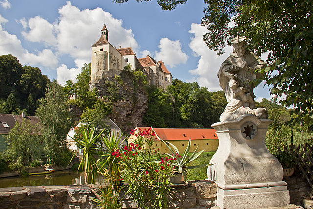
Дрозендорф-Циссерсдорф (Drosendorf-Zissersdorf, Drosendorf-Zissersdorf)
 Hiking in Дрозендорф-Циссерсдорф
Drosendorf-Zissersdorf, located in the Waldviertel region of Austria, offers picturesque landscapes and a range of hiking opportunities that showcase the natural beauty and historical significance of the area. Here are some key points to consider if you’re planning to hike in this region:
Scenic Trails
-
Diverse Terrain: The area features a mix of forested paths, open fields, and scenic views of the surrounding hills and valleys. You can expect varying degrees of difficulty depending on the trail.
-
Historical Sites: The region is rich in history, with trails that may lead you past ancient ruins, churches, and local architecture, providing a cultural backdrop to your hike.
-
Flora and Fauna: The Waldviertel region is known for its unique biodiversity. Keep an eye out for local wildlife, including various bird species, and enjoy the sight of seasonal flowers along the trails.
Popular Routes
-
Local Trails: There are several marked local hiking trails that cater to different skill levels. Some may be loop trails that allow for easier navigation and shorter hikes, while others may be more challenging and require proper preparation.
-
Themed Paths: Certain trails might focus on specific themes, such as nature education, local history, or panoramic viewpoints, enhancing the hiking experience.
Tips for Hikers
-
Prepare for Weather: The weather in the Waldviertel can change quickly, so dress in layers and be prepared for rain or sudden temperature shifts.
-
Stay Hydrated: Always carry enough water, especially if you’re hiking longer trails.
-
Navigation: Use a reliable map or GPS app to navigate the trails, as signage may vary.
-
Respect Nature: Always follow the principles of Leave No Trace by sticking to trails, disposing of waste properly, and respecting wildlife.
-
Local Guidance: Consider checking in with local tourism offices for maps, recommended routes, and the latest information on trail conditions.
Accessibility
Drosendorf-Zissersdorf is generally accessible via local transport, but if you’re traveling from larger cities in Austria, renting a car may offer more flexibility to explore various hiking spots in the region.
By taking the time to explore the hiking trails in Drosendorf-Zissersdorf, you'll not only enjoy beautiful landscapes but also immerse yourself in the rich cultural heritage of Austria's Waldviertel. Happy hiking!
- Страна:

- Почтовый код: 2095
- Телефонный код: 02915
- Код автомобильного номера: HO
- Координаты: 48° 52' 5" N, 15° 37' 1" E


- GPS треки (wikiloc): [Ссылка]
- Высота над уровнем моря: 423 м m
- Площадь: 53.45 кв.км
- Население: 1213
- Веб сайт: http://www.drosendorf.at
- Википедия русская: wiki(ru)
- Википедия английская: wiki(en)
- Википедия национальная: wiki(de)
- Хранилище Wikidata: Wikidata: Q660976
- Катеория в википедии: [Ссылка]
- код Freebase: [/m/02qx87n]
- код GeoNames: Альт: [7872897]
- код VIAF: Альт: [243588436]
- код GND: Альт: [4314280-1]
- идентификатор местоположения ArchINFORM: [10086]
- место в MusicBrainz: [006cbc12-18e1-4126-9807-b8d9df63d538]
- код австрийского муниципалитета: [31104]
Граничит с регионами:
Рабс-ан-дер-Тайя
- муниципалитет в Австрии
Hiking in Рабс-ан-дер-Тайя
Raabs an der Thaya is a picturesque town located in the Waldviertel region of Austria, near the borders with the Czech Republic. The area is known for its stunning natural landscapes, rich history, and outdoor recreational opportunities. Hiking in and around Raabs an der Thaya offers a mix of scenic trails, historical sites, and enchanting views of the Thaya River....
- Страна:
- Почтовый код: 3820
- Телефонный код: 02846
- Код автомобильного номера: WT
- Координаты: 48° 50' 53" N, 15° 29' 35" E
- GPS треки (wikiloc): [Ссылка]
- Высота над уровнем моря: 410 м m
- Площадь: 134.65 кв.км
- Население: 2651
- Веб сайт: [Ссылка]

Герас
Hiking in Герас
Geras, located in the Waldviertel region of Austria, is surrounded by beautiful landscapes that offer a variety of hiking opportunities. The picturesque countryside, with its rolling hills, dense forests, and charming villages, provides an excellent backdrop for outdoor enthusiasts....
- Страна:
- Телефонный код: 02912
- Код автомобильного номера: HO
- Координаты: 48° 47' 56" N, 15° 40' 28" E
- GPS треки (wikiloc): [Ссылка]
- Высота над уровнем моря: 460 м m
- Площадь: 67.66 кв.км
- Население: 1325
- Веб сайт: [Ссылка]

Лангау
Hiking in Лангау
Langau is a small but beautiful area located in Austria, known for its stunning natural landscapes and outdoor activities, including hiking. Here are some key points to consider for hiking in Langau:...
- Страна:
- Почтовый код: 2091
- Телефонный код: 02912
- Код автомобильного номера: HO
- Координаты: 48° 49' 0" N, 15° 42' 0" E
- GPS треки (wikiloc): [Ссылка]
- Высота над уровнем моря: 450 м m
- Площадь: 22.21 кв.км
- Население: 673
- Веб сайт: [Ссылка]
Японс
Hiking in Японс
Hiking in Japan offers a diverse range of experiences, thanks to the country's varied landscapes, rich culture, and well-maintained trails. Here are some key points to consider when planning a hiking trip in Japan:...
- Страна:
- Почтовый код: 3763
- Телефонный код: 02914
- Код автомобильного номера: HO
- Координаты: 48° 47' 34" N, 15° 34' 5" E
- GPS треки (wikiloc): [Ссылка]
- Высота над уровнем моря: 525 м m
- Площадь: 29.38 кв.км
- Население: 733
- Веб сайт: [Ссылка]