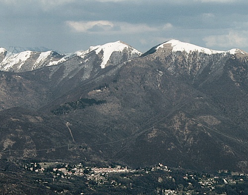
Думенца (Dumenza, Dumenza)
.svg)
- коммуна Италии
 Hiking in Думенца
Dumenza is a charming town located in the Lombardy region of Italy, near the border with Switzerland. It's situated in a picturesque area that offers a variety of hiking opportunities, particularly due to its proximity to the beautiful Val Veddasca and Lake Maggiore.
Hiking Trails and Features
-
Val Veddasca Trails:
- This valley features several trails that vary in difficulty, catering to both beginners and experienced hikers. The trails often wind through lush forests, offering stunning views of the surrounding mountains and valleys.
- Look for trails that lead to vantage points where you can take in breathtaking views of Lake Maggiore.
-
Historical Paths:
- Some trails in the area have historical significance, often leading to ancient villages, churches, and sites of cultural interest. Exploring these paths can provide insight into the region’s history and heritage.
-
Nature and Wildlife:
- Hikers can expect to encounter rich biodiversity, including various flora and fauna. Be on the lookout for unique plants and bird species native to the area.
-
Access to the Italian-Swiss Border:
- Dumenza's location allows for cross-border hikes into Switzerland. The nearby trails can take you into the Swiss Alps, where you can experience even more spectacular landscapes.
Practical Considerations
- Best Time to Hike: Late spring through early autumn is ideal for hiking in the region, as the weather is generally mild and the trails are accessible.
- Equipment: Ensure you have proper hiking gear, including sturdy footwear, weather-appropriate clothing, and essentials like water, snacks, a map, and a first-aid kit.
- Local Regulations: Familiarize yourself with local hiking regulations, particularly if you plan to venture into protected areas.
Local Amenities
- Dumenza offers various accommodations, restaurants, and shops where you can rest and refuel after your hikes. Be sure to try local cuisine for an authentic experience.
Conclusion
Whether you're seeking leisurely walks or more challenging hikes, Dumenza and its surroundings offer excellent opportunities to immerse yourself in nature. Always remember to respect the environment and follow Leave No Trace principles to help keep the trails beautiful for everyone. Enjoy your hiking adventure!
- Страна:

- Почтовый код: 21010
- Телефонный код: 0332
- Код автомобильного номера: VA
- Координаты: 46° 1' 0" N, 8° 47' 0" E


- GPS треки (wikiloc): [Ссылка]
- Высота над уровнем моря: 411 м m
- Площадь: 18.4 кв.км
- Население: 1484
- Веб сайт: http://www.comune.dumenza.va.it
- Википедия русская: wiki(ru)
- Википедия английская: wiki(en)
- Википедия национальная: wiki(it)
- Хранилище Wikidata: Wikidata: Q41052
- Катеория в википедии: [Ссылка]
- код Freebase: [/m/0ghyw6]
- код GeoNames: Альт: [6539778]
- код VIAF: Альт: [134740005]
- ID отношения в OpenStreetMap: [46749]
- код GND: Альт: [10369524-2]
- код ISTAT: 012065
- кадастровый код Италии: D384
Граничит с регионами:
Maccagno con Pino e Veddasca
- коммуна Италии
Hiking in Maccagno con Pino e Veddasca
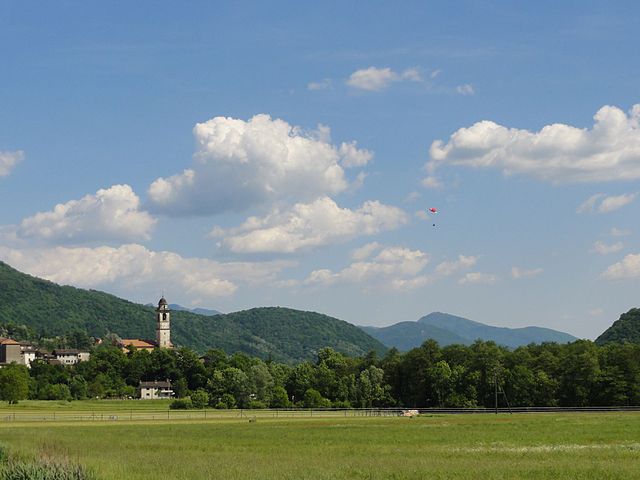
Maccagno con Pino e Veddasca is a charming municipality located in the province of Varese, Lombardy, Italy. Nestled near Lake Maggiore, it offers a diverse range of hiking opportunities, showcasing stunning views, natural beauty, and cultural heritage....
- Страна:
- Почтовый код: 21061
- Телефонный код: 0332
- Код автомобильного номера: VA
- Координаты: 46° 3' 0" N, 8° 44' 0" E
- GPS треки (wikiloc): [Ссылка]
- Высота над уровнем моря: 210 м m
- Площадь: 41.96 кв.км
- Население: 2585
- Веб сайт: [Ссылка]
Агра
- коммуна в провинции Варезе, регион Ломбардия, Италия
Hiking in Агра
Agra, a small village located in the Lombardy region of northern Italy, is known for its picturesque landscapes and historic charm. While it may not be as popular as other hiking destinations in the area, it offers several opportunities for outdoor enthusiasts and nature lovers....
- Страна:
- Почтовый код: 21010
- Телефонный код: 0332
- Код автомобильного номера: VA
- Координаты: 46° 2' 6" N, 8° 46' 18" E
- GPS треки (wikiloc): [Ссылка]
- Высота над уровнем моря: 650 м m
- Площадь: 3 кв.км
- Население: 412
- Веб сайт: [Ссылка]


Луино
- коммуна Италии
Hiking in Луино
Luino is a charming town located on the eastern shore of Lake Maggiore in the Lombardy region of Italy. It offers a variety of hiking opportunities, thanks to its stunning natural scenery, including mountains, lakes, and forests. Here are a few notable aspects of hiking in and around Luino:...
- Страна:
- Почтовый код: 21016
- Телефонный код: 0332
- Код автомобильного номера: VA
- Координаты: 46° 0' 0" N, 8° 45' 0" E
- GPS треки (wikiloc): [Ссылка]
- Высота над уровнем моря: 202 м m
- Площадь: 21.01 кв.км
- Население: 14664
- Веб сайт: [Ссылка]


Курилья-кон-Монтевьяско
- коммуна Италии
Hiking in Курилья-кон-Монтевьяско
Curiglia con Monteviasco, located in the Lombardy region of Italy, is a picturesque area that offers a variety of hiking opportunities amidst stunning natural scenery. The region is characterized by lush forests, scenic landscapes, and stunning views of Lake Lugano and the surrounding mountains. Here are some key points about hiking in this area:...
- Страна:
- Почтовый код: 21010
- Телефонный код: 0332
- Код автомобильного номера: VA
- Координаты: 46° 3' 0" N, 8° 48' 0" E
- GPS треки (wikiloc): [Ссылка]
- Высота над уровнем моря: 670 м m
- Площадь: 10.85 кв.км
- Население: 175
- Веб сайт: [Ссылка]
Monteggio
Hiking in Monteggio
Monteggio, located in the Italian region of Ticino, offers a beautiful setting for hiking enthusiasts. Nestled among the stunning landscapes of the Swiss Alps, this area is known for its diverse trails that range from easy walks to more challenging hikes....
- Страна:

- Почтовый код: 6996
- Телефонный код: 091
- Код автомобильного номера: TI
- Координаты: 46° 0' 0" N, 8° 49' 0" E
- GPS треки (wikiloc): [Ссылка]
- Высота над уровнем моря: 420 м m
- Площадь: 3.4 кв.км
- Население: 891
- Веб сайт: [Ссылка]

Novaggio
Hiking in Novaggio
Novaggio is a charming municipality located in the canton of Ticino in southern Switzerland, known for its beautiful landscapes and great hiking opportunities. It is situated near the picturesque Lake Lugano and surrounded by the foothills of the Swiss Alps, making it an excellent destination for outdoor enthusiasts....
- Страна:
- Почтовый код: 6986
- Телефонный код: 091
- Код автомобильного номера: TI
- Координаты: 46° 1' 7" N, 8° 50' 42" E
- GPS треки (wikiloc): [Ссылка]
- Высота над уровнем моря: 833 м m
- Площадь: 4.4 кв.км
- Население: 829
- Веб сайт: [Ссылка]

Сесса
Hiking in Сесса
Sessa, located in the Ticino region of Switzerland, is a beautiful destination for hiking enthusiasts. Nestled in the foothills of the Swiss Alps, it offers a mix of scenic views, charming landscapes, and a variety of trails suitable for different levels of hikers. Here are some highlights and tips for hiking in Sessa:...
- Страна:
- Почтовый код: 6997
- Телефонный код: 091
- Код автомобильного номера: TI
- Координаты: 46° 0' 0" N, 8° 49' 0" E
- GPS треки (wikiloc): [Ссылка]
- Высота над уровнем моря: 481 м m
- Площадь: 3.4 кв.км
- Население: 682
- Веб сайт: [Ссылка]


Miglieglia
Hiking in Miglieglia
Miglieglia is a picturesque village located in the Ticino region of Switzerland, nestled in the foothills of the Swiss Alps. It’s an excellent destination for hiking enthusiasts due to its beautiful landscapes, varied terrain, and stunning views. Here’s an overview of hiking in Miglieglia:...
- Страна:
- Почтовый код: 6986
- Телефонный код: 091
- Код автомобильного номера: TI
- Координаты: 46° 1' 53" N, 8° 50' 58" E
- GPS треки (wikiloc): [Ссылка]
- Высота над уровнем моря: 971 м m
- Площадь: 5.13 кв.км
- Население: 311
- Веб сайт: [Ссылка]


Astano
Hiking in Astano
Astano is a charming municipality located in the canton of Ticino in Switzerland, known for its picturesque landscape, serene environment, and proximity to Lake Lugano. While it may not be as well-known as some other destinations in Switzerland, it offers some beautiful hiking opportunities for both casual walkers and more experienced hikers....
- Страна:
- Почтовый код: 6999
- Телефонный код: 091
- Код автомобильного номера: TI
- Координаты: 46° 0' 45" N, 8° 48' 59" E
- GPS треки (wikiloc): [Ссылка]
- Высота над уровнем моря: 631 м m
- Площадь: 3.8 кв.км
- Население: 303
- Веб сайт: [Ссылка]