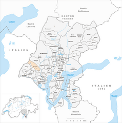
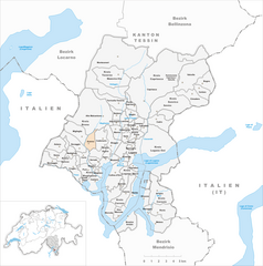
Miglieglia (Miglieglia)

 Hiking in Miglieglia
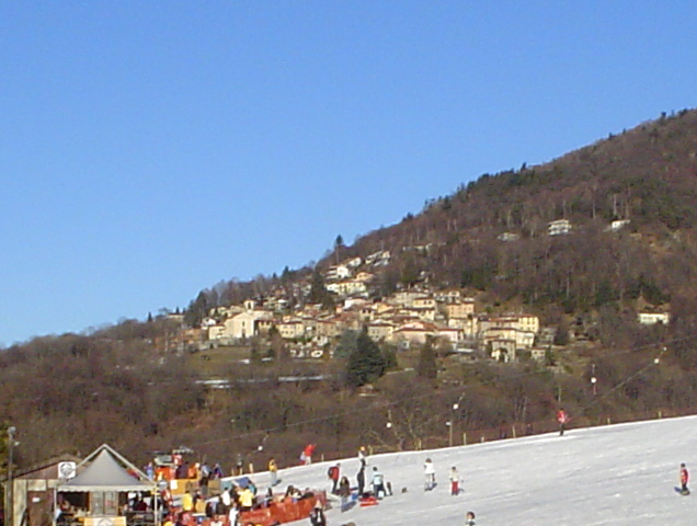
Miglieglia is a picturesque village located in the Ticino region of Switzerland, nestled in the foothills of the Swiss Alps. It’s an excellent destination for hiking enthusiasts due to its beautiful landscapes, varied terrain, and stunning views. Here’s an overview of hiking in Miglieglia:
1. Trails and Routes
Miglieglia is connected to several hiking trails that range in difficulty. Popular routes include:
-
The Serpentine Trail: This moderate trail leads you through lush forests and offers glimpses of local wildlife. The path winds along the hills, providing an excellent workout and panoramic views of the surrounding valleys.
-
The Alpe Foppa Trail: A more challenging path, this route takes you up to Alpe Foppa, where you can enjoy breathtaking views. The elevation gain provides a great sense of accomplishment as you reach higher altitudes.
-
The San Salvatore Trail: This trail leads you to the summit of Mount San Salvatore, which is accessible via a funicular as well. The hike is a bit strenuous but is well worth it for the incredible views of Lake Lugano and the surrounding mountains.
2. Scenic Views
Hiking in Miglieglia allows you to experience some of the most beautiful landscapes in Switzerland. From rolling hills and verdant forests to stunning mountain vistas, the region's natural beauty is captivating.
3. Flora and Fauna
The area is rich in biodiversity, featuring a mix of alpine and subtropical plants, as well as a variety of wildlife. Keep an eye out for local fauna, including deer, numerous bird species, and perhaps even the occasional hedgehog.
4. Accessibility
Miglieglia is easily accessible by public transportation from larger cities like Lugano. This makes it a convenient location for day hikes or a weekend getaway.
5. Best Time to Visit
The best time for hiking in Miglieglia is from late spring to early autumn (approximately May to September), when the weather is mild and the trails are free of snow. However, it’s important to check local weather conditions before heading out, as they can change rapidly in mountain areas.
6. Recommendations
- Gear Up: Wear appropriate hiking gear, including sturdy boots, weather-appropriate clothing, and bring enough water and snacks.
- Maps and Guides: It's a good idea to carry a topographic map or use a reliable hiking app to ensure you stay on track.
- Respect Nature: As always, follow the Leave No Trace principles to protect the environment and preserve the beauty of the trails for future visitors.
Miglieglia offers an authentic Swiss hiking experience with trails that cater to all levels of hikers. Enjoy the stunning scenery and the peace that comes with being in nature!
- Страна:

- Почтовый код: 6986
- Телефонный код: 091
- Код автомобильного номера: TI
- Координаты: 46° 1' 53" N, 8° 50' 58" E


- GPS треки (wikiloc): [Ссылка]
- Высота над уровнем моря: 971 м m
- Площадь: 5.13 кв.км
- Население: 311
- Веб сайт: http://www.miglieglia.ch
- Википедия английская: wiki(en)
- Википедия национальная: wiki(de)
- Хранилище Wikidata: Wikidata: Q70129
- Катеория в википедии: [Ссылка]
- код Freebase: [/m/0gzspd]
- код GeoNames: Альт: [7286508]
- код VIAF: Альт: [245439881]
- ID отношения в OpenStreetMap: [1684716]
- код GND: Альт: [7526314-2]
- идентификатор местоположения ArchINFORM: [42777]
- идентификатор HDS: [2185]
- код швейцарского муниципалитета: [5200]
Граничит с регионами:


Курилья-кон-Монтевьяско
- коммуна Италии
Hiking in Курилья-кон-Монтевьяско
Curiglia con Monteviasco, located in the Lombardy region of Italy, is a picturesque area that offers a variety of hiking opportunities amidst stunning natural scenery. The region is characterized by lush forests, scenic landscapes, and stunning views of Lake Lugano and the surrounding mountains. Here are some key points about hiking in this area:...
- Страна:

- Почтовый код: 21010
- Телефонный код: 0332
- Код автомобильного номера: VA
- Координаты: 46° 3' 0" N, 8° 48' 0" E
- GPS треки (wikiloc): [Ссылка]
- Высота над уровнем моря: 670 м m
- Площадь: 10.85 кв.км
- Население: 175
- Веб сайт: [Ссылка]
Думенца
- коммуна Италии
Hiking in Думенца
Dumenza is a charming town located in the Lombardy region of Italy, near the border with Switzerland. It's situated in a picturesque area that offers a variety of hiking opportunities, particularly due to its proximity to the beautiful Val Veddasca and Lake Maggiore....
- Страна:
- Почтовый код: 21010
- Телефонный код: 0332
- Код автомобильного номера: VA
- Координаты: 46° 1' 0" N, 8° 47' 0" E
- GPS треки (wikiloc): [Ссылка]
- Высота над уровнем моря: 411 м m
- Площадь: 18.4 кв.км
- Население: 1484
- Веб сайт: [Ссылка]


Alto Malcantone
Hiking in Alto Malcantone
Alto Malcantone is a beautiful region in the Canton of Ticino, Switzerland, known for its stunning landscapes, serene forests, and picturesque villages. The area offers a variety of hiking trails suitable for different skill levels, making it a great destination for both novice and experienced hikers. Here are some key points to consider if you’re planning a hike in Alto Malcantone:...
- Страна:
- Почтовый код: 6939
- Телефонный код: 91
- Код автомобильного номера: TI
- Координаты: 46° 2' 0" N, 8° 53' 0" E
- GPS треки (wikiloc): [Ссылка]
- Высота над уровнем моря: 810 м m
- Площадь: 22.1 кв.км
- Население: 1405
- Веб сайт: [Ссылка]

Novaggio
Hiking in Novaggio
Novaggio is a charming municipality located in the canton of Ticino in southern Switzerland, known for its beautiful landscapes and great hiking opportunities. It is situated near the picturesque Lake Lugano and surrounded by the foothills of the Swiss Alps, making it an excellent destination for outdoor enthusiasts....
- Страна:
- Почтовый код: 6986
- Телефонный код: 091
- Код автомобильного номера: TI
- Координаты: 46° 1' 7" N, 8° 50' 42" E
- GPS треки (wikiloc): [Ссылка]
- Высота над уровнем моря: 833 м m
- Площадь: 4.4 кв.км
- Население: 829
- Веб сайт: [Ссылка]
Aranno
Hiking in Aranno
Aranno is a charming village located in the canton of Ticino, Switzerland. It offers a fantastic setting for hiking enthusiasts, with beautiful landscapes and a variety of trails that cater to different skill levels. Here are some key points about hiking in Aranno:...
- Страна:
- Почтовый код: 6994
- Телефонный код: 91
- Код автомобильного номера: TI
- Координаты: 46° 1' 0" N, 8° 52' 0" E
- GPS треки (wikiloc): [Ссылка]
- Высота над уровнем моря: 707 м m
- Площадь: 2.58 кв.км
- Население: 375
- Веб сайт: [Ссылка]