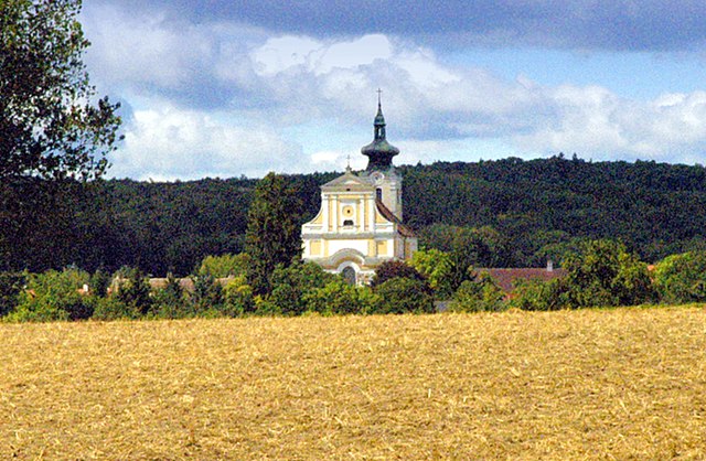
Эггенбург (Eggenburg, Eggenburg)

 Hiking in Эггенбург
Eggenburg, located in Lower Austria, offers some beautiful hiking opportunities, nestled between rolling hills and lush landscapes. Here are a few highlights and tips for hiking in this region:
Trails and Routes
-
Eggenburg Circular Hiking Trail: This trail takes you through the scenic countryside, allowing you to explore local flora and fauna while enjoying panoramic views of the surrounding hills. It typically covers a distance of around 10-15 km and is suitable for various fitness levels.
-
The Waldviertel Region: Eggenburg is part of the Waldviertel, known for its dense forests and charming villages. There are numerous hiking paths that connect to other small towns, giving hikers the chance to experience the region’s cultural heritage.
-
Nature Parks: Nearby nature parks, such as the Naturpark blockheide, offer well-marked trails ranging from easy walks to more challenging hikes. The diverse landscape includes rocky formations, meadows, and forests.
Highlights
- Historical Sites: Along your hike, you may encounter historical landmarks, such as the Eggenburg castle ruins and charming traditional farmhouses, which add cultural value to your journey.
- Scenic Views: Many trails in the area lead to vantage points where you can overlook the vast landscapes of Lower Austria, especially beautiful during sunrise or sunset.
Seasons and Weather
- Best Time to Hike: Spring (April to June) and autumn (September to October) are ideal for hiking, as temperatures are mild and the scenery is particularly beautiful with blooming flowers or fall foliage.
- Winter Hiking: If you're into winter sports, some trails may also be accessible for winter hiking, but check local conditions and ensure you have appropriate gear.
Tips
- Trail Maps: It’s advisable to carry a detailed map or a GPS device, as some trails can be poorly marked.
- Local Guides: Consider joining a local hiking group or hiring a guide if you want to learn more about the region's natural and cultural history.
- Gear: Sturdy hiking boots, weather-appropriate clothing, plenty of water, and snacks are essential for a comfortable hike.
Conclusion
Hiking in Eggenburg can be a rewarding experience, offering both natural beauty and a touch of historical charm. Whether you're a casual walker or an experienced hiker, there's something for everyone in this picturesque part of Lower Austria.
- Страна:

- Почтовый код: 3730
- Телефонный код: 02984
- Код автомобильного номера: HO
- Координаты: 48° 38' 35" N, 15° 49' 7" E


- GPS треки (wikiloc): [Ссылка]
- Высота над уровнем моря: 329 м m
- Площадь: 23.52 кв.км
- Население: 3540
- Веб сайт: http://www.eggenburg.gv.at
- Википедия русская: wiki(ru)
- Википедия английская: wiki(en)
- Википедия национальная: wiki(de)
- Хранилище Wikidata: Wikidata: Q661774
- Галерея изображений в википедии: [Ссылка]
- Катеория в википедии: [Ссылка]
- код Freebase: [/m/02qx8km]
- код GeoNames: Альт: [2780360]
- код VIAF: Альт: [139013705]
- код GND: Альт: [4013604-8]
- идентификатор местоположения ArchINFORM: [10060]
- код LCNAF: Альт: [n92112833]
- WOEID: [541466]
- код темы Quora: [Eggenburg]
- код австрийского муниципалитета: [31105]
- код Цифрового атласа Римской империи: [23109]
- код Pleiades: [118659]
Граничит с регионами:
Штранинг-Графенберг
Hiking in Штранинг-Графенберг
Straning-Grafenberg is located in Austria and offers beautiful hiking opportunities, particularly in the surrounding areas of the Austrian Alps. Here are some highlights and tips for hiking in this region:...
- Страна:
- Почтовый код: 3722
- Телефонный код: 02984
- Код автомобильного номера: HO
- Координаты: 48° 37' 14" N, 15° 51' 24" E
- GPS треки (wikiloc): [Ссылка]
- Высота над уровнем моря: 292 м m
- Площадь: 26.47 кв.км
- Население: 781
- Веб сайт: [Ссылка]

Майзельдорф
Hiking in Майзельдорф
Meiseldorf is a beautiful village located in the Lower Austria region of Austria. While it may not be as widely recognized as some of the larger hiking areas in the Alps, it offers serene trails and scenic views that are perfect for outdoor enthusiasts....
- Страна:
- Почтовый код: 3744
- Телефонный код: 02983
- Код автомобильного номера: HO
- Координаты: 48° 39' 53" N, 15° 45' 6" E
- GPS треки (wikiloc): [Ссылка]
- Высота над уровнем моря: 398 м m
- Площадь: 35.45 кв.км
- Население: 876
- Веб сайт: [Ссылка]

Бургшлайниц-Кюнринг
Hiking in Бургшлайниц-Кюнринг
Burgschleinitz-Kühnring, located in Lower Austria, is a picturesque area with varied terrain that offers a range of hiking opportunities. Here are some highlights to consider when planning a hike in this region:...
- Страна:
- Телефонный код: 02984
- Код автомобильного номера: HO
- Координаты: 48° 36' 27" N, 15° 49' 0" E
- GPS треки (wikiloc): [Ссылка]
- Высота над уровнем моря: 376 м m
- Площадь: 41.84 кв.км
- Население: 1360
- Веб сайт: [Ссылка]

Рёшиц
Hiking in Рёшиц
Röschitz is a charming village located in the Lower Austria region of Austria, surrounded by picturesque landscapes that are perfect for hiking enthusiasts. The area is known for its rolling hills, vineyards, and lush natural surroundings, making it an ideal destination for both novice and experienced hikers....
- Страна:
- Почтовый код: 3743
- Телефонный код: 02984
- Код автомобильного номера: HO
- Координаты: 48° 40' 0" N, 15° 53' 0" E
- GPS треки (wikiloc): [Ссылка]
- Высота над уровнем моря: 280 м m
- Площадь: 21.16 кв.км
- Население: 1052
- Веб сайт: [Ссылка]