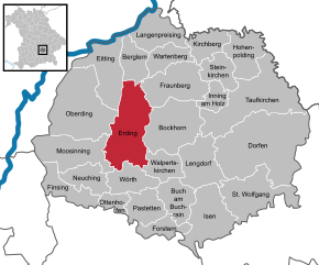
Эрдинг (District of Erding, Landkreis Erding)

- район Баварии
 Hiking in Эрдинг
Erding, located in Bavaria, Germany, offers a variety of hiking opportunities for enthusiasts of all skill levels. This district is characterized by its beautiful landscapes, rolling hills, and picturesque villages, making it a wonderful destination for outdoor activities.
Hiking Trails in Erding
-
Erding's Nature Trails: The district has several dedicated nature trails that allow hikers to explore the local flora and fauna. These trails are typically well-marked and range from easy to moderate difficulty.
-
Isar River Trails: Following the Isar River, you can enjoy scenic walks along the banks, taking in the serene landscape and possibly encountering wildlife.
-
Regional Park Trails: Nearby regional parks and nature reserves often have designated trails that showcase the natural beauty of the area. Check for local parks that offer thematic trails focusing on nature or history.
Nearby Hiking Areas
- Bavarian Moor Nature Reserve: Just outside Erding, this area features wetlands and unique ecosystems, offering tranquil hiking experiences.
- The Aufhausen Loop: A popular circular route that takes you through charming Bavarian landscapes and traditional villages.
Tips for Hiking in Erding
- Prepare Properly: Check the weather forecast and dress in layers, as the temperature can change while hiking. Sturdy footwear is essential.
- Hydration: Carry enough water, especially during warmer months.
- Maps and Navigation: While many trails are well-marked, having a local map or GPS app could help with navigation.
- Respect Nature: Stay on marked paths, take your trash with you, and respect local wildlife.
Best Time to Hike
The best months for hiking in the Erding district are typically late spring to early autumn (May to October) when the weather is pleasant, and the trails are most accessible.
Amenities
In Erding, you’ll find plenty of places to eat and rest. Local gasthaus and cafes provide traditional Bavarian food, making it a great way to relax after a day of hiking.
Whether you are looking for a short day hike or a longer trek, the Erding district has something to offer every hiking enthusiast. Enjoy the natural beauty of Bavaria!
- Страна:

- Код автомобильного номера: ED
- Координаты: 48° 19' 48" N, 11° 55' 12" E


- GPS треки (wikiloc): [Ссылка]
- Высота над уровнем моря: 480 м m
- Площадь: 870.44 кв.км
- Население: 89190
- Веб сайт: http://www.landkreis-erding.de/
- Википедия русская: wiki(ru)
- Википедия английская: wiki(en)
- Википедия национальная: wiki(de)
- Хранилище Wikidata: Wikidata: Q10539
- Катеория в википедии: [Ссылка]
- код Freebase: [/m/01n00b]
- код GeoNames: Альт: [2929716]
- код VIAF: Альт: [244042577]
- ID отношения в OpenStreetMap: [62356]
- код GND: Альт: [4015165-7]
- идентификатор местоположения ArchINFORM: [5683]
- код LCNAF: Альт: [n82088578]
- код темы Quora: [Erding]
- код TGN: [7188728]
- код Historical Gazetteer: [adm_139177]
- Bavarikon ID: [ODB_A00002347]
- код ISNI: Альт: [0000 0004 0582 149X]
- код NUTS: [DE21A]
- код BabelNet: [01985567n]
- код района Германии: 09177
Включает регионы:

Изен
Hiking in Изен
Isen, a small town in Bavaria, Germany, offers a picturesque setting for hiking enthusiasts. Located near the foothills of the Alps and surrounded by beautiful landscapes, Isen provides access to a variety of trails suitable for different skill levels. Here are some key points to consider when hiking in this area:...
- Страна:
- Почтовый код: 84424
- Телефонный код: 08083
- Код автомобильного номера: ED
- Координаты: 48° 13' 0" N, 12° 4' 0" E
- GPS треки (wikiloc): [Ссылка]
- Высота над уровнем моря: 536 м m
- Площадь: 43.78 кв.км
- Население: 5832
- Веб сайт: [Ссылка]
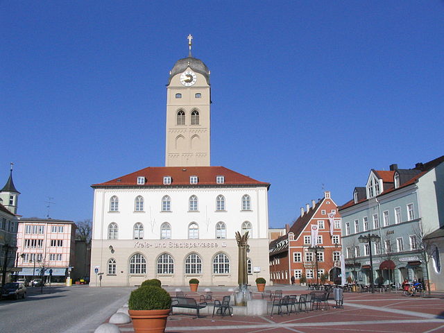
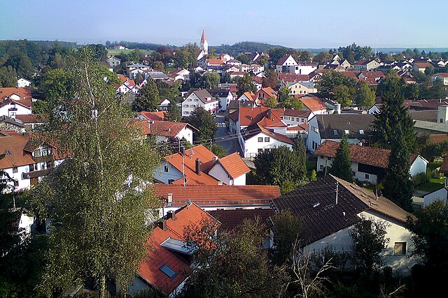
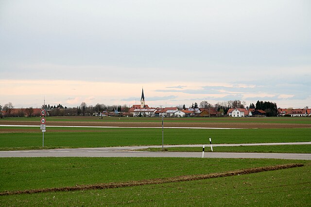
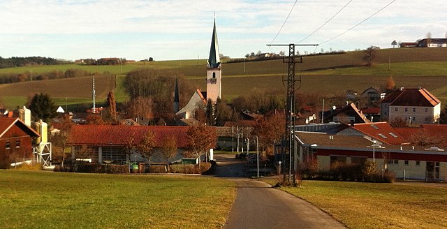
Эрдинг
Hiking in Эрдинг
Erding, located in Bavaria, Germany, is well-known for its picturesque landscapes, making it a great base for hiking enthusiasts. While Erding itself is a small city, it is surrounded by beautiful countryside and forests that offer various trails catering to different skill levels. Here are some aspects to consider when hiking in and around Erding:...
- Страна:
- Почтовый код: 85435
- Телефонный код: 08122
- Код автомобильного номера: ED
- Координаты: 48° 18' 0" N, 11° 54' 30" E
- GPS треки (wikiloc): [Ссылка]
- Высота над уровнем моря: 469 м m
- Площадь: 54.64 кв.км
- Население: 36291
- Веб сайт: [Ссылка]

Обердинг
Hiking in Обердинг
Oberding, located in Bavaria, Germany, offers a variety of outdoor activities, including hiking, thanks to its picturesque landscapes and proximity to nature. While it is not as well-known as some of the larger national parks or mountain areas in Bavaria, it provides a peaceful environment for hikers....
- Страна:
- Почтовый код: 85445
- Телефонный код: 08122
- Код автомобильного номера: ED
- Координаты: 48° 19' 0" N, 11° 51' 0" E
- GPS треки (wikiloc): [Ссылка]
- Высота над уровнем моря: 468 м m
- Площадь: 64.72 кв.км
- Население: 6280
- Веб сайт: [Ссылка]

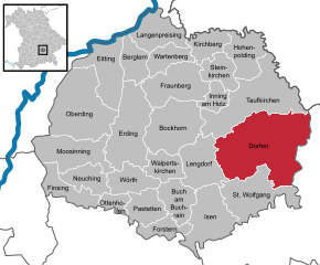
Дорфен
Hiking in Дорфен
Dorfen, located in Bavaria, Germany, is a charming town that offers access to various hiking opportunities in the surrounding countryside. Here are some highlights for hiking in and around Dorfen:...
- Страна:
- Почтовый код: 84405
- Телефонный код: 08081
- Код автомобильного номера: ED
- Координаты: 48° 16' 15" N, 12° 9' 7" E
- GPS треки (wikiloc): [Ссылка]
- Высота над уровнем моря: 442 м m
- Площадь: 99.60 кв.км
- Население: 14407
- Веб сайт: [Ссылка]


Фраунберг
Hiking in Фраунберг
Fraunberg is a small region in Bavaria, Germany, and while it may not be as famous as other hiking destinations in the country, it offers beautiful landscapes and a charming countryside setting for outdoor enthusiasts....
- Страна:
- Почтовый код: 85447
- Телефонный код: 08762
- Код автомобильного номера: ED
- Координаты: 48° 22' 0" N, 12° 0' 0" E
- GPS треки (wikiloc): [Ссылка]
- Высота над уровнем моря: 444 м m
- Площадь: 42.37 кв.км
- Население: 3537
- Веб сайт: [Ссылка]

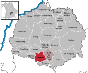
Паштеттен
Hiking in Паштеттен
Pastetten is a charming village located in Bavaria, Germany, and while it's not a major hiking destination compared to larger mountain ranges, it does offer some delightful walking and hiking opportunities, especially for those looking to enjoy the scenic countryside....
- Страна:
- Почтовый код: 85669
- Телефонный код: 08124
- Код автомобильного номера: ED
- Координаты: 48° 12' 0" N, 11° 57' 0" E
- GPS треки (wikiloc): [Ссылка]
- Высота над уровнем моря: 506 м m
- Площадь: 22.05 кв.км
- Население: 1308
- Веб сайт: [Ссылка]

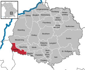
Финзинг
Hiking in Финзинг
Finsing, a small town in Bavaria, Germany, is surrounded by beautiful landscapes that offer opportunities for hiking and outdoor activities. While it may not be a well-known hiking destination, there are several scenic routes and local trails nearby....
- Страна:
- Почтовый код: 85464
- Телефонный код: 08121
- Код автомобильного номера: ED
- Координаты: 48° 13' 0" N, 11° 50' 0" E
- GPS треки (wikiloc): [Ссылка]
- Высота над уровнем моря: 492 м m
- Площадь: 23.17 кв.км
- Население: 1961
- Веб сайт: [Ссылка]


Мозиннинг
Hiking in Мозиннинг
Moosinning, a small town in Bavaria, Germany, is not particularly famous for hiking compared to larger natural parks or mountainous regions, but it does have nearby areas and trails that are suitable for walking and exploring nature. Here are some points to consider if you're planning to hike in and around Moosinning:...
- Страна:
- Почтовый код: 85452
- Телефонный код: 08123
- Код автомобильного номера: ED
- Координаты: 48° 17' 0" N, 11° 51' 0" E
- GPS треки (wikiloc): [Ссылка]
- Высота над уровнем моря: 489 м m
- Площадь: 39.96 кв.км
- Население: 2899
- Веб сайт: [Ссылка]


Берглерн
Hiking in Берглерн
Berglern, a small municipality in Bavaria, Germany, is not widely known for extensive hiking trails compared to larger national parks or mountainous regions. However, it’s situated in a beautiful rural area that offers a range of outdoor activities, including local walking and hiking options....
- Страна:
- Почтовый код: 85459
- Телефонный код: 08762
- Код автомобильного номера: ED
- Координаты: 48° 23' 0" N, 11° 56' 0" E
- GPS треки (wikiloc): [Ссылка]
- Высота над уровнем моря: 440 м m
- Площадь: 19.89 кв.км
- Население: 1007
- Веб сайт: [Ссылка]

Оттенхофен
Hiking in Оттенхофен
Ottenhofen is a small town in Bavaria, Germany, surrounded by picturesque landscapes, making it a great spot for hiking enthusiasts. While specific trails may vary, here are some general insights about hiking in and around Ottenhofen:...
- Страна:
- Почтовый код: 85570
- Телефонный код: 08121
- Код автомобильного номера: ED
- Координаты: 48° 13' 0" N, 11° 53' 0" E
- GPS треки (wikiloc): [Ссылка]
- Высота над уровнем моря: 498 м m
- Площадь: 10.27 кв.км
- Население: 1040
- Веб сайт: [Ссылка]

Форстерн
Hiking in Форстерн
Forstern is a small municipality located in Bavaria, Germany, near the city of Erding. While it's not as widely known for hiking as some of the larger national parks or mountainous regions in Germany, there are still opportunities to enjoy nature and explore the local landscape....
- Страна:
- Почтовый код: 85659
- Телефонный код: 08124
- Код автомобильного номера: ED
- Координаты: 48° 11' 0" N, 11° 59' 0" E
- GPS треки (wikiloc): [Ссылка]
- Высота над уровнем моря: 520 м m
- Площадь: 15.38 кв.км
- Население: 1591
- Веб сайт: [Ссылка]


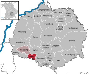
Нойхинг
Hiking in Нойхинг
Hiking in Neuchâtel, Switzerland, offers stunning landscapes and a variety of trails for all levels of hikers. The region is known for its beautiful lakes, rolling hills, vineyards, and proximity to the Jura Mountains. Here are some highlights of hiking in and around Neuchâtel:...
- Страна:
- Почтовый код: 85467
- Телефонный код: 08123
- Код автомобильного номера: ED
- Координаты: 48° 14' 0" N, 11° 51' 0" E
- GPS треки (wikiloc): [Ссылка]
- Высота над уровнем моря: 495 м m
- Площадь: 19.66 кв.км
- Население: 2427
- Веб сайт: [Ссылка]


Иннинг-ам-Хольц
Hiking in Иннинг-ам-Хольц
Inning am Holz is a picturesque area located in Bavaria, Germany, known for its beautiful landscapes and outdoor activities, including hiking. The region is characterized by a mix of lush forests, rolling hills, and views of nearby lakes, making it an excellent destination for both novice and experienced hikers....
- Страна:
- Почтовый код: 84416
- Телефонный код: 08084
- Код автомобильного номера: ED
- Координаты: 48° 21' 0" N, 12° 5' 0" E
- GPS треки (wikiloc): [Ссылка]
- Высота над уровнем моря: 491 м m
- Площадь: 11.83 кв.км
- Население: 716
- Веб сайт: [Ссылка]


Хоэнпольдинг
Hiking in Хоэнпольдинг
Hohenpolding, located in Bavaria, Germany, is a charming area for hiking enthusiasts. The region offers a variety of picturesque trails that showcase the beautiful Bavarian landscape, featuring rolling hills, meadows, forests, and panoramic views of the Alps. Here are some key points to consider if you're planning a hiking trip to Hohenpolding:...
- Страна:
- Почтовый код: 84432
- Телефонный код: 08084
- Код автомобильного номера: ED
- Координаты: 48° 23' 4" N, 12° 7' 55" E
- GPS треки (wikiloc): [Ссылка]
- Высота над уровнем моря: 488 м m
- Площадь: 27.42 кв.км
- Население: 1128
- Веб сайт: [Ссылка]


Айттинг
Hiking in Айттинг
Eitting is a small town located in Bavaria, Germany, near Munich. While Eitting itself might not be a well-known hiking destination, it is conveniently situated close to several beautiful natural areas and hiking trails that offer scenic views and enjoyable outdoor experiences. Here are some aspects to consider when thinking about hiking in and around Eitting:...
- Страна:
- Почтовый код: 85462
- Телефонный код: 08122
- Код автомобильного номера: ED
- Координаты: 48° 21' 35" N, 11° 53' 31" E
- GPS треки (wikiloc): [Ссылка]
- Высота над уровнем моря: 451 м m
- Площадь: 35.63 кв.км
- Население: 1458
- Веб сайт: [Ссылка]


Бух-ам-Бухрайн
Hiking in Бух-ам-Бухрайн
Buch am Buchrain is a small community located in Bavaria, Germany, known for its beautiful natural surroundings and access to outdoor activities, including hiking. The region features scenic landscapes, including forests, meadows, and rolling hills, making it a great spot for hikers of all levels....
- Страна:
- Почтовый код: 85656
- Телефонный код: 08124
- Код автомобильного номера: ED
- Координаты: 48° 13' 0" N, 12° 0' 0" E
- GPS треки (wikiloc): [Ссылка]
- Высота над уровнем моря: 538 м m
- Площадь: 22.75 кв.км
- Население: 812
- Веб сайт: [Ссылка]


Кирхберг
- муниципалитет в Германии, Бавария
Hiking in Кирхберг
Kirchberg, located in Upper Bavaria, is a beautiful destination for hiking enthusiasts. Nestled in the foothills of the Alps, it offers a variety of trails suitable for different skill levels, making it an ideal spot for both beginners and experienced hikers....
- Страна:
- Почтовый код: 84434
- Телефонный код: 08762; 08706
- Код автомобильного номера: ED
- Координаты: 48° 24' 0" N, 12° 3' 0" E
- GPS треки (wikiloc): [Ссылка]
- Высота над уровнем моря: 519 м m
- Площадь: 17.09 кв.км
- Население: 780
- Веб сайт: [Ссылка]


Ленгдорф
Hiking in Ленгдорф
Lengdorf is a quaint village located in Bavaria, Germany. While it may not be as widely known as some of the larger hiking destinations, it offers beautiful landscapes and a peaceful environment that can be quite appealing for hiking enthusiasts. Here are some tips and information about hiking in and around Lengdorf:...
- Страна:
- Почтовый код: 84435
- Телефонный код: 08083
- Код автомобильного номера: ED
- Координаты: 48° 16' 0" N, 12° 3' 0" E
- GPS треки (wikiloc): [Ссылка]
- Высота над уровнем моря: 473 м m
- Площадь: 33.90 кв.км
- Население: 2706
- Веб сайт: [Ссылка]

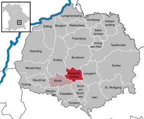
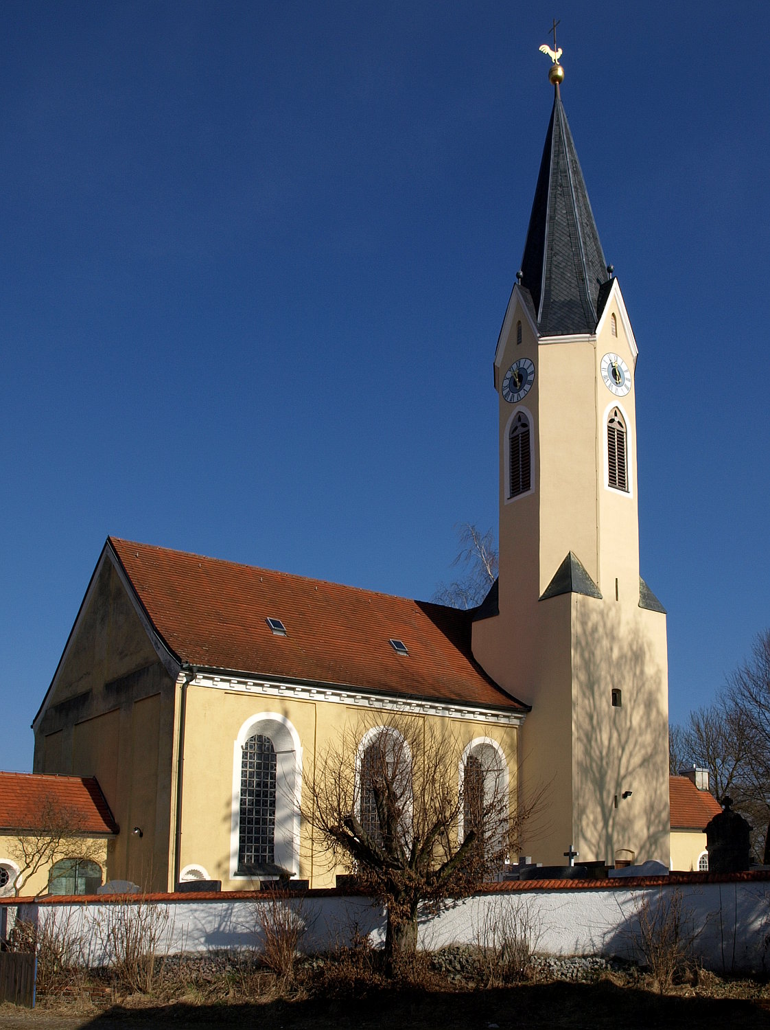
Вальпертскирхен
Hiking in Вальпертскирхен
Walpertskirchen is a small municipality located in Bavaria, Germany, not far from Munich. While it may not be as famous as some larger hiking destinations, it offers access to beautiful landscapes and the charm of the Bavarian countryside....
- Страна:
- Почтовый код: 85469
- Телефонный код: 08122
- Код автомобильного номера: ED
- Координаты: 48° 15' 0" N, 11° 58' 0" E
- GPS треки (wikiloc): [Ссылка]
- Высота над уровнем моря: 499 м m
- Площадь: 18.45 кв.км
- Население: 1323
- Веб сайт: [Ссылка]

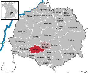
Вёрт
Hiking in Вёрт
Wörth in Upper Bavaria is a picturesque area that offers a variety of hiking opportunities for outdoor enthusiasts. This region is characterized by its diverse landscapes, including rolling hills, forests, and scenic views of the nearby mountains. Here are some highlights about hiking in Wörth:...
- Страна:
- Почтовый код: 85457
- Телефонный код: 08123; 08122
- Код автомобильного номера: ED
- Координаты: 48° 14' 0" N, 11° 54' 0" E
- GPS треки (wikiloc): [Ссылка]
- Высота над уровнем моря: 482 м m
- Площадь: 21.05 кв.км
- Население: 4437
- Веб сайт: [Ссылка]


Лангенпрайзинг
Hiking in Лангенпрайзинг
Langenpreising, located in Bavaria, Germany, is surrounded by beautiful landscapes that provide excellent opportunities for hiking. The region is characterized by gentle hills, lush forests, and agricultural fields, making it an ideal spot for both enjoyable walks and more strenuous hikes....
- Страна:
- Почтовый код: 85465
- Телефонный код: 08762
- Код автомобильного номера: ED
- Координаты: 48° 26' 0" N, 11° 58' 0" E
- GPS треки (wikiloc): [Ссылка]
- Высота над уровнем моря: 421 м m
- Площадь: 27.49 кв.км
- Население: 2641
- Веб сайт: [Ссылка]

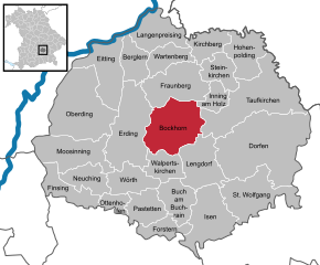
Бокхорн
Hiking in Бокхорн
Bockhorn, located in Bavaria, Germany, is surrounded by beautiful landscapes that are great for hiking. The region offers a variety of trails suitable for different skill levels, making it an excellent spot for both beginners and experienced hikers....
- Страна:
- Почтовый код: 85461
- Телефонный код: 08122
- Код автомобильного номера: ED
- Координаты: 48° 19' 0" N, 11° 59' 0" E
- GPS треки (wikiloc): [Ссылка]
- Высота над уровнем моря: 454 м m
- Площадь: 47.15 кв.км
- Население: 3631
- Веб сайт: [Ссылка]


Тауфкирхен
Hiking in Тауфкирхен
Taufkirchen (Vils) is a charming municipality located in Bavaria, Germany, known for its picturesque landscapes and proximity to the Vils River. While it's a smaller town, it offers several opportunities for hiking enthusiasts to explore the natural beauty of the Bavarian countryside....
- Страна:
- Почтовый код: 84416
- Телефонный код: 08084
- Код автомобильного номера: ED
- Координаты: 48° 20' 38" N, 12° 7' 49" E
- GPS треки (wikiloc): [Ссылка]
- Высота над уровнем моря: 491 м m
- Площадь: 70.18 кв.км
- Население: 7733
- Веб сайт: [Ссылка]
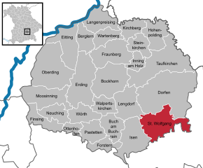
Санкт-Вольфганг
Hiking in Санкт-Вольфганг
Sankt Wolfgang, located in the beautiful Salzkammergut region of Austria, is a popular destination for hiking enthusiasts. Nestled between the stunning Wolfgangsee lake and the surrounding mountains, it offers a variety of trails that cater to different skill levels and preferences. Here are some highlights you'd find in the hiking experience around Sankt Wolfgang:...
- Страна:
- Почтовый код: 84427
- Телефонный код: 08085
- Код автомобильного номера: ED
- Координаты: 48° 13' 0" N, 12° 8' 0" E
- GPS треки (wikiloc): [Ссылка]
- Высота над уровнем моря: 525 м m
- Площадь: 46.32 кв.км
- Население: 4433
- Веб сайт: [Ссылка]


Вартенберг
Hiking in Вартенберг
Wartenberg, located in Bavaria, Germany, offers a scenic backdrop for hiking enthusiasts. The area is characterized by its rolling hills, lush forests, and picturesque countryside, making it an excellent destination for both casual walkers and more serious hikers....
- Страна:
- Почтовый код: 85456
- Телефонный код: 08762
- Код автомобильного номера: ED
- Координаты: 48° 24' 18" N, 11° 59' 20" E
- GPS треки (wikiloc): [Ссылка]
- Высота над уровнем моря: 430 м m
- Площадь: 17.88 кв.км
- Население: 3038
- Веб сайт: [Ссылка]


Штайнкирхен
Hiking in Штайнкирхен
Steinkirchen is a picturesque area located in northern Germany, surrounded by lush landscapes and natural beauty, making it a great destination for hiking enthusiasts. Here are some key points to consider if you're planning a hiking trip in Steinkirchen:...
- Страна:
- Почтовый код: 84439
- Телефонный код: 08084
- Код автомобильного номера: ED
- Координаты: 48° 23' 0" N, 12° 5' 0" E
- GPS треки (wikiloc): [Ссылка]
- Высота над уровнем моря: 493 м m
- Площадь: 18.08 кв.км
- Население: 1069
- Веб сайт: [Ссылка]
Граничит с регионами:

Ландсхут
Hiking in Ландсхут
Landshut district, located in Bavaria, Germany, offers a variety of hiking opportunities that cater to different skill levels and preferences. The landscape is characterized by rolling hills, picturesque villages, and lush forests, providing a beautiful backdrop for outdoor activities....
- Страна:
- Столица: Ландсхут
- Код автомобильного номера: LA
- Координаты: 48° 34' 14" N, 12° 10' 50" E
- GPS треки (wikiloc): [Ссылка]
- Высота над уровнем моря: 383 м m
- Площадь: 1348 кв.км
- Население: 115644
- Веб сайт: [Ссылка]

Фрайзинг
Hiking in Фрайзинг
Freising, located in Bavaria, Germany, offers a variety of hiking opportunities suitable for different skill levels and preferences. The district is known for its picturesque landscapes, including rolling hills, scenic views, and lush forests. Here are some highlights if you’re considering hiking in Freising:...
- Страна:
- Столица: Фрайзинг
- Код автомобильного номера: FS
- Координаты: 48° 30' 0" N, 11° 49' 48" E
- GPS треки (wikiloc): [Ссылка]
- Высота над уровнем моря: 433 м m
- Площадь: 800.00 кв.км
- Население: 118518
- Веб сайт: [Ссылка]

Мюльдорф-на-Инне
- район Баварии
Hiking in Мюльдорф-на-Инне
Mühldorf District, located in Bavaria, Germany, offers a range of hiking opportunities that cater to different skill levels and preferences. The area features scenic landscapes, including rolling hills, forests, and rivers, making it an attractive destination for nature lovers and outdoor enthusiasts....
- Страна:
- Столица: Мюльдорф-на-Инне
- Код автомобильного номера: MÜ
- Координаты: 48° 15' 0" N, 12° 25' 12" E
- GPS треки (wikiloc): [Ссылка]
- Высота над уровнем моря: 447 м m
- Площадь: 805.32 кв.км
- Население: 92882

Эберсберг
- район Баварии
Hiking in Эберсберг
Ebersberg District, located in Bavaria, Germany, is a fantastic destination for hiking enthusiasts. This region offers a mix of lush forests, rolling hills, picturesque landscapes, and scenic views, making it perfect for both casual walkers and more experienced hikers....
- Страна:
- Столица: Эберсберг
- Код автомобильного номера: EBE
- Координаты: 48° 4' 48" N, 11° 55' 12" E
- GPS треки (wikiloc): [Ссылка]
- Высота над уровнем моря: 601 м m
- Площадь: 549.30 кв.км
- Население: 96283
- Веб сайт: [Ссылка]

Мюнхен
- район Баварии
Hiking in Мюнхен
Hiking in and around Munich, the capital of Bavaria, offers a wonderful blend of urban landscapes and stunning natural scenery. While Munich itself is a vibrant city with parks and green spaces, many hiking opportunities are just a short distance away in the surrounding region....
- Страна:
- Столица: Мюнхен
- Телефонный код: 089
- Код автомобильного номера: WOR; M; AIB
- Координаты: 48° 0' 0" N, 11° 40' 12" E
- GPS треки (wikiloc): [Ссылка]
- Высота над уровнем моря: 513 м m
- Площадь: 52020.58 кв.км
- Население: 343405
- Веб сайт: [Ссылка]