
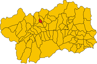
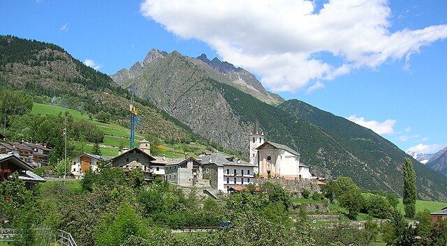
Этрубль (Etroubles, Etroubles)
.svg)
- коммуна Италии
 Hiking in Этрубль
Etroubles is a charming village located in the Aosta Valley region of Italy, known for its stunning alpine landscapes and rich cultural heritage. Hiking in and around Etroubles offers a fantastic experience for outdoor enthusiasts, with a variety of trails suitable for different skill levels.
Popular Hiking Trails:
-
Sentiero dei Forti: This trail offers a glimpse into the historical military fortifications of the area, with panoramic views of the surrounding mountains. It’s a moderate hike that combines nature with history.
-
Monte Emilius: A more challenging hike that leads you to the summit of Monte Emilius, where you can enjoy breathtaking views of the Aosta Valley. Make sure you are well-prepared with proper gear and be aware of the weather conditions.
-
The Valpelline Valley: This area features several trails that range from easy walks to more strenuous treks. You can explore the beautiful landscapes, glacial streams, and diverse flora and fauna while enjoying the tranquility of nature.
-
Hike to the Pastures: There are easier trails that lead to the local pastures, where you can see grazing livestock and traditional mountain farms. This is a great option for families with children.
Best Time to Hike:
-
Summer (June to September): This is the prime hiking season with pleasant temperatures and fully accessible trails. Wildflowers bloom, and the scenery is at its most vibrant.
-
Autumn (October): Early autumn can also be an excellent time for hiking, with fewer crowds and stunning fall colors, although it’s important to check for early snow.
Tips for Hikers:
-
Preparation: Always carry enough water, snacks, and a map or GPS device. Check the weather forecast before heading out.
-
Footwear: Sturdy hiking boots are essential for navigating rocky or uneven terrain.
-
Wildlife: Be respectful of the local wildlife. Keep a safe distance and do not feed animals.
-
Leave No Trace: Follow the principles of Leave No Trace to minimize your impact on the environment.
Local Amenities:
Etroubles offers various accommodations, from hotels to guesthouses, as well as restaurants where you can taste local cuisine. Be sure to try some traditional dishes of the Aosta Valley, such as Fontina cheese or local wines.
Hiking in Etroubles is a delightful experience that combines breathtaking nature, rich history, and local culture, making it a perfect destination for your outdoor adventures!
- Страна:

- Почтовый код: 11014
- Телефонный код: 0165
- Код автомобильного номера: AO
- Координаты: 45° 49' 17" N, 7° 13' 49" E


- GPS треки (wikiloc): [Ссылка]
- Высота над уровнем моря: 1280 м m
- Площадь: 39.57 кв.км
- Население: 489
- Веб сайт: http://www.comune.etroubles.ao.it
- Википедия русская: wiki(ru)
- Википедия английская: wiki(en)
- Википедия национальная: wiki(it)
- Хранилище Wikidata: Wikidata: Q35036
- Галерея изображений в википедии: [Ссылка]
- Катеория в википедии: [Ссылка]
- Карты в википедии: [Ссылка]
- код Freebase: [/m/0fs_zw]
- код GeoNames: Альт: [6536459]
- код VIAF: Альт: [249034408]
- ID отношения в OpenStreetMap: [46197]
- WOEID: [715203]
- код BabelNet: [03452050n]
- код ISTAT: 007026
- кадастровый код Италии: D444
Граничит с регионами:

Аллен
- коммуна Италии
Hiking in Аллен
If you're considering hiking in Allan, it seems you might be referring to a specific location or region. However, there might be some confusion about the name. Could you clarify whether you meant Allan, which may refer to places in different countries, or if you possibly meant another name, such as "Alps," or "Alaska," known for their hiking trails?...
- Страна:
- Почтовый код: 11010
- Телефонный код: 0165
- Код автомобильного номера: AO
- Координаты: 45° 48' 30" N, 7° 16' 21" E
- GPS треки (wikiloc): [Ссылка]
- Высота над уровнем моря: 1190 м m
- Площадь: 7.96 кв.км
- Население: 219
- Веб сайт: [Ссылка]

Дуэ
- коммуна Италии
Hiking in Дуэ
Doues is a small municipality located in the Aosta Valley region of Italy, surrounded by stunning mountainous landscapes that are perfect for hiking enthusiasts. The area offers a range of trails suitable for various skill levels, from easy walks to more challenging treks....
- Страна:
- Почтовый код: 11010
- Телефонный код: 0165
- Код автомобильного номера: AO
- Координаты: 45° 49' 0" N, 7° 18' 0" E
- GPS треки (wikiloc): [Ссылка]
- Высота над уровнем моря: 1176 м m
- Площадь: 16.25 кв.км
- Население: 506
- Веб сайт: [Ссылка]

Жиньо
- коммуна Италии
Hiking in Жиньо
Gignod is a small municipality located in the Aosta Valley region of Italy, surrounded by stunning alpine scenery. It's an excellent destination for hiking enthusiasts of all levels, offering a variety of trails that showcase the natural beauty of the region, its rugged mountains, picturesque valleys, and rich biodiversity. Here are some highlights for hiking in Gignod:...
- Страна:
- Почтовый код: 11010
- Телефонный код: 0165
- Код автомобильного номера: AO
- Координаты: 45° 47' 0" N, 7° 18' 0" E
- GPS треки (wikiloc): [Ссылка]
- Высота над уровнем моря: 988 м m
- Площадь: 25.98 кв.км
- Население: 1727
- Веб сайт: [Ссылка]


Оломон
- коммуна Италии
Hiking in Оломон
Ollomont is a charming municipality located in the Aosta Valley region of Italy, known for its stunning natural landscapes and outdoor recreational opportunities, including hiking. Here are some insights into hiking in Ollomont:...
- Страна:
- Почтовый код: 11010
- Телефонный код: 0165
- Код автомобильного номера: AO
- Координаты: 45° 51' 0" N, 7° 19' 0" E
- GPS треки (wikiloc): [Ссылка]
- Высота над уровнем моря: 1356 м m
- Площадь: 53.48 кв.км
- Население: 157
- Веб сайт: [Ссылка]


Сент-Уайен
- коммуна Италии
Hiking in Сент-Уайен
Saint-Oyen, located in the Aosta Valley of Italy, is a picturesque destination for hiking enthusiasts. Nestled at the foothills of the Alps, this area is characterized by its stunning natural scenery, rich biodiversity, and a range of hiking trails suitable for various skill levels. Here are some highlights and useful information about hiking in this region:...
- Страна:
- Почтовый код: 11014
- Телефонный код: 0165
- Код автомобильного номера: AO
- Координаты: 45° 49' 0" N, 7° 13' 0" E
- GPS треки (wikiloc): [Ссылка]
- Высота над уровнем моря: 1373 м m
- Площадь: 9.42 кв.км
- Население: 194
- Веб сайт: [Ссылка]


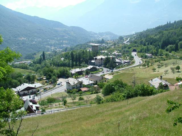
Bourg-Saint-Pierre
Hiking in Bourg-Saint-Pierre
Bourg-Saint-Pierre is a picturesque village located in the Swiss Alps, nestled in the Valais Canton. It serves as a fantastic base for hiking enthusiasts due to its stunning landscapes and diverse trails. Here are some highlights about hiking in the area:...
- Страна:

- Почтовый код: 1946
- Телефонный код: 027
- Код автомобильного номера: VS
- Координаты: 45° 57' 0" N, 7° 12' 0" E
- GPS треки (wikiloc): [Ссылка]
- Высота над уровнем моря: 1623 м m
- Площадь: 90.2 кв.км
- Население: 181