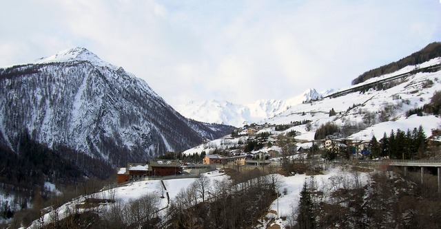
Bourg-Saint-Pierre (Bourg-Saint-Pierre)

 Hiking in Bourg-Saint-Pierre
Bourg-Saint-Pierre is a picturesque village located in the Swiss Alps, nestled in the Valais Canton. It serves as a fantastic base for hiking enthusiasts due to its stunning landscapes and diverse trails. Here are some highlights about hiking in the area:
Trail Options:
-
Bourg-Saint-Pierre to Col du Grand Saint-Bernard: This trail offers breathtaking views of the surrounding mountains and valleys. It's a historic route that has been used for centuries, leading toward the famous Grand Saint-Bernard Pass.
-
Valley Trails: Explore the trails along the local valleys, which provide gentler hikes with beautiful scenery and opportunities to observe local flora and fauna.
-
Montée de la Combe d’Aroul: A more challenging ascent that rewards hikers with panoramic views at the summit. This trail is ideal for those looking for a workout in addition to stunning scenery.
-
Nature Walks: For those who prefer a more leisurely pace, there are several nature walks that allow for a deeper appreciation of the local environment, with plenty of opportunities for photography.
Access and Facilities:
- Public Transport: Bourg-Saint-Pierre is accessible by train and bus, making it easy to get to various trailheads. Check the latest schedules for connections.
- Hiking Maps: Local visitor centers and online resources offer detailed maps and trail information. Make sure to pick one up before heading out.
- Guided Tours: For beginners or those unfamiliar with the area, consider joining a guided hike to enhance your experience and ensure safety.
Best Time to Hike:
- Summer (June to September): The best time for hiking, with trails cleared of snow and temperatures moderate.
- Autumn (October): Fall colors can make for stunning views, though early snowfalls may begin to close higher altitude trails.
Safety Tips:
- Weather Awareness: Always check the weather forecast before your hike, as conditions can change rapidly in the mountains.
- Gear Up: Wear sturdy hiking boots and bring layers, including a rain jacket, as temperatures can vary.
- Stay Hydrated and Nourished: Carry enough water and snacks, especially for longer hikes.
Hiking around Bourg-Saint-Pierre provides an opportunity to experience the natural beauty and tranquility of the Swiss Alps. Whether you are a seasoned hiker or a beginner, there are trails suited for all skill levels. Enjoy your adventure!
- Страна:

- Почтовый код: 1946
- Телефонный код: 027
- Код автомобильного номера: VS
- Координаты: 45° 57' 0" N, 7° 12' 0" E


- GPS треки (wikiloc): [Ссылка]
- Высота над уровнем моря: 1623 м m
- Площадь: 90.2 кв.км
- Население: 181
- Википедия английская: wiki(en)
- Википедия национальная: wiki(de)
- Хранилище Wikidata: Wikidata: Q70157
- Катеория в википедии: [Ссылка]
- код Freebase: [/m/0h10wh]
- код GeoNames: Альт: [2661428]
- код VIAF: Альт: [158595722]
- ID отношения в OpenStreetMap: [1685281]
- код GND: Альт: [4574942-5]
- код LCNAF: Альт: [no99038951]
- идентификатор HDS: [2676]
- EMLO location ID: [577df4f9-c308-4083-ad3f-bca7be61f4e6]
- код швейцарского муниципалитета: [6032]
- код Цифрового атласа Римской империи: [7757]
- код Pleiades: [167684]
Граничит с регионами:


Этрубль
- коммуна Италии
Hiking in Этрубль
Etroubles is a charming village located in the Aosta Valley region of Italy, known for its stunning alpine landscapes and rich cultural heritage. Hiking in and around Etroubles offers a fantastic experience for outdoor enthusiasts, with a variety of trails suitable for different skill levels....
- Страна:

- Почтовый код: 11014
- Телефонный код: 0165
- Код автомобильного номера: AO
- Координаты: 45° 49' 17" N, 7° 13' 49" E
- GPS треки (wikiloc): [Ссылка]
- Высота над уровнем моря: 1280 м m
- Площадь: 39.57 кв.км
- Население: 489
- Веб сайт: [Ссылка]


Оломон
- коммуна Италии
Hiking in Оломон
Ollomont is a charming municipality located in the Aosta Valley region of Italy, known for its stunning natural landscapes and outdoor recreational opportunities, including hiking. Here are some insights into hiking in Ollomont:...
- Страна:
- Почтовый код: 11010
- Телефонный код: 0165
- Код автомобильного номера: AO
- Координаты: 45° 51' 0" N, 7° 19' 0" E
- GPS треки (wikiloc): [Ссылка]
- Высота над уровнем моря: 1356 м m
- Площадь: 53.48 кв.км
- Население: 157
- Веб сайт: [Ссылка]


Сент-Уайен
- коммуна Италии
Hiking in Сент-Уайен
Saint-Oyen, located in the Aosta Valley of Italy, is a picturesque destination for hiking enthusiasts. Nestled at the foothills of the Alps, this area is characterized by its stunning natural scenery, rich biodiversity, and a range of hiking trails suitable for various skill levels. Here are some highlights and useful information about hiking in this region:...
- Страна:
- Почтовый код: 11014
- Телефонный код: 0165
- Код автомобильного номера: AO
- Координаты: 45° 49' 0" N, 7° 13' 0" E
- GPS треки (wikiloc): [Ссылка]
- Высота над уровнем моря: 1373 м m
- Площадь: 9.42 кв.км
- Население: 194
- Веб сайт: [Ссылка]
Сен-Реми-ан-Босс
- коммуна Италии
Hiking in Сен-Реми-ан-Босс
Saint-Rhémy-en-Bosses is a picturesque village located in the Aosta Valley region of Italy, nestled in the Italian Alps. The area is known for its stunning landscapes, charming architecture, and many outdoor activities, including hiking....
- Страна:
- Почтовый код: 11010
- Телефонный код: 0165
- Код автомобильного номера: AO
- Координаты: 45° 49' 19" N, 7° 10' 32" E
- GPS треки (wikiloc): [Ссылка]
- Высота над уровнем моря: 1519 м m
- Площадь: 64.88 кв.км
- Население: 335
- Веб сайт: [Ссылка]