Фюрстенштайн (Fürstenstein, Fürstenstein)

 Hiking in Фюрстенштайн
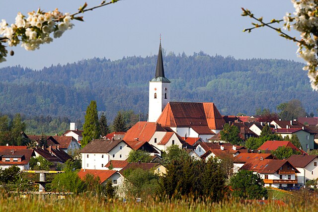
Fürstenstein, located in Bavaria, Germany, is an attractive destination for hiking enthusiasts. The region is known for its picturesque landscapes, beautiful forests, and rolling hills, making it an ideal spot for both casual walkers and seasoned hikers.
Hiking Trails
-
Well-Marked Trails: The hiking trails around Fürstenstein are generally well-marked, with signposts guiding hikers through various routes. Look for yellow and white trail markers, which indicate the paths.
-
Scenic Views: Many trails offer stunning views of the surrounding countryside, including hills and valleys, as well as glimpses of the nearby forests. Some paths may lead you to lookout points that provide panoramic views.
-
Themed Trails: You may also find thematic nature trails that focus on the local flora and fauna, making them a great choice for nature enthusiasts interested in photography or birdwatching.
Difficulty Levels
- Easy Trails: Perfect for families or those new to hiking; these trails generally have gentle inclines and well-maintained paths.
- Moderate Trails: Suitable for hikers with some experience; these may involve steeper sections and varied terrain.
- Challenging Trails: For seasoned hikers looking for a workout or adventure, more difficult routes can provide a reward with breathtaking views.
Preparation and Safety
- Proper Gear: Good hiking boots, weather-appropriate clothing, and enough food and water are essential. Depending on the season, consider bringing trekking poles for stability and extra traction.
- Weather: Always check the forecast before heading out, as conditions can change rapidly in hilly terrain.
- Companionship: It’s generally safer to hike with a friend or group rather than alone, especially on more challenging routes.
Attractions Nearby
- Fürstenstein Castle: While hiking, you might want to explore the local culture and history by visiting the nearby Fürstenstein Castle, which offers guided tours and historical insights.
- Local Wildlife: Keep an eye out for diverse wildlife; this area is home to various species, adding to the beauty of your hike.
Access
- Public Transport: The area is accessible by public transport, so check local schedules if you're not driving.
- Parking: If you are driving, there are usually parking areas available near the trailheads.
Hiking in Fürstenstein offers a blend of natural beauty, physical challenge, and cultural exploration, making it a great destination for anyone looking to enjoy the outdoors. Always remember to follow the Leave No Trace principles to preserve the natural beauty for others. Enjoy your hike!
- Страна:

- Почтовый код: 94538
- Телефонный код: 08504
- Код автомобильного номера: PA
- Координаты: 48° 43' 0" N, 13° 20' 0" E


- GPS треки (wikiloc): [Ссылка]
- Высота над уровнем моря: 577 м m
- Площадь: 19.3 кв.км
- Население: 3550
- Веб сайт: http://www.fuerstenstein.de
- Википедия русская: wiki(ru)
- Википедия английская: wiki(en)
- Википедия национальная: wiki(de)
- Хранилище Wikidata: Wikidata: Q509768
- Катеория в википедии: [Ссылка]
- код Freebase: [/m/02q6sjh]
- код GeoNames: Альт: [2923595]
- код VIAF: Альт: [150096532]
- ID отношения в OpenStreetMap: [958121]
- код GND: Альт: [4018820-6]
- идентификатор местоположения ArchINFORM: [13275]
- код LCNAF: Альт: [n80092106]
- Bavarikon ID: [ODB_A00001554]
- идентификатор муниципалитетов в Германии: 09275121
Граничит с регионами:


Айха-форм-Вальд
Hiking in Айха-форм-Вальд
Aicha vorm Wald is a beautiful village located in Bavaria, Germany, which offers several opportunities for hiking enthusiasts. The region is characterized by its picturesque landscapes, rolling hills, and lush forests, making it an ideal location for both casual walkers and seasoned hikers....
- Страна:
- Почтовый код: 94529
- Телефонный код: 08544
- Код автомобильного номера: PA
- Координаты: 48° 40' 25" N, 13° 17' 28" E
- GPS треки (wikiloc): [Ссылка]
- Высота над уровнем моря: 360 м m
- Площадь: 20.35 кв.км
- Население: 2026
- Веб сайт: [Ссылка]

Эгинг-ам-Зе
Hiking in Эгинг-ам-Зе
Eging am See, located in Bavaria, Germany, is a charming destination for outdoor enthusiasts, particularly those interested in hiking. The area is known for its scenic landscapes, including the beautiful Egginger See (Eging Lake), lush forests, and rolling hills. Here are some highlights and tips for hiking in Eging am See:...
- Страна:
- Почтовый код: 94535
- Телефонный код: 08544
- Код автомобильного номера: PA
- Координаты: 48° 43' 0" N, 13° 16' 0" E
- GPS треки (wikiloc): [Ссылка]
- Высота над уровнем моря: 399 м m
- Площадь: 23.66 кв.км
- Население: 3208
- Веб сайт: [Ссылка]


Нойкирхен-форм-Вальд
Hiking in Нойкирхен-форм-Вальд
Neukirchen vorm Wald, located in Bavaria, Germany, is a charming village that offers appealing hiking opportunities in a picturesque natural setting. The region is characterized by rolling hills, lush forests, and beautiful meadows, making it an ideal destination for hikers of all levels....
- Страна:
- Почтовый код: 94154
- Телефонный код: 08504
- Код автомобильного номера: PA
- Координаты: 48° 41' 0" N, 13° 23' 0" E
- GPS треки (wikiloc): [Ссылка]
- Высота над уровнем моря: 466 м m
- Площадь: 24.3 кв.км
- Население: 2071
- Веб сайт: [Ссылка]


Турмансбанг
Hiking in Турмансбанг
Thurmansbang is a picturesque village located in Bavaria, Germany, surrounded by the beautiful landscape of the Bavarian Forest. It's an excellent destination for hiking enthusiasts, offering a variety of trails that cater to different skill levels and preferences....
- Страна:
- Почтовый код: 94169
- Телефонный код: 08504
- Код автомобильного номера: FRG
- Координаты: 48° 46' 0" N, 13° 19' 0" E
- GPS треки (wikiloc): [Ссылка]
- Высота над уровнем моря: 494 м m
- Площадь: 32.93 кв.км
- Население: 2159
- Веб сайт: [Ссылка]


Титлинг
Hiking in Титлинг
Tittling is a small town located in Germany, specifically in the Bavarian region. It's nestled near the border with Austria and is surrounded by scenic nature, making it ideal for hiking enthusiasts. Here are a few highlights about hiking in and around Tittling:...
- Страна:
- Почтовый код: 94104
- Телефонный код: 08504
- Код автомобильного номера: PA
- Координаты: 48° 43' 33" N, 13° 22' 55" E
- GPS треки (wikiloc): [Ссылка]
- Высота над уровнем моря: 540 м m
- Площадь: 20.78 кв.км
- Население: 3860
- Веб сайт: [Ссылка]